339 Jefferson Faces Wrecking Ball

339 Jefferson Street. Fayette PVA

With spring comes the blossoming buds of the flowers, but it also seems to bring the wrecking ball. On March 4, 2016, a demolition permit was sought for 339 Jefferson Street.

The old house, according to records of the Fayette County PVA, was built around 1890* and is another example of Lexington’s disappearing vernacular architecture. The property owner as of January 1 was Dixon Enterprises, LLC, but the demolition permit reveals that LFUCG Code Enforcement is the applicant/owner. Dixon owns a significant amount of the center of the block.

339 Jefferson Street, then numbered 181 Jefferson, on the 1901 Sanborn Map. UK Libraries.

The house appeared on the 1901 Sanborn Map, but was then numbered 181 Jefferson Street. As noted above, the PVA records indicate that the house was built in 1890. The 1896 Sanborn map, however, does not indicate that any structures were yet constructed on that portion of the western side of Jefferson Street. As such, I believe that 339 Jefferson was built somewhere between 1897 and 1901 … ca. 1900 – 2016.

On August 27, 1910, the Lexington Leader reported that “the funeral services over the body of Mrs. Nannie L. Harvey of 339 Jefferson street, who died Friday afternoon will be held Sunday afternoon, the burial taking place in the Lexington Cemetery.” She was survived by her husband, the sole beneficiary under her will which was probated in November of 1910.

The Jefferson Street corridor is currently one of Lexington’s most active and exciting districts with new development and investment filling the area. Demolition of vernacular structures like these shotguns I highlighted last year is often a side effect of a historic area’s popularity. Other alternatives, like infill and redevelopment of blighted areas like what is going on in NoLi, exist.

It remains to be seen what will occur on this site. But until we know, RIP 339 Jefferson (ca. 1900-2016). After nearly six score together, we hardly knew thee.

The Lexington Country Club

Lexington Country Club in 2016. Author’s Collection.

The charter member list of the Lexington County Club reads as a “who’s who” of Lexington at the turn of the twentieth century. This first social club in Lexington was modeled after the clubs common and popular in larger cities in the eastern United States so that these leaders (men only) would have a place to relax. The Lexington Leader, then the local Republican newspaper, outlined the club’s purpose for prospective members and donors:

Think of having a charming place near town in easy driving distance, with an opportunity to enjoy country life in its most finished sense! Where men after business hours can go and take their families and guests for luncheon or dinner, outdoor and indoor games, where there are beautiful lawns and tennis and golf grounds and society in general go for dances and all sorts of diversions. In this way the most wholesome kind of social enjoyment can be developed and people have that for which they so often long and sign, a perfect resort for entertainment outside of their own homes. In nearly ever other city in America there is something on this order – a country club or a hunting club.

And so it was in 1901 that the Lexington Country Club organized with a site selected along Paris Pike. In 1907, the house that was utilized for the clubhouse was reinvented by the Columbus, Ohio architecture firm Richards, McCarty & Bulford whose work features prominently elsewhere in Lexington. The landscape architects of the Olmsted Brothers firm worked on improvements to the property. The facilities finally opened in October 1907 to a gala event.

Lexington Country Club prior to the 1925 fire. UK Libraries

Fire and Rebirth

Eighteen years later – on October 19, 1925 – the clubhouse caught fire. Schoolchildren from the Falconer school across the road helped to remove furnishings before the fire became too strong while firefighters from Lexington were dispatched. Despite the effort, the clubhouse was a total loss then measured at only $50,000. The decision was made to rebuild at once.

At the time of the fire, the club’s board was considering what to do with its facility and how it might grow its physical space. Had they deliberated for just a few years longer without the intervening fire, it is a worthy question to ask would the club have survived had the fire come just a few years later? The Great Depression arose following Black Friday four years and ten days following the fire that consumed LCC.

Instead, the fire occurred during the throes of the Roaring Twenties and its grand reopening was realized in June, 1926.  With its new facilities in place, the financial hardships brought on by the Depression and the Second World War were weathered by the club.

Marion Miley

None of these days, however, are the most remembered in club history. Instead, that honor is reserved for a more ghastly date: September 28, 1941.

In the early morning hours on that fall day, burglars broke into the Lexington Country Club hoping to retrieve money in the house which had been received during an event at the club earlier in the evening.

Miley arrived at the club as a resident on the club’s second floor when she was just 16: her father became the club’s golf pro and her mother managed the office. Though her father took a similar position in Cincinnati, both Marion Miley and her mother remained in Lexington. Miley’s golf game flourished winning many tournaments in the 1930s. By 1939, she was ranked #2 among amateur women golfers in the United States.

Marion Miley and Lexington Mayor Charles Thompson in 1935 on the steps of the old municipal building. UK Libraries.

But on that fateful evening it was found that Marion heard the noise downstairs when she went to the door of the second floor apartments she shared with her mother. At the door, she was met by her assailant and she was shot at close range.

Though the floor has since been replaced and the second floor remodeled, the spot where Marion Miley fell can be seen in the club’s ladies locker room. The legacy of Marion Miley, however, is best represented in a room that bears her name and contains mementos from her life. Additionally, an annual memorial tournament is held in the club in her honor.

The Club’s Ballroom in February 2016. Author’s Collection

A Post-War Evolution

Following the Second World War, the club evolved once again. Many members left to join the newly reorganized Idle Hour Country Club nearer to town on Richmond Road. Meanwhile, the Lexington Country Club took a more “family” approach with the addition of a swimming pool and other expansions. Today, its modern facilities enclosed within the heart of a space built in the 1920s create a welcoming environment for members and their guests.

On Wednesday, March 3, the Blue Grass Trust for Historic Preservation’s monthly deTours program will highlight the historic Lexington Country Club with a tour that is – as it is each month – free and open to the public. Additional details are available on Facebook.

Much of the information about the Lexington Country Club provided in this post was derived from the book, Lexington Country Club: A History of the First One Hundred years 1901-2001 by Rick Smoot (2004).

5 in ’15: The Best of the Kaintuckeean in 2015

The majority of posts on this site focus on Lexington, Kentucky history and historic preservation. But looking back at 2015’s most popular posts on the Kaintuckeean revealed a couple of fascinating details. One big overservation was that 4 of the 5 most popular posts were about subjects outside of Fayette County. That’s because, well, “Kentucky Kicks Ass.”

And 2 were from Nicholasville! So read on and discover the posts. Last year, I included the page of my book, Lost Lexington, in the rankings. Though it would have been #3 this year, I opted to include only posts. But thanks for continuing to love the book!

#1: Graded School Ruins Along the Dawkins Trail

The Ivyton School in Magoffin County can be spotted from the junction of the Dawkins Trail and the Mountain Parkway.

Read More: Graded School Ruins Along the Dawkins Trail

#2: No Destination: Griffith Woods

Griffith Woods, in Harrison County, once had a tavern that was relocated to Clark County in recent years.

Read More: No Destination: Griffith Woods

#3: Lexington’s Newest Disappearing Neighborhood

The 1920s houses in this area were demolished in 2015 to make way for the new Shriner’s Hospital

Read More: Lexington’s Newest Disappearing Neighborhood

#4: Another Nicholasville House is Gone

Another house from the 1920s is lost to demolition. This one is in Nicholasville. 

Read More: Another Nicholasville House is Gone

#5: A Snow Covered Nicholasville

A foot of snow on the ground in Nicholasville resulted in some beautiful pictures. Hoping we don’t repeat this in 2016!

Read More: A Snow Covered Nicholasville

Yes, there were a lot of great posts in 2015 and I hope to share some more of Kentucky’s awesome and rich history, people, and places in 2016!

One final statistic, the three busiest days on the Kaintuckeean were Feb. 23 (A Snow Covered Nicholasville), March 11 (Lexington’s Newest Disappearing Neighborhood), and November 30 (Graded School Ruins Along the Dawkins Trail). Those dates brought in a lot of traffic with some popular posts!

Thanks for a great 2015 and I wish you and yours a happy and prosperous New Years! 

Demolishing Little Addie Street

440 Addie Street, Lexington, Kentucky. Fayette PVA

The African-American enclave within Lexington known as Smithtown today has a recognizable name thanks to the brown ale from West Sixth Brewing Company that bears its name (it’s a tasty brew at 4.5%).

But the name Smithtown references a historically African-American neighborhood roughly bounded by Broadway, Jefferson, Fourth and Sixth streets. One of the streets within those bounds is Smith Street which runs between Fourth and Fifth streets.

Another short alley (Addie Street) only runs half that distance and is located to the east of Smith Street but to the west of Bourbon Street. I previously raised concerns about the demolition of vernacular architecture, like shotguns, in this immediate vicinity. In that post, I connected an affiliate of Transylvania University to the demolitions occurring as the school tries to increase its geographic footprint on Lexington’s northside.

452 Addie Street, Lexington, Kentucky. Fayette PVA.

Now, two new demolition permits have recently emerged on Addie Street. Both of these permits were sought by the new owner of the properties: Transylvania University.

Transylvania University’s demolition permits are for the addresses of 440 Addie Street and 452 Addie Street.

As noted above, this little alley is situated in the heart of the historically African-American Smithtown neighborhood. In 1995, the Herald-Leader wrote that Smithtown was “a historically black part of the Northside that is bordered roughly by North Broadway and West Fourth, Jefferson and West Sixth streets — has some crime, just like anywhere else. But it’s also filled with watchful residents who know who belongs in the neighborhood and who doesn’t.”

A search for “Addie Street” largely reveals the same pattern of crime referenced in the 1995 story, and the area has long had a rugged past. A search of historic newspapers indicates few references to this poor street and most relate to crime.

In 1940, Quincy Shelton was accused of at least two counts of vehicular manslaughter (a hit and run on Leestown Road which killed a 31 year old Woodford County farmer and a 24 year old painter from Lexington). Shelton actually resided at 452 Addie Street, one of the houses being demolished by Transylvania. Shelton was a school bus driver for the Fayette County.

1907 Sanborn Map which reflected the referenced properties, but not Addie Street itself. UK Libraries.

As for the shotguns themselves, the records of the Fayette PVA suggest construction in 1898 with square footages under 1,000 each. The 1907 Sanborn, the earliest to record the fire insurance of these parts of Lexington, reveals that 440 was likely 6 Addie Street. 452 Addie Street was previously numbered either 3 or 4. Addie Street itself, however, didn’t appear on the Sanborn map though it is clear that six shotguns were constructed by that point along the narrow path which would have later been made more accessible by a demolition at 516 West Fifth (see image above).

The Smithtown neighborhood grew following the Civil War; it was the home of many former slaves who now worked for a small wage, often for their former masters. Although once plentiful, the homes of these occupants are quickly disappearing.

For the most part, the loss of any one shotgun structure is not necessarily a loss of historical proportion (there are, of course, exceptions). Sometimes, they are just “old buildings.” But one must consider the sheer volume of shotguns that once existed in Lexington; they are becoming a dying breed. And their collective loss is of historic proportion.

The Starting 5: October’s MVPs

The starting five? I’m thinking about Ulis, Labissiere, Murray, Poythress and Briscoe. How about you?

And over here on the Kaintuckeean, October’s Starting 5 were the month’s MVPs (Most Valuable Posts).

So what were October’s most popular posts?

A Ghoulish Walking Tour

The most popular post in October helped to promote what turned out to be an awesome event. #BGTdeTours’ October edition including a historical & ghost walk of Lexington’s past led by Kevin Steele of Lexington Ghost Walk and Creepy Crawl.

Read more at: http://www.kaintuckeean.com/2015/10/a-ghoulish-walking-tour-in-lexington.html

Griffith Woods

Griffith Woods. Author’s collection.

The only repeat on the list (September’s #1) comes back as October’s #3. The 745 acres of Harrison County land provides the purest glimpse of what Europeans first saw when the entered the Bluegrass region. This is what the land looked like when the Native Americans lived here. Griffith Woods is a cooperative effort between the Nature Conservancy, the University of Kentucky and the Kentucky Nature Preserves Commission. Originally called Silver Lake Farm, the area features some venerable trees that are more than 300 years old.

Read more at http://www.kaintuckeean.com/2010/07/no-destination-griffith-woods.html

Metes & Bounds: Measuring Up Kentucky

A long-form post which included much of the history of how Kentucky was first part of Virginia and its separation from the mother-Commonwealth, along with the breakdown of Kentucky into its 120 counties. Oh, yes, and there’s a little bit about a place called Transylvania!

The post also got picked up by KyForward.

Read more at http://www.kaintuckeean.com/2015/10/metes-and-bounds-measuring-up-kentucky.html

The Story of the Willis Green House

Willis Green House. Blue Grass Trust

Danville’s Willis Green House was constructed around 1800 and has a grand history. It was in very poor shape and was auctioned off in 2013 to a consortium that sought its preservation. The consortium then sold the property to individuals who are restoring it. The photographs in this post, many provided by the Blue Grass Trust, are great examples of ‘ruin porn’ completed with a “door to hell.”

Read more: http://www.kaintuckeean.com/2013/09/a-house-with-story-to-tell-willis-green.html

Daniel Midkiff’s Ascension

What began as a short #DemolitionWatch post about a house being demolished on Walton Avenue turned into something larger. A western Kentucky typhoid fever outbreak led a widow and her children to Lexington and to the city’s Pythian Home. The family later rented the house (demolished in September 2015). One of the children was Daniel Midkiff who became a major player in the central Kentucky equine industry.

Read more: http://www.kaintuckeean.com/2015/10/daniel-midkiff-rose-from-inmate-to.html

If you like these posts, you can keep up with the latest from the Kaintuckeean (and some great posts from other blogs) by following the Kaintuckeean on Facebook!

The Lord Giveth and the Lord Taketh Away

St. Peter Claver Catholic Church is located at the northeast corner of Jefferson and Fourth streets in Lexington’s Northside neighborhood. On November 6, 2015, the demolition permit was issued for this holy place.

But we knew it was coming.

The demolition is part of Phase II of a rehabilitation of the campus for this parish which dates to the 1880s. According to an April 1907 edition of the Lexington Leader, a “Catholic Church for the Negroes in Lexington is now under organization [and] a chapel has been secured in the colored Catholic school on West Fourth street, near Jefferson, and it will be opened within a short time.” Previously, space was reserved “in the local Catholic Church for the colored people to worship.”

In Phase One, the ca. 1913 parish school was renovated earning high marks and awards from historic preservationists. Now, in Phase Two, the church builing (mid-20th century) is being demolished to make way for a larger sanctuary.

Although in 1995, the Diocese cut the number of priests at the three downtown parishes from 3 to 2, the St. Peter Claver Catholic Church has been bursting at the seams. The new facility will have seating for 450, up from about 250. It is a growing parish that is serving the needs of its community.

Saint Peter Claver was a Jesuit priest. A Spanish native who immigrated to present-day Columbia in 1610. Among other things, he is the patron saint of race relations and ministry to African-Americans. He was canonized in in 1888 by Pope Leo XIII.

The Old Protestant Infirmary Grew to Become Samaritan Hospital

333 East Short Street in Lexington, Kentucky was once home to Good Samaritan Hospital. Author’s collection.

The Women’s Guild of Christ Church Episcopal Church established in 1888 an infirmary for the care of Lexingtonians.It would be Lexington’s second hospital, St. Joseph having been established by Catholic Church in 1877.

The mission began in Farmer Dewees’ ca. 1814 White Cottage located on East Short Street which the Guild purchased for $5,000 from Bernard Fotch. The cottage had been home in the late 1830s to H.H. Gratz, the editor of the Kentucky Gazette; it was ultimately torn down  in 1940.

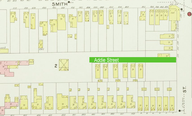
The 1890 Sanborn Map of Lexington shows the White Cottage and the adjacent Infirmary. UK Libraries. 

The Dewees House on East Short Street, ca. 1907. UK Libraries

Good Samaritan Hospital 

According to the Herald-Leader, which published a history of the medical facility on the occasion of its golden anniversary, the physical plant of the infirmary cost just under $40,000. Although no records exist from 1888, 1889 witnessed some 659 patients being treated here. The operating budget in that year for the infirmary was just over $11,000.

Also in January 1889, the Episcopal Women’s Guild transferred control of the infirmary to a consortium of Protestant churches of the Baptist, Christian, Episcopal, Methodist, and Presbyterian faiths. A decade later, in 1899, the Protestant Infirmary was also renamed as the Good Samaritan Hospital.

Realizing the need for nurses, a nursing school was established at the hospital and the first class of nurses graduated in 1893. In perhaps an unrelated note, an effort was made “to get [the] red light district moved away from neighborhood of Protestant Infirmary” according to the Morning Transcript in August 1894. (Belle Brezing’s infamous bordello was only a one-and-a-half blocks away at 59 Megowan which is now the corner of Wilson Street and Eastern Avenue).

Additions and annexes to the facility were constructed on multiple occasions, including those in 1895 and 1897. Below shows the Good Samaritan Hospital as it appears on the 1907 Sanborn map, including an operating room, laundry building, colored ward, and morgue.

1907 Sanborn map of Lexington depicting Good Samaritan Hospital. UK Libraries

To Be Vacated

At the bottom of the 1907 Sanborn is a notation that the buildings of Good Samaritan Hospital are “to be vacated in the near future.” Plans had developed in 1905 for a new and modern medical facility which purchased land at 310 South Limestone Street from W. H. McCorkle. The site had once been part of the James O. Harrison estate, with Mr. Harrison having passed away in his home on the site in 1888.

Mr. Harrison was a prominent citizen and early leader in Lexington’s local school system (for him, Harrison Elementary is named). His daughter, Mary Eliza, was a member of the Women’s Guild which helped establish the Protestant Infirmary in the first place.

In 1907, the Good Samaritan Hospital relocated to its new 130-bed hospital. In 1924, the Methodist Church took exclusive control of Good Samaritan. It would change hands several more times during the 20th century. In 2007, Samaritan Hospital filed for Chapter 11 bankruptcy relief and the University of Kentucky Healthcare system purchased the medical facility during the bankruptcy.

Coffee Times

But the structure on East Short Street remained standing. A public sale of the structure in 1920 brought it into the hands of W.T. Woolfolk whose Woolkfolk Coffee Company thereafter called it home. The coffee company had previously been located on Vine Street between Upper and Mill.

Nota Bene: Keep Peanuts Off the Floor Signage at 333 East Short. Author’s collection.

Remembrances of the coffee days can be found around the building with stampings of the Greenbag Coffee on the walls. Too, are advices to keep peanuts off the floor.

WWII Poster. Coffee Crossroads.

Of Mr. Woolfolk, this was written in the Lexington Leader preceding a 1905 election: “William T. Woolfolk, of the wholesale grocery firm of Martin & Woolfolk, corner of Mill and Market streets, is the Republican candidate for member of the Lower Board of the City Council in the First Ward. Mr. Woolfolk was born and reared in Garrard County, Ky., and came to Lexington about fifteen years ago, engaging in the retail grocery business at High and Broadway.”

Wool folk’s coffee and peanut operation ended near the start of World War II, according to news reports. This was no doubt due to the federal policy of coffee rationing which began in 1942.

A New Role

Since World War II, the old Protestant Infirmary has been the home of Hurst Office Supply. In 2014, the structure was acquired at public sale by Zeff Maloney through one of his businesses. Since, he has gone through a paintstaking process of bringing beauty back to this nineteenth century structure and adapting it for modern use.

Now the structure is rented to various commercial interests including a spa, insurance offices, and law offices. In the process of restoration, Maloney extracted some ten tons of plaster from the building which had covered the beautiful interior brick.

Interested in seeing this awesome place? Join the #BGTdeTours which is hosting a tour of 333 East Third Street on November 4, 2015 beginning at 5:30 p.m. Details about this event are available on Facebook. And if you can’t make it, come visit one of the businesses that now call the old Protestant Infirmary home.

Remaining plaster indicates the intensive process of removing it.
Author’s collection.

Gone but not forgotten, part deux: the George H. Bowman House

George H. Bowman House – Lexington, Kentucky. Author’s collection.

An earlier version of this post appeared on this site in 2013 in what was, in reality, an early version of #DemolitionWatch. Based on a zoning change request, this structure had a lot of charm and appeal. But now the demolition permit was sought last week (October 20, 2015) for the old house at 4145 Harrodsburg Road. The land, which backs up to the Palomar subdivision, will be absorbed into that residential area. 

In the spring of 2013, I spotted a sign in front of 4145 Harrodsburg Road indicating that a zoning request for the parcel would be from R-1D to R-1T. I rode onto the property, site of an abandoned home, to investigate further.

As it turns out, the residence was the George H. Bowman House, a ca. 1860 Greek Gothic Revival according to the Kentucky Historic Resources Survey conducted on the property in 1979.

Site Layout of Bowman House
Layout of Bowman House (Source: Resources Inventory)

Property owners, according to early county maps, identify the owner in 1891 as John McMeekin who was the son of Jeremiah McMeekin. The elder was a butcher who had purchased Helm Place in 1873.

The owner in 1871 was J. S. Burrier, originally of Jessamine County, who acquired the home and 165 acres that year. He was married to Alice Craig, daughter of Lewis and Martha (Bryant) Craig.

It is believed that George H. Bowman constructed this house ca. 1860, though he remained only a few years. After inheriting Helm Place from his father, pioneer Abraham Bowman, George H. was forced to sell much of his inheritance to satisfy a gambling debt.

A. J. Reed took advantage of the younger Bowman’s misfortune and acquired the Helm Place property in 1859. It is believed that our subject house was built for George’s occupancy after the liquidation of Helm Place. Within the decade, George H. Bowman had passed away and his children divided and sold their father’s property.

Back to the present. The zoning change mentioned permitted the demolition of the Bowman House and the erection of four townhouse units in its place. It is worth noting, however, that the data relied on in the Map Amendment Request (MAR) included inaccurate data from the Fayette County PVA office.

The existing house was build in 1940, according to PVA records. Unfortunately, since the grant of the previous zone change (and prior to the purchase by the applicant) the house has fallen into a state of disrepair. There are structural issues relating to the foundation. Also contents and mechanical systems of the house have been torn out by unknown persons. Exterior decay issues are present. For all these reasons, it is impossible to preserve the house. (MARV 2013-3 Amd.pdf)

I truly doubt that preservation was an impossibility. Impracticable, perhaps. But not impossible. Several additional references existed in the MAR to the “1940 house.”

I was glad to have snapped these pictures before the old Bowman House was demolished. (I’m assuming demolition has occurred – any updates to the project?)

George H. Bowman House – Lexington, Kentucky. Author’s collection.

Interior George H. Bowman House – Lexington, Kentucky. Author’s collection.

6 in September: The Most Popular Posts

Though there were only four new Kaintuckeean posts from September, there was a lot of strong traffic out of the archives. Below are the six most popular posts from September.

Griffith Woods

Griffith Woods. Author’s collection.

The 745 acres of Harrison County land provides the purest glimpse of what Europeans first saw when the entered the Bluegrass region. This is what the land looked like when the Native Americans lived here. Griffith Woods is a cooperative effort between the Nature Conservancy, the University of Kentucky and the Kentucky Nature Preserves Commission. Originally called Silver Lake Farm, the area features some venerable trees that are more than 300 years old.

Read more at http://www.kaintuckeean.com/2010/07/no-destination-griffith-woods.html

A #DemolitionWatch Update

Fritz Farm. Fayette County PVA

One post from September helped to catch readers up on the many demolitions that have occurred around Lexington over the past couple months. Significantly, the circa 1875 farmhouse at Fritz Farm near the corner of Nicholasville Road and Man-O-War was demolished to make way for the future mixed-use development known as The Summit at Fritz Farm.

Read more at http://www.kaintuckeean.com/2015/09/catching-up-on-lexingtons-recent.html

Lost Lexington at the University of Kentucky

This post was a promotional post for an event I had at UK’s Singletary Center to speak about my book, Lost Lexington. What made the event more special was that it was the inaugural event in the Hemenway Writing Center Speaker Series! It was a great event with a great group of attendees who asked some great questions!

Read more at http://www.kaintuckeean.com/2015/09/lost-lexington-coming-to-university-of.html

3,849 Images from Lexington’s Past

Cadets along Main Street. UK Libraries. 

UK Libraries unveiled a new collection which included some incredible photographs from Lexington’s past. The photos, digitally extracted from dry plate, silver nitrate glass negatives, date from ca. 1898-1918.

Read more at http://www.kaintuckeean.com/2015/07/6-images-from-lexingtons-past-and-3848.html

Riverside Historic District

Audubon Statue at the Point. Michael Monks

A guest post from the archives, written by Michael Monks of RCNKy.com, is about the Riverside Historic District in Covington. This treasure includes eight blocks along the Licking River beginning at the confluence with the Ohio River. Architecture of the “Greek Revival, Federal, Queen Anne, High Victorian, Gothic, Italianate, and French Second Empire styles” can be found here.

Read more at http://www.kaintuckeean.com/2012/07/RiversideHD.html

Silas Baptist Church

Like many churches in the region from both the Baptist and Disciples of Christ traditions, Silas Baptist draws from the heritage of the Traveling Church which was founded in Virginia in 1767.  This July 2010 offers image and text from the on-site historic marker with a little extra insight on this oldest continuously running church in Bourbon County.

Read more: http://www.kaintuckeean.com/2010/07/no-destination-silas-baptist-church.html

Discover more and follow the Kaintuckeean on Facebook!

A Ghoulish Walking Tour in Lexington

The BGT deTour this month is more than just a walking tour. It’s a ghoulish walking tour featuring the torrid tales of Lexington’s past. Plus, a lot of interesting history!

Local folklorist and ghost guide Kevin Steele will lead the tour that will begin at 5:30 p.m. on Wednesday, October 7 near the corner of West Second and Jefferson Streets.

Kevin Steele is a local ghost guide and folklorist. Kevin Steele

Each year, Kevin Steele leads the popular Lexington Ghost Walk and Creepy Crawl on Thursday, Friday and Saturday evenings in October. But Kevin (a regular deTourian) has agreed to share some his expertise with the #BGTdeTours crowd.

The tour will include the Vogt Reel House, Hampton Court, the Green Lantern and other destinations. The walk will conclude at Blue Stallion Brewing Company which is generously donating 10% of deTourian sales to the Blue Grass Trust.

If you are on Facebook, let your friends know you are going on this #BGTdeTours – click here!


IF YOU GO
October 7, 2015
Gather at 5:30 p.m.

Starts Near Second & Jefferson, Lexington

Free and open to the public. An AfterHour at Blue Stallion Brewing Company follows with a percentage of proceeds supporting the Blue Grass Trust.
#BGTdeTours