5 in ’15: The Best of the Kaintuckeean in 2015

The majority of posts on this site focus on Lexington, Kentucky history and historic preservation. But looking back at 2015’s most popular posts on the Kaintuckeean revealed a couple of fascinating details. One big overservation was that 4 of the 5 most popular posts were about subjects outside of Fayette County. That’s because, well, “Kentucky Kicks Ass.”

And 2 were from Nicholasville! So read on and discover the posts. Last year, I included the page of my book, Lost Lexington, in the rankings. Though it would have been #3 this year, I opted to include only posts. But thanks for continuing to love the book!

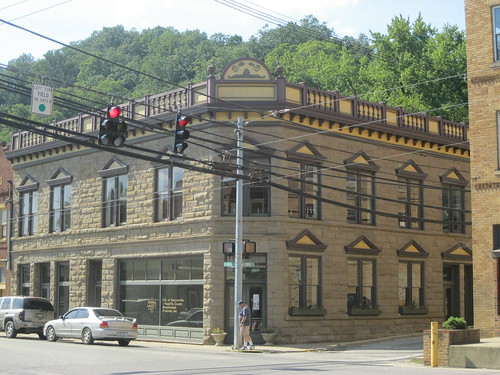
#1: Graded School Ruins Along the Dawkins Trail

The Ivyton School in Magoffin County can be spotted from the junction of the Dawkins Trail and the Mountain Parkway.

Read More: Graded School Ruins Along the Dawkins Trail

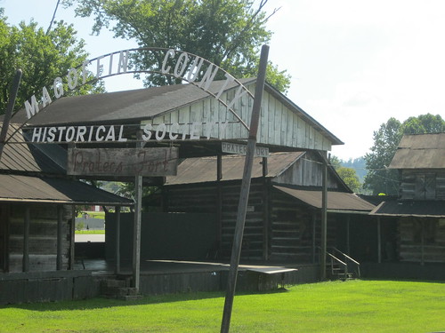
#2: No Destination: Griffith Woods

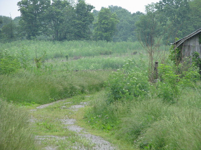
Griffith Woods, in Harrison County, once had a tavern that was relocated to Clark County in recent years.

Read More: No Destination: Griffith Woods

#3: Lexington’s Newest Disappearing Neighborhood

The 1920s houses in this area were demolished in 2015 to make way for the new Shriner’s Hospital

Read More: Lexington’s Newest Disappearing Neighborhood

#4: Another Nicholasville House is Gone

Another house from the 1920s is lost to demolition. This one is in Nicholasville. 

Read More: Another Nicholasville House is Gone

#5: A Snow Covered Nicholasville

A foot of snow on the ground in Nicholasville resulted in some beautiful pictures. Hoping we don’t repeat this in 2016!

Read More: A Snow Covered Nicholasville

Yes, there were a lot of great posts in 2015 and I hope to share some more of Kentucky’s awesome and rich history, people, and places in 2016!

One final statistic, the three busiest days on the Kaintuckeean were Feb. 23 (A Snow Covered Nicholasville), March 11 (Lexington’s Newest Disappearing Neighborhood), and November 30 (Graded School Ruins Along the Dawkins Trail). Those dates brought in a lot of traffic with some popular posts!

Thanks for a great 2015 and I wish you and yours a happy and prosperous New Years! 

Graded School Ruins Along the Dawkins Trail

Ivyton Graded School – Ivyton, Ky. Author’s collection.

Harold Ickes said that “the new rural schools, made possible by good roads, are quite as
modern as the best city schools. Where it was necessary to have eight one-room schools in the
past, there is now a single eight-room school.” Ickes would know: he served as President Franklin Roosevelt’s Interior Secretary and was responsible for implementing the New Deal. 


Although a number of New Deal programs were involved in building new schools, the Works Progress Administration was the most active. The WPA channeled “more than $162 million through
thousands of state projects and had as many as seventy-two thousand Kentuckians on the 
payroll in the September 1938 peak.”
(Blakey 1986, 59). 


One of those schools is the old Ivyton Graded School which is located just off the Mountain Parkway in Magoffin County. Perhaps you have noticed the ruins on the northern side of the roadway.

The Mountain Parkway (and Dawkins Trail) at Ivyton, Kentucky. Author’s collection.

The ruins first caught my eye when returning from a court hearing in Pikeville in 2013. It was a cold March and spring had not yet begun to bloom, leaving the ruins exposed. I was immediately drawn to the point that I reversed course so that I could explore. 


The Kentucky Heritage Council surveyed the site nine years earlier, in 2004, for its Inventory Survey, observing that

Ivyton School under construction. UK Libraries.

All that remains of the building is the exterior walls. The structure is constructed of  ashlar sandstone blocks laid in broken range work. The school was a one-story, three-bay (w/d/w), side-gabled structure. The centered, arched entry of the façade, constructed with quoins and a keystone, projected slightly from the wall place of the façade. A date stone directly above the entry states: “WPA 1938”. Stone quoins are found on each corner of the structure. None of the windows remain. Each of the window openings has a keystone. The southwest gable end of the structure has three large window openings, a window opening near the apex of the wall and a stone chimney. The school appears to have been constructed in a “T” shape, with a perpendicular gable-roof section projecting from the rear of the structure. 

Date stone at the old Ivyton Graded School – Ivyton, Ky. Author’s collection.

Above is a photograph, taken in 2013, of the date block directly above the entrance to the old graded school. 


I recently returned from another court appearance in Pikeville and made it a point to again visit the ruins. This time, I knew that the Dawkins Trail (Kentucky’s longest rail-trail) crossed the Mountain Parkway at Ivyton. So I explored further on foot. Within a short walk from what has become a de facto trailhead at Ivyton are two of the most unique locations along the 18-miles of open trail, including a 662-foot tunnel and the bridge trussle over the Mountain Parkway. 


So next time you are traveling the Mountain Parkway, be sure to see if you can spot the old Ivyton Graded School!

The afternoon sunlight hits the Ivyton School ruins in November 2015. Author’s collection


NoD: Salyersville Bank

Salyersville, Ky.
Salyersville Bank Building – Salyersville, Ky.

One building in downtown Salyersville stands out: the Salyersville Bank at the corner of Church (KY 7) and Maple (US 460). An impressive two-story limestone structure in the Beaux Arts style constructed by Italian craftsmen who arrived in eastern Kentucky during a coal boom in the early twentieth century. Built in 1912, the Salyersville Bank anchored Salyersville’s growth.

A short-lived oil boom beginning in 1918 marked the county’s oil fields as producing the third highest volume in the state by 1922. The bank was instrumental in securing the funds the enterprise required. A 1927 flood caused great damage to Salyersville’s commercial district, but the bank remained open and able to help local merchants get back on their feet.

When the Great Depression hit, the Salyersville Bank continued to operate in part to its sound financial practices. The dirt roads of downtown Salyersville were certainly affected by the Depression, but this institution helped to convert the town’s center in 1936 from wood to brick. Many of the yellow brick buildings on Church Street across from the courthouse bear the 1936 construction date.

The Salyersville National Bank, chartered in 1902, no longer operates out of this location, but the institution remains in business elsewhere in the county.  Although Salyersville and Magoffin County have fallen on hard times in the past few decades, the Salyersville Bank building remains as a testament to the community’s prosperity a century ago.

Source: Nat’l Register

NoD: Prater’s Fort, Pioneer Village and a History Remembered in Salyersville

Prater's Fort - Salyersville, Ky.
Prater’s Fort – Salyersville, Ky.

Despite being one of America’s poorest counties, Magoffin County has not forgotten her rich history. The county’s historical society is incredibly active from its location in the old Salyersville post office on Church Street.

Adjacent to the historical society’s offices is a recreated pioneer village with fifteen authentic log buildings that have been collected from around the county and rebuilt at the site. Inside the structures, period furniture, post office cages, and other historic memoriabilia tell the tale of Magoffin County’s settlers.

Salyersville, Ky.The name Prater’s Fort is an early name for a settlement on the upper part of the Licking River – a site where Salyersville would eventually be incorporated. Logically, Prater’s Fort was, well, a fort established by Archibald Prater (1755-1831). Prater said of the area that “he looked unto these hills and found his hopes and dreams.”

A nearby pyramidal memorial to the “Early Founders of Magoffin County” celebrates Prater, as well as William “Uncle Billie” Adams (1802-1881) and state legislator Samuel Salyer (1812-1890). Adams was the namesake of Adamsville (the town that would become Salyersville); it is said that “he dreamed of a town that would never die.” Salyer served in the state legislature and worked to have Magoffin County created; it is for him that Salyersville was named when the county was formed in 1860.

More photos from Salyersville can be seen on flickr.

Magoffin County Courthouse – Salyersville, Ky.

Magoffin County Courthouse – Salyersville, KY
Salyersville is an interesting place. It’s a nice little mountain town, but I was surprised to discover that this was the courthouse. It is apparently one of many courthouses to have been located on this site over the years. The second courthouse built here, which was apparently of Victorian style and was quite unique, burned down. This is either the third or the fourth courthouse, but it is dwarfed by the new judicial center in town. 
Like most of the area, Magoffin County is a coal county. Interestingly, most native Magoffin County folks can probably trace their ancestors back to South Carolina, as the area was first settled in 1794 by a small group of settlers from South Carolina that built a community around the Licking River around what is now Salyersville.