Then & Now: Impeachment in Kentucky

If you’ve followed local news in Kentucky the past few days, the word “impeachment” has come up more than once. It was front page news in Wednesday’s news. (August 31, 2016). That’s because of a news story out of Jessamine County. I’m not going to go into the issues on this site because there are plenty of news sites covering the story du jour. Let’s just say that Kentucky is living up to its hype as the place where “politics [are] the damnedest.”

Let’s instead look at the historical side of impeachment in Kentucky. In 1991, the Legislative Research Commission published an Informational Bulletin entitled Impeachment in Kentucky “designed to assist future legislatures in conducting impeachments, and to provide the public with a look into the process itself.”

Section 68 of Kentucky’s 1891 Constitution provides that the “Governor and all civil officers” are subject to impeachment. Throughout the history of the Commonwealth, however, there have been only four impeachments. These are there stories.

Thomas Jones, Surveyor of Bourbon County

In 1803, the surveyor of Bourbon County was impeached by the Kentucky House of Representatives. This incident was long lost to history until it was discovered in 1991 by then-professor John Rogers of the University of Kentucky College of Law who was acting as Special Advisor to the House Impeachment Committee in the Burnette case (described below). Professor Rogers is now Judge Rogers of the Sixth Circuit Court of Appeals.
In his capacity as surveyor, Jones helped to establish land boundaries for private citizens and government entities alike. He served an important role and his errors would result in litigation for decades. His charge of impeachment was “for overcharging the state for work done, for failure to perform his duties, and for surveying the wrong tracts of land.” 
After approved by the House, the articles of impeachment were transferred to the Senate for trial. During the trial, Jones resigned his position though the Senate proceeded with the charges and ordered him “perpetually excluded from office.” 
The case is particularly unique because it remains the only incident where a jury was empaneled to determine evidence for a legislature during a U.S. impeachment trial.

“Honest Dick” Tate, State Treasurer

“Honest Dick” Tate
An important lesson: if you are the treasurer of an organization, don’t take the money. “Honest Dick” apparently struggled with this lesson.
And although he had earned a reputation of honesty amongst his colleagues while serving in the general assembly. In 1867, he left the General Assembly to run for the office of State Treasurer.
In those days, there were no term limits for the position and “Honest Dick” “faithfully” served the Commonwealth as treasurer for over two decades.
That is, until he absconded most of the state’s treasury in March, 1888. He was impeached and tried in abstentia later that year being found guilty of four counts. 
Neither the funds nor Tate were ever seen again. When he abandoned both his post and his family, he did so aboard a train bound for Cincinnati. Later, his daughter received post cards from her father over the years with postmarks bearing the locales of San Francisco, Japan, Brazil, China, and British Columbia (Canada). It was reported that Tate died in China in 1890. 

Judge J.E. Williams – McCreary County

All in 1916: the citizens of McCreary County charged that their local judge executive “had committed numerous acts of misfeasance and malfeasance as county judge.” The House voted to impeach, 48 to 45. In trial before the Senate, however, Judge Williams was acquitted. 
Conviction requires a vote of two-thirds of the Assembly and apparently the evidence was not sufficient. The Informational Bulletin speaks to why such a high burden exists: “[impeachment] is a several of the inherent power of the people in a democratic society to choose those who govern.” It’s worth noting that 19 states also afford the people in a democratic society to recall their elected officials and that Kentucky is not among that body of states.

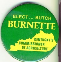
Ward “Butch” Burnette – Commissioner of Agriculture

In 1991, state Agriculture Commissioner Butch Burnette was convicted in Franklin Circuit Court of theft by deception.

According to his obituary in 2000, Burnette “served 49 days of a one-year sentence for a 1990 theft conviction for payment to a secretary before she actually began working. He was fined $1,500 in that case and $5,000 for an unrelated theft conviction involving charter flights taken at state expense after Mr. Burnette was elected in 1987 but before he took office in January 1988.”

The House adopted a single article of impeachment citing the conviction for a “theft of funds belonging to the Commonwealth.” Hours before the Senate commenced its trial, the Agriculture Commissioner resigned and the proceedings were terminated.

Will there ever be a fifth impeachment proceeding in Kentucky? Perhaps. But the stories of the first four are a fascinating part of the Commonwealth’s history.

The Starting 5: October’s MVPs

The starting five? I’m thinking about Ulis, Labissiere, Murray, Poythress and Briscoe. How about you?

And over here on the Kaintuckeean, October’s Starting 5 were the month’s MVPs (Most Valuable Posts).

So what were October’s most popular posts?

A Ghoulish Walking Tour

The most popular post in October helped to promote what turned out to be an awesome event. #BGTdeTours’ October edition including a historical & ghost walk of Lexington’s past led by Kevin Steele of Lexington Ghost Walk and Creepy Crawl.

Read more at: http://www.kaintuckeean.com/2015/10/a-ghoulish-walking-tour-in-lexington.html

Griffith Woods

Griffith Woods. Author’s collection.

The only repeat on the list (September’s #1) comes back as October’s #3. The 745 acres of Harrison County land provides the purest glimpse of what Europeans first saw when the entered the Bluegrass region. This is what the land looked like when the Native Americans lived here. Griffith Woods is a cooperative effort between the Nature Conservancy, the University of Kentucky and the Kentucky Nature Preserves Commission. Originally called Silver Lake Farm, the area features some venerable trees that are more than 300 years old.

Read more at http://www.kaintuckeean.com/2010/07/no-destination-griffith-woods.html

Metes & Bounds: Measuring Up Kentucky

A long-form post which included much of the history of how Kentucky was first part of Virginia and its separation from the mother-Commonwealth, along with the breakdown of Kentucky into its 120 counties. Oh, yes, and there’s a little bit about a place called Transylvania!

The post also got picked up by KyForward.

Read more at http://www.kaintuckeean.com/2015/10/metes-and-bounds-measuring-up-kentucky.html

The Story of the Willis Green House

Willis Green House. Blue Grass Trust

Danville’s Willis Green House was constructed around 1800 and has a grand history. It was in very poor shape and was auctioned off in 2013 to a consortium that sought its preservation. The consortium then sold the property to individuals who are restoring it. The photographs in this post, many provided by the Blue Grass Trust, are great examples of ‘ruin porn’ completed with a “door to hell.”

Read more: http://www.kaintuckeean.com/2013/09/a-house-with-story-to-tell-willis-green.html

Daniel Midkiff’s Ascension

What began as a short #DemolitionWatch post about a house being demolished on Walton Avenue turned into something larger. A western Kentucky typhoid fever outbreak led a widow and her children to Lexington and to the city’s Pythian Home. The family later rented the house (demolished in September 2015). One of the children was Daniel Midkiff who became a major player in the central Kentucky equine industry.

Read more: http://www.kaintuckeean.com/2015/10/daniel-midkiff-rose-from-inmate-to.html

If you like these posts, you can keep up with the latest from the Kaintuckeean (and some great posts from other blogs) by following the Kaintuckeean on Facebook!

Metes and bounds: Measuring up Kentucky

Used for centuries in England, the system of describing land by its metes and bounds is a common way of describing an area of land. Surveyors and other professionals utilize the system to specifically identify parcels of land though errors by the early surveyors creating much trouble in the early days.

Even with today’s surveys being done largely with technological advantage, it is possible for a call to be reversed and the wrong parcel be conveyed or mortgaged. The system of measured, however, is best understood by looking at the historic nature of how Kentucky itself came into being.

The Virginia Charters

In preparing for a presentation on the history of Lexington, I reviewed an online timeline of Fayette County. I’ve referenced this timeline before. It is a useful resource, but I questioned its first referenced fact when it suggested that the first Virginia charter (1606) included the territory that would become Kentucky.

Southern States of America, 1909. Available here.

Letting curiosity get the best of me, a quick Internet search offered a map of King James’ grants to the Plymouth and London Companies in 1606. As I suspected, they didn’t include the lands that would become Kentucky. A website called Virginia Places explained that the London Company “shall have all the landes, soile, groundes, havens, ports, rivers, mines, mineralls, woods, marishes, waters, fishinges, commodities and hereditaments whatsoever, from the firste seate of theire plantacion and habitacion by the space of fiftie like Englishe miles.

Additionally, the First Charter offered a company 100 miles inland from its first settlement. But 100 miles won’t reach Kentucky.

In 1609, the Second Charter extended rights of the Virginia Company to all lands within 200 miles to the north nad south of the James River. It also gave to the Virginia Company what was then unknown to be such a massive offering:

we do also of our special Grace… give, grant and confirm, unto the said Treasurer and Company, and their Successors… all those Lands, Countries, and Territories, situate, lying, and being in that Part of America, called Virginia, from the Point of Land,from the pointe of lande called Cape or Pointe Comfort all alonge the seacoste to the northward two hundred miles and from the said pointe of Cape Comfort all alonge the sea coast to the southward twoe hundred miles; and all that space and circuit of lande lieinge from the sea coaste of the precinct aforesaid upp unto the lande, throughoute, from sea to sea, west and northwest; and also all the island beinge within one hundred miles alonge the coaste of bothe seas of the precincte aforesaid. (emphasis added)

From sea to sea, eh? In these pre-Lewis & Clark days, there was still little concept of just how wide the continent truly is. The boundaries of Virginia evolved over the next century-plus before settling on the more familiar lines when, in 1784, Virginia ceded claims to northwestern lands to the U.S. government. At this point in history, Virginia consisted of the modern states/commonwealths of Kentucky, Virginia, and West Virginia.

Virginia: Breaking Up is Hard to Do
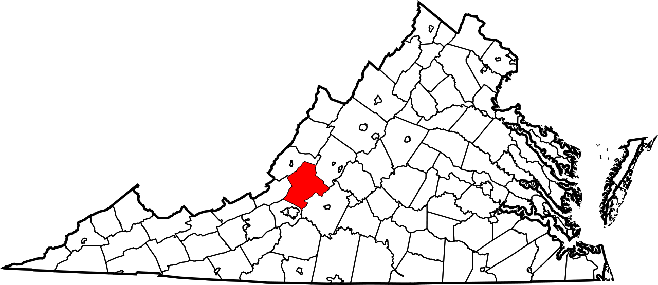
The remaining Botetourt County, Virginia. Public domain.

Kentucky arose from a still-extant Virginia county: Botetourt County which has been massively carved up over the centuries. Botetourt County was created in 1770, but the area that would become Kentucky was extracted in 1772 to become a portion of Fincastle County.

Fincastle County, which existed only through the conclusion of 1776, was carved up into three counties: Washington County (now exclusively part of Virginia), Montgomery County (which included parts of present-day Virginia and West Virginia), and Kentucky County.

Dr. Thomas Clark wrote, quoting Thomas Jefferson, that “obtaining justice should be made safe and easy as possible to all citizens.” It could be said that one reason for our declaration of independence from King George III was to achieve that dream of safe and easy justice. Of course, nothing about achieving justice has come with safety or with ease. Despite the challenges, shedding the chains of tyranny has become an American battle cry. This question framed the debate at our nation’s founding. And it framed the debate for Kentucky’s ultimate statehood.

Secretary of State.

Kentucky County survived only until 1780 when it was replaced by Jefferson, Fayette, and Lincoln counties. There was, at the time, a separate land claim for part of this area: Transylvania.

Transylvania Rises and Falls

Richard Henderson, a North Carolinian, led the Louisa Company (rechartered as the Transylvania Company) to secure the Treaty of Sycamore Shoals in a land purchase from the Cherokees. The treaty was signed on March 17, 1775, and could have given rise to the State of Transylvania, but these claims were disputed. Much of the land lied in the portion of Fincastle County that would become Kentucky County.

In 1778, Virginia invalidated all title to land arising through the Transylania Company. North Carolina followed suit in 1783. In the interim, the national government sought to clarify the boundaries in the territory northwest of the Ohio River.

To these ends, Virginia gave up its land claims in this area on January 2, 1781, but it also required Congress to take several actions including the affirmation of Virginia’s boundaries and the claims of her citizens within that area. Further, Virginia required that all other claims arising from arrangements not ratified by Virginia (read: the Transylvania Company) would be rejected.

In the end, the State of Transylvania would not rise with its validity being rejected by Virginia, the United States, and even North Carolina.

1792 and beyond

On June 1, 1792, Kentucky was admitted to the Union with the permission of the Commonwealth of Virginia. At the time, there were eight counties. Today, there are 120 counties.

The division of Kentucky’s territory into counties has not been without controversy either. Just as the separation of America from England and Kentucky from Virginia were precipitated by the need for local governance, so too was the case with the creation of many of Kentucky’s counties.

In 1798, the residents of Marble Creek labored “under great inconveniences from their detached situation from their present seat of justice.” They sought the creation of a new county. From their efforts spawned by a dispute with the leadership in Fayette County, these Jessamine Countians carved a territory Fayette.

And beginning around 1900, the people of western Carter County around Olive Hill did not appreciate the 30 or 40 mile journey to the county seat of Grayson. Olive Hill was becoming populous given the fire brick industry developing in that portion of the county. And political disputes also suggested a division. On February 9, 1904, the governor signed into law the formation of Beckham County out of portions of Carter, Elliott and Lewis counties with Olive Hill being designated as the new county seat.

Beckham County needed revenues and issued tax bills to her citizens. Mr. Zimmerman, once a resident of Carter County, challenged his $75 bill. Carter County, defending her tax base, joined with Mr. Zimmerman to challenge the constitutionality of Beckham County which was soon out of existence.

Though the name wouldn’t be known for a significant portion of the epoch, Kentucky’s geopolitical and cartographic history spans more than four centuries. Today, the boundaries are governed by Chapter 1 of the Kentucky Revised Statutes – statutes which reference U.S. Supreme Court decisions decided as late as the 1980s. And within these boundaries, Kentucky has been divided into public and private lands.

Surveyors and others have called the points which would make these divisions. Since 1983, the state legislature has authorized the use of GPS coordinates in addition to the metes and bound system which has added accuracy to the whole system.

Yes, the “sun shines bright on my old Kentucky home” as measured from the “stone at the seven pines” and beyond.

6 in September: The Most Popular Posts

Though there were only four new Kaintuckeean posts from September, there was a lot of strong traffic out of the archives. Below are the six most popular posts from September.

Griffith Woods

Griffith Woods. Author’s collection.

The 745 acres of Harrison County land provides the purest glimpse of what Europeans first saw when the entered the Bluegrass region. This is what the land looked like when the Native Americans lived here. Griffith Woods is a cooperative effort between the Nature Conservancy, the University of Kentucky and the Kentucky Nature Preserves Commission. Originally called Silver Lake Farm, the area features some venerable trees that are more than 300 years old.

Read more at http://www.kaintuckeean.com/2010/07/no-destination-griffith-woods.html

A #DemolitionWatch Update

Fritz Farm. Fayette County PVA

One post from September helped to catch readers up on the many demolitions that have occurred around Lexington over the past couple months. Significantly, the circa 1875 farmhouse at Fritz Farm near the corner of Nicholasville Road and Man-O-War was demolished to make way for the future mixed-use development known as The Summit at Fritz Farm.

Read more at http://www.kaintuckeean.com/2015/09/catching-up-on-lexingtons-recent.html

Lost Lexington at the University of Kentucky

This post was a promotional post for an event I had at UK’s Singletary Center to speak about my book, Lost Lexington. What made the event more special was that it was the inaugural event in the Hemenway Writing Center Speaker Series! It was a great event with a great group of attendees who asked some great questions!

Read more at http://www.kaintuckeean.com/2015/09/lost-lexington-coming-to-university-of.html

3,849 Images from Lexington’s Past

Cadets along Main Street. UK Libraries. 

UK Libraries unveiled a new collection which included some incredible photographs from Lexington’s past. The photos, digitally extracted from dry plate, silver nitrate glass negatives, date from ca. 1898-1918.

Read more at http://www.kaintuckeean.com/2015/07/6-images-from-lexingtons-past-and-3848.html

Riverside Historic District

Audubon Statue at the Point. Michael Monks

A guest post from the archives, written by Michael Monks of RCNKy.com, is about the Riverside Historic District in Covington. This treasure includes eight blocks along the Licking River beginning at the confluence with the Ohio River. Architecture of the “Greek Revival, Federal, Queen Anne, High Victorian, Gothic, Italianate, and French Second Empire styles” can be found here.

Read more at http://www.kaintuckeean.com/2012/07/RiversideHD.html

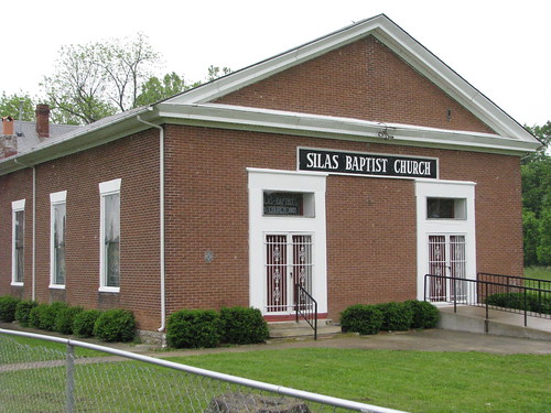
Silas Baptist Church

Like many churches in the region from both the Baptist and Disciples of Christ traditions, Silas Baptist draws from the heritage of the Traveling Church which was founded in Virginia in 1767.  This July 2010 offers image and text from the on-site historic marker with a little extra insight on this oldest continuously running church in Bourbon County.

Read more: http://www.kaintuckeean.com/2010/07/no-destination-silas-baptist-church.html

Discover more and follow the Kaintuckeean on Facebook!