Depending on the region of Kentucky in which you leave, the concept of a flood differs entirely. To the western Kentuckian accustomed to acres upon acres of flat cropland near the Ohio River, rising waters inundate the soil. And while damaging, there is little surprising when rainfall and upstream gauges indicate what is to come. At the opposite end of the spectrum are the hollow valleys in eastern Kentucky where a flash flood can wash out all a family knows in a matter of second. There is no warning. Central Kentucky lies somewhere in between. Regardless of how the floodwaters impact you or your region, when the waters rise they can cause tremendous damage. To livelihoods, to buildings, to towns, and to the land itself.
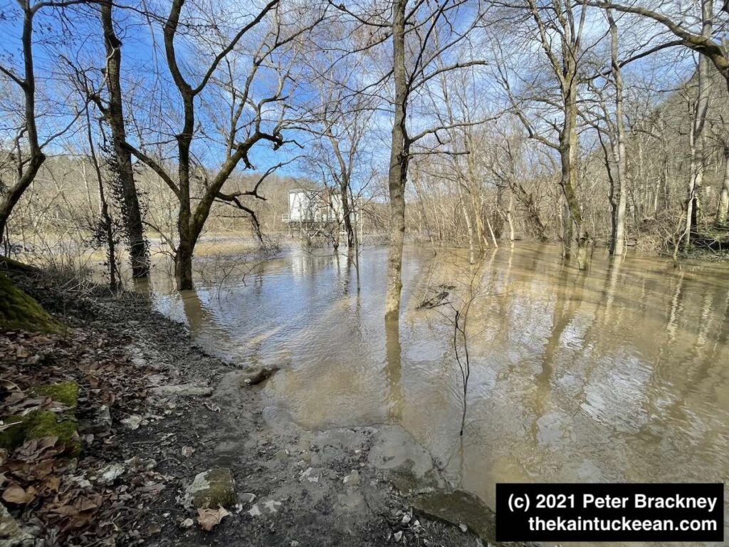
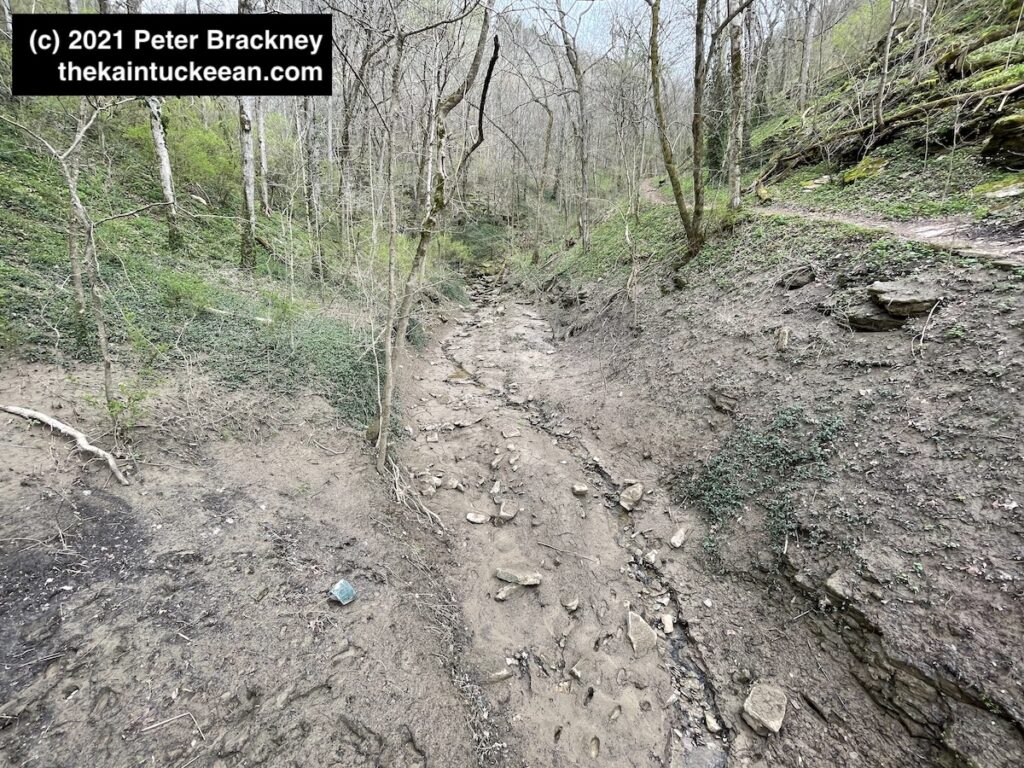
I have hiked Asbury Trails a few times so far in 2021. There was torrential rain on February 28, 2021, which led to significant flooding along the Kentucky River. I mean, significant. In the fall of 2020, the kids and I tossed rocks into the river from a rocky beach at the base of the Wilmore water intake. It’s been awhile since I’ve seen much of that little beach.
The water intake pumps were constructed in 1973 by Asbury University (nee College) before being transferred to Wilmore in 1977. In the picture below, you can see the intake pump near the center of the photograph. If you are familiar with these trails, you might notice immediately that the walking bridge is not in this focus as it is entirely submerged. Yeah.
Waterlogged Asbury Trails on March 5, 2021. Author’s collection.
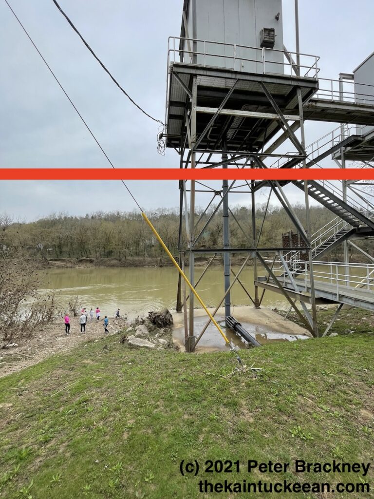
For a closer look at the water intake – and for comparison for how things should look, I offer the following photograph from March 27, 2021:
Wilmore Water Intake at the Kentucky River, March 27, 2021. Author’s collection.
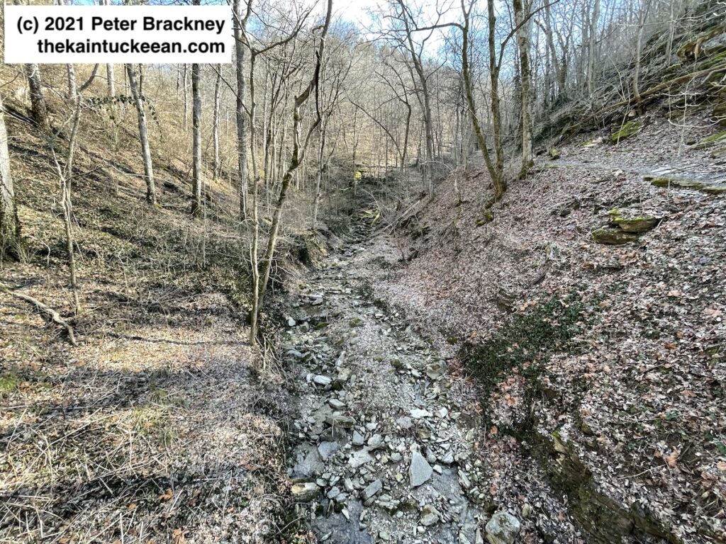
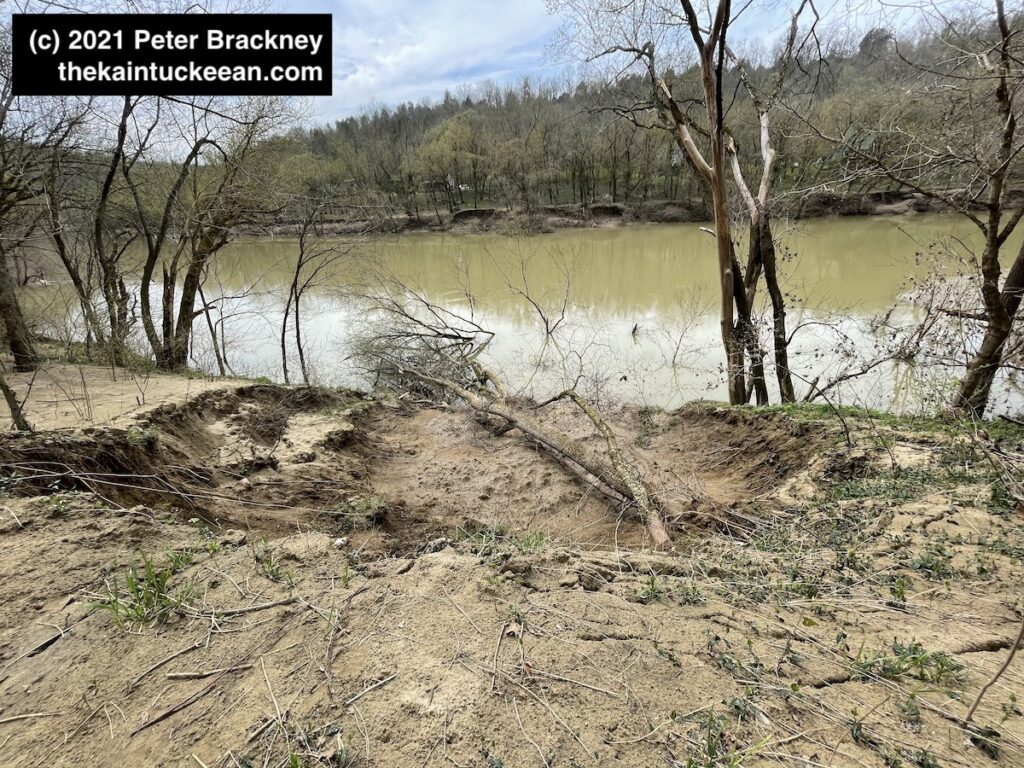
The red line indicates the high water mark that I personally observed earlier in March. From a different before-after perspective, the photograph immediately below is from early February 2021. The rock and leaf covered creekbed runs through the center of Asbury Trails. The second photograph shows the destruction caused from the late February rains. Remember that in both pictures, I am standing on a bridge that was completely submerged during the days of the rising waters.
Pre-flood from the Asbury Trails bridge, 5 February 2021. Author’s collection. Post-flood, from the Asbury Trails bridge, 27 March 2021. Author’s collection.
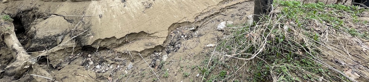
You can also see a new rut being created as the land evolves and the fresh rainwaters of March 2021 find their way to the Kentucky River. One final photograph of the land’s evolution is below showing the soil erosion adjacent to the trail as it runs alongside the river toward the spring, cave, and waterfall. Across the river, additional erosion was also visible.
Erosion visible on 27 March 2021 along the Kentucky River following late February/early March floods. Author’s collection.
I found myself discovering the western Kentucky of Paducah a couple years back in what was my first (and only thus far) trip to the Purchase. As you travel westward in Kentucky from the Bluegrass toward the Purchase, you realize the vastness of Kentucky (though, as a state we are only 37th in terms of square miles, and thus not particularly vast). Though it takes little time to traverse Kentucky from its southern border with Tennessee to either Illinois, Indiana, or even Ohio, the trek from “Pikeville to Paducah” is a easily a six-plus-hour drive.
Looking west on Broadway Street in downtown Paducah, Kentucky. Author’s collection.
But Kentucky’s vastness is not just in that east-west distance, but in the variety of terrain experienced across the landscape. Louisville is often carved out as not being particularly Kentucky-like, but the hills of eastern Kentucky couldn’t be more different than the open flatness of the Purchase. Here, the region is defined by water with the convergence of the Tennessee River into the the Ohio River, which in turn flows into the mighty Mississippi. These waters have huge impacts on commerce, culture, and the land itself.
Here in Paducah one encounters, I claim, an agreeable blend of Western kindliness, and Northern enterprises, superimposed upon a Southern background. Here, I claim, more chickens are fried more hot biscuits are eaten, more corn pone is consumed, and more genuine hospitality is offered than in any town of like size in the commonwealth.
Author, journalist, and native of Paducah Irvin S. Cobb
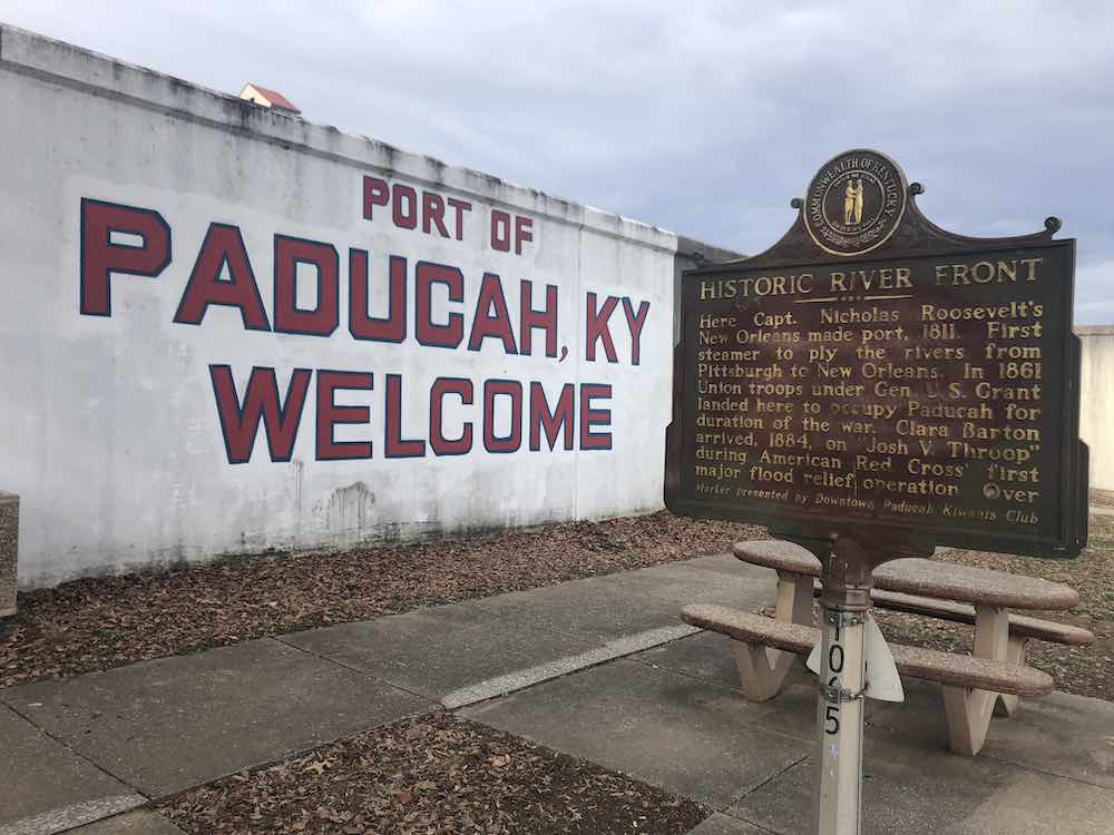
Historic Marker on the Paducah Riverfront, Paducah, Kentucky. Author’s collection.
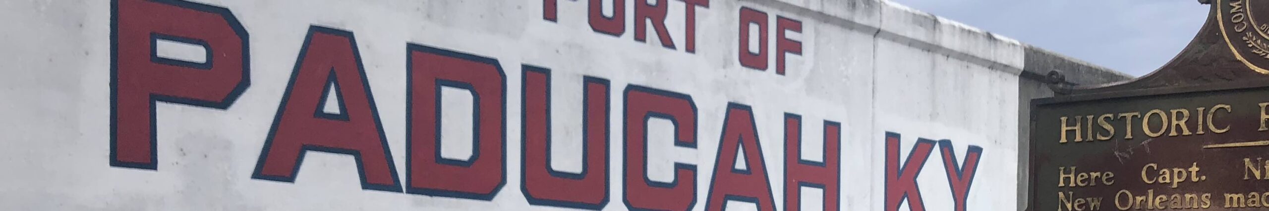
Port Paducah
The city of Paducah itself is separated entirely from the Ohio River by a series of flood walls. Without, the city would be vulnerable to constant flooding. The flood prone city experienced natural disaster with regularity, but none like the Great Flood of 1937. This natural disaster began with eighteen inches of rain which put the river more than 10 feet above flood stage. The river stayed above flood stage for nearly two weeks, the earthen works having been a total failure. Following this flood, Congress called upon the Army Corps of Engineers to build the existing flood wall system.
An earlier flood in the 1884 brought the founder of the American Red Cross, Clara Barton, to Paducah where the organization (founded in 1881) conducted its first flood relief operation. The organization assisted the nearly 30,000 refugees from the 1937 flood as well.
A historic marker on the outside of the flood wall highlights three historic events which occurred at Port Paducah:
Gen. George Rogers Clark visited this spot, 1778
Gen. Ulysses S. Grant landed here Sept. 6, 1861 to occupy Paducah for Federal Union.
Capt. Jack B. Sleeth laid first successful submarine cable, 1847. It reached from Campbell St. to Illinois shore.
A City and its Hall
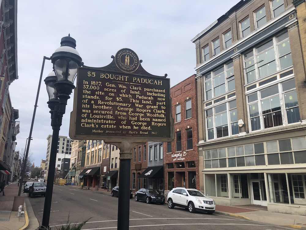
The land on which the city of Paducah was laid was purchased for by General William Clark as part of an acquisition from the estate of his brother, George Rogers Clark. The purchase price for the 37,000 acres? Five dollars.
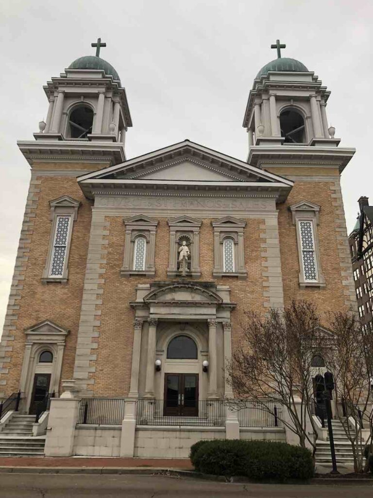
The majority of Paducah’s buildings do not reach the heavens with the exception of one building in the Tudor style and the magnificent Catholic Church of St. Francis de Sales.
Church of St. Francis de Sales in Paducah, Kentucky. Author’s collection.
I would suggest that a significant reason for this is that municipal functions were located on the edge of town in the middle of the 19th century and that trend was continued into the 20th century. In 1825, the first courthouse for McCracken County was built at Wilmington, Kentucky, before being located to Paducah in 1832. In 1861, the courthouse was moved to its present location then at the “edge of town” with the current courthouse having been built in 1943. (Wilmington was about two miles west of Paducah, but the county seat was moved due to persistent flooding.)
Closer to the Ohio River but not far from the courthouse is the city’s municipal building which was first opened in 1964. It is arguably the most significant city hall in the entirety of the Commonwealth.
The City Hall building was designed by Edward Durrell Stone who was one of the most significant architects of the 20th century. His mid-century municipal building was described as being in the New Formalism design and was completed in 1964. In 2015, Janice Rice Brother penned the following article as the city of Paducah was determining what to do with this architectural landmark.
Fortunately, the City Hall was rehabilitated and my visit to Paducah occurred as the renovation was underway. Following the completion of the structure’s restoration, it received multiple awards and accolades. It was also placed on the National Register of Historic Places. (Source: City of Paducah)
My time in Paducah was limited and ill-timed in the cold of winter when the sights and tastes I most wanted to experience were closed due to my Sunday-Monday timeline. Even so, I caught a glimpse of another Kentucky community with a lot to offer.
City Hall in Paducah, Kentucky. Author’s collection.
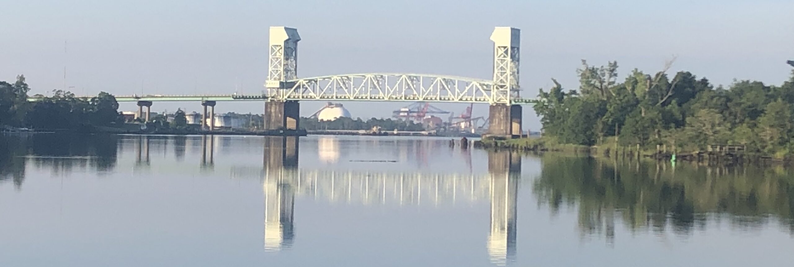
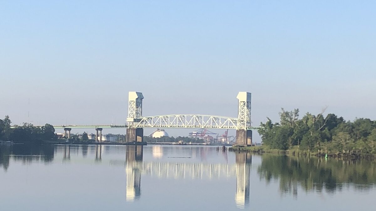
Cape Fear Memorial Bridge in Wilmington, North Carolina. Author’s collection.
I’ve had the opportunity to visit the Port City – Wilmington, North Carolina – several times over the past few years. It offers a busy and vibrant downtown, is the home of the University of North Carolina at Wilmington, and has nearby some beautiful beaches. Wilmington is nestled between the Cape Fear River and the Atlantic Ocean.
Wilmington also has a most troubled history. As a southern town, it almost goes without saying that the early economy of New Hanover County prospered because of slave labor. As a major port, railroads crossed North Carolina toward Wilmington where goods were exported around the globe.
Following emancipation and during Reconstruction, Wilmington continued to grow in prosperity. During the latter half of the nineteenth century, Black Republicans and their Fusionist allies saw the election of the city’s multiracial government. But underneath the success of progress, the sin of racism festered.
The Coup & Killings of 1898
White supremacists sought to defeat the elected multiracial government at the ballot box and to remove Blacks from power in Wilmington altogether. They threatened actions “by the ballot or bullet or both.” For months, the local newspaper had published misleading and outright lies in an attempt to divide the community and to incite white Wilmingtonians to fear their Black neighbors. On November 8, 1898, Democrats took every action imaginable to suppress the Black vote. Ballot boxes were stuffed with new ballots to the point where ballots far outnumbered the population.
But it was two days later, November 10, 1898, that the worst of the violence occurred. The Black-owned newspaper, the Record, was burned. Shots were fired in cold blood: at least sixty Black men were killed. Thousands more fled their homes and livelihoods; many were threatened to never return to the Port City upon threat of death.
I cannot even begin to fully lay out all that took place leading up to November 10, 1898, what took place that day, or what ensued for decades to come. I highly recommend David Zucchino’s Wilmington’s Lie: The Murderous Coup of 1898 and the Rise of White Supremacy to better understand this terrible chapter in our American history.
A report prepared a century after the coup concluded that the events of 1898 led “directly to strict residential segregation in Wilmington, decades of Jim Crow discrimination, and the disenfranchisement of the state’s black citizens.” Wilmington’s Lie at 341.
A Memorial to 1898
Even after several visits to Wilmington, I knew little of what had taken place here in 1898. (Which is why I took Zucchino’s book with me on an early trip there in 2020.) And I did not know that there stood a memorial to what had taken place.
Wilmington’s 1898 racial violence was not accidental. It began a successful statewide Democratic campaign to regain control of state government, disenfranchise African-Americans, and create a system of legal segregation which persisted into the second half of the 20th century.
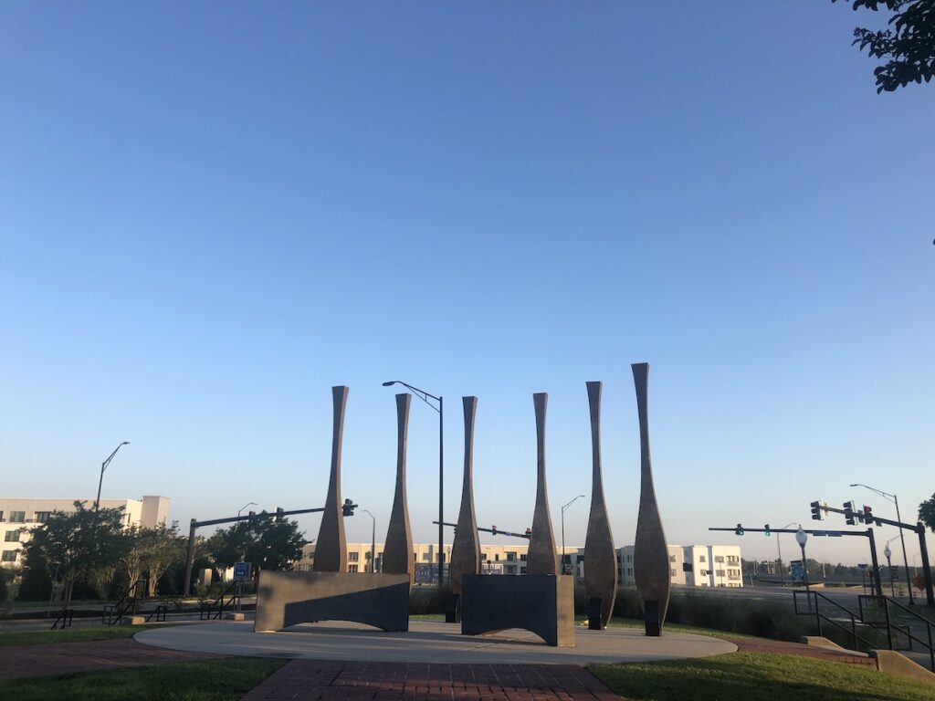
It would take Wilmington a century to recognize and begin the effort to memorialize “those who suffered as a result of the violence of November 1898.” An 1898 Foundation was established and, a decade later, the memorial was dedicated near the site where some of the worst violence occurred.
1898 Memorial in Wilmington, North Carolina. Author’s collection.
A plaque at the memorial reads:
These six bronze paddles stand as a memorial to those who suffered as a result of the violence of November 1898. The paddles refer symbolically to water, an important element in the spiritual belief system of people from the African continent. They believed water to be the medium for moving from this life to the next. Water is also incorporated into a diversity of beliefs throughout the world to symbolize purification, renewal, rebirth, forgiveness, cleansing and wholeness.
For this city that grew up beside the waters of the Cape Fear, these paddles symbolize a type of passage as well. The memorial stands here on the banks of this river as a testimonial to a community that, one hundred years later, strove to acknowledge injustices of the past and worked to move forward together towards a society of greater justice and inclusiveness for all its citizens.
We believe these slender yet strong paddles, though rooted in this soil of past memories, rise skyward to the future in a spirit of reconciliation and hope.
Members of the 1898 Foundation, 8 November 2008
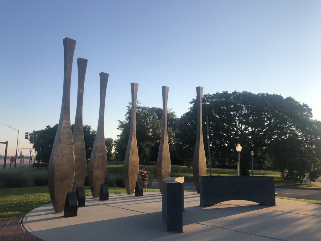
The 1898 Memorial in Wilmington, North Carolina. Author’s collection.
I visited the 1898 Memorial and learned about this horrible tragedy during the summer of 2020 while America again reeled from the killings of Black men and women. In the wake of these tragedies, Americans have again examined the importance of which people and events are memorialized, honored, and glorified. In Wilmington, North Carolina, police officers were fired after for “brutally racist” language. News of this broke as I departed Wilmington; when I returned home to Kentucky, two Confederate monuments were removed albeit for “safe keeping” in order to comport with laws passed by the North Carolina legislature to protect these kinds of monuments. And as with other Confederacy-glorifying monuments, the future of the two in Wilmington remains unclear.
I will not include photographs in this post of the two Confederate monuments which, for now at least, are in an undisclosed location. I bring them into this discussion only because, for a decade, they stood in Wilmington near the 1898 Memorial honoring completely two different things.
But as it states on the plaque to the 1898 Memorial, we ought to “move forward together toward a society of greater justice and inclusiveness for all its citizens.” It is a long, slow, but important road. And as Dr. Martin Luther King, Jr. said, “the arc of the moral universe is long, but it bends toward justice.”
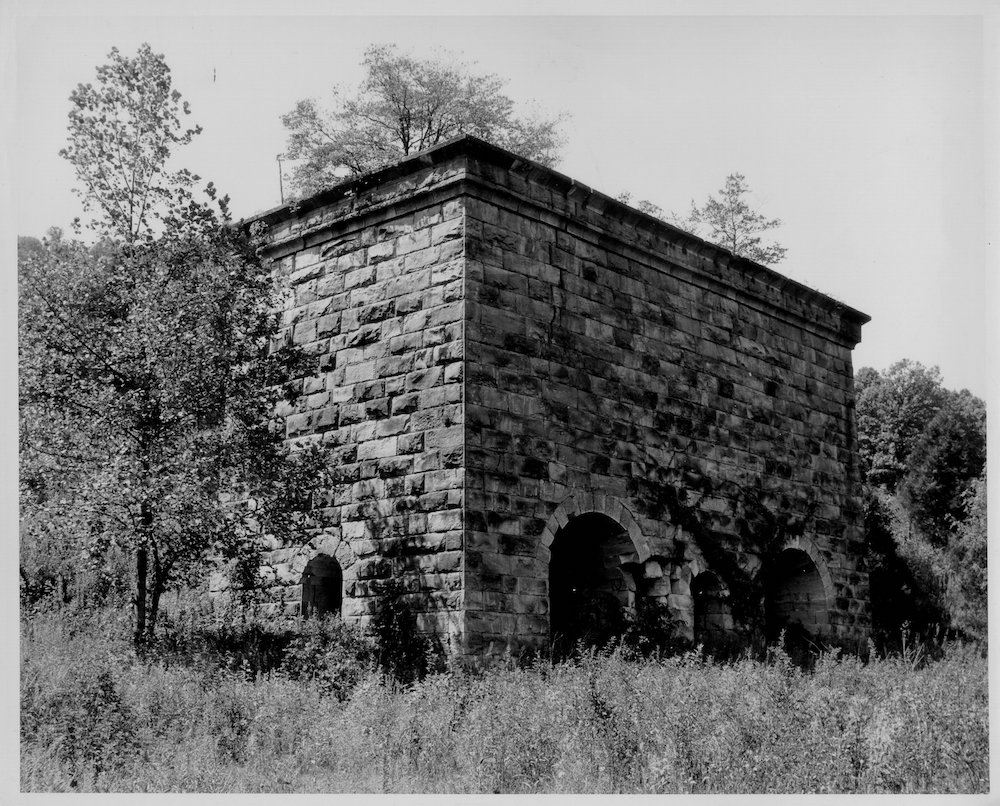
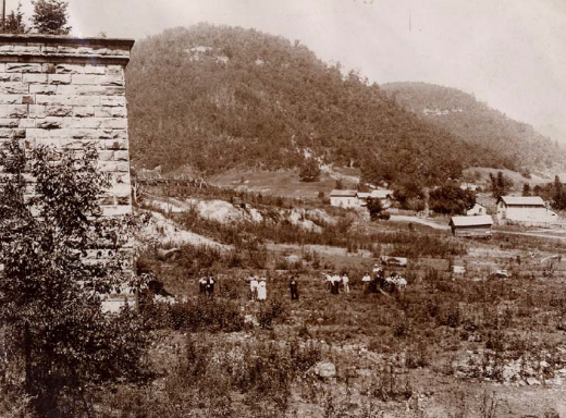
Fitchburg Furnace. University of Kentucky Libraries.
Nestled in the heart of the Daniel Boone National Forest is the Fitchburg Furnace – once the largest iron furnace in the world. Also known as the Red River Furnace, its twin stacks operated only from 1869 to 1873.
The Furnace and Fitchburg
In 1791, the first ironworks began operated in Kentucky. By the 1830s, Kentucky was the third-leading producer of iron in the United States. Throughout the commonwealth remnants of these furnaces dot the rural landscape. But the Fitchburg Furnace was significant if for no other reason than its scale.
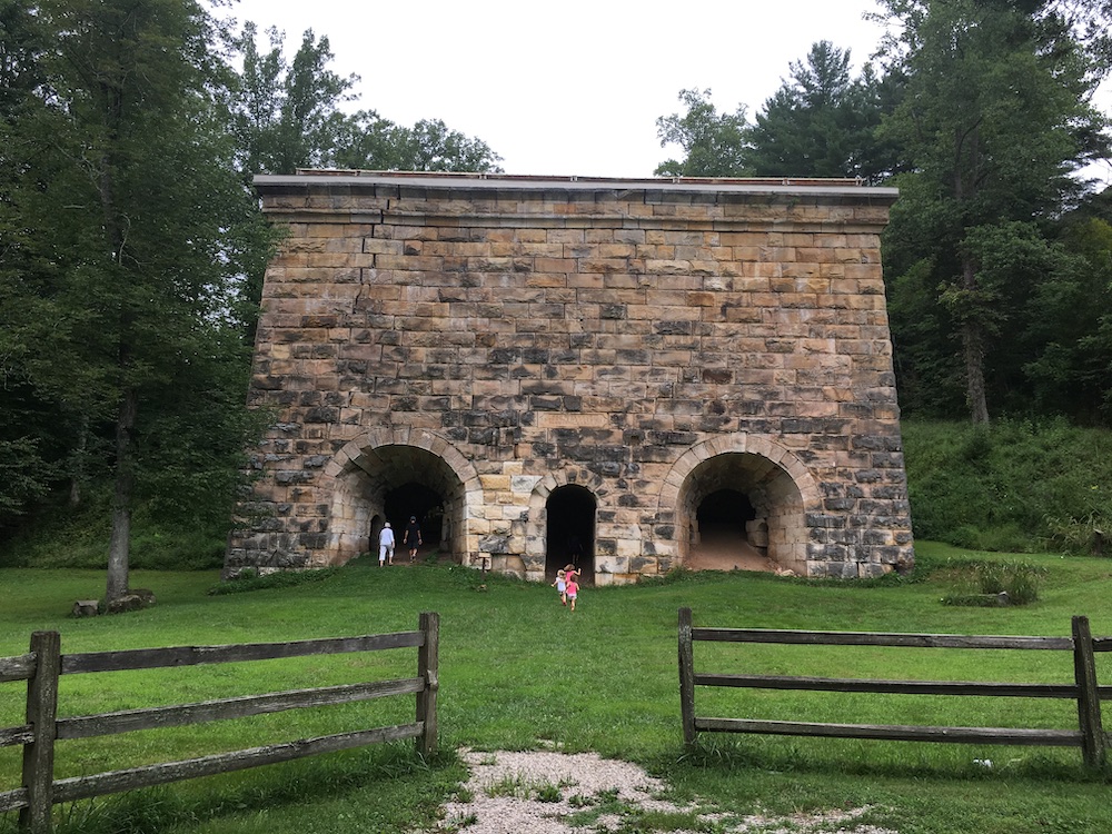
The furnace at Fitchburg is constructed of sandstone – its base forty by eighty feet. The structure stretches sixty feet into the heavens. Sixty feet may not seem like much, but the scale of this structure (150+ years old) in a rural part of Estill County is stunning. Although the furnace is all that remains of the iron-production operation, a powerhouse once flanked its rear while a casting shed stood in front.
The Furnace consisted of two twin stacks, while most Kentucky furnaces had only one. The stacks were named Blackstone and Chandler: each was fifty feet tall and 12.5 feet across on the inside. Together, the furnace could produce 25 tons of pig iron each day. Pig iron is an unfinished iron that requires further time in another furnace before becoming a usable product like wrought iron, cast iron, or steel. The pig iron forged at Fitchburg was shipped via flatboats to iron manufacturers in Cincinnati and beyond.
Brothers Frank Fitch and Fred Fitch developed the furnace when, in 1866, they established the Red River Iron Manufacturing Company. In 1867, Frank Fitch was quoted as saying that “I will design a furnace such as has never been seen before in these parts.” To accomplish this aim,
A furnace, however, does not stand alone. The power house and casting shed, too, are only a small part of the operation. At its height, over 1,000 people made up the community of Fitchburg to work at the furnace and to work in industries supporting, feeding, and taking care of those workers and their families. The community, of which today there is no physical evidence, once included stores and churches. It had a jail, a doctor’s office, and a hotel. In 1870, Fitchburg, Kentucky had approximately the same population as Nicholasville, Kentucky.
At this time in American history, railroads would begin to cross the nation. The first transcontinental railroad was finished by the driving of the golden spike at Promontory Point, Utah, around the same time as Fitchburg opened. Railroad companies and others invested in furnaces like Fitchburg and most of the iron from the furnace would have been utilized to produce rail and wheels for this industry.
Only a few years after the Fitch brothers opened their furnace, the bubble burst for railroad speculation. With that, the price of iron dramatically fell.
And if you’ve ever been to Birmingham, Alabama – the Pittsburgh of the South – you’ve undoubtedly see the statue atop a mountain to the Roman god of the forge, Vulcan. In the early 1870s, quality ore deposits were discovered in Alabama. It became far more efficient, and less expensive, to extract and forge iron in Alabama than from the hills of eastern Kentucky.
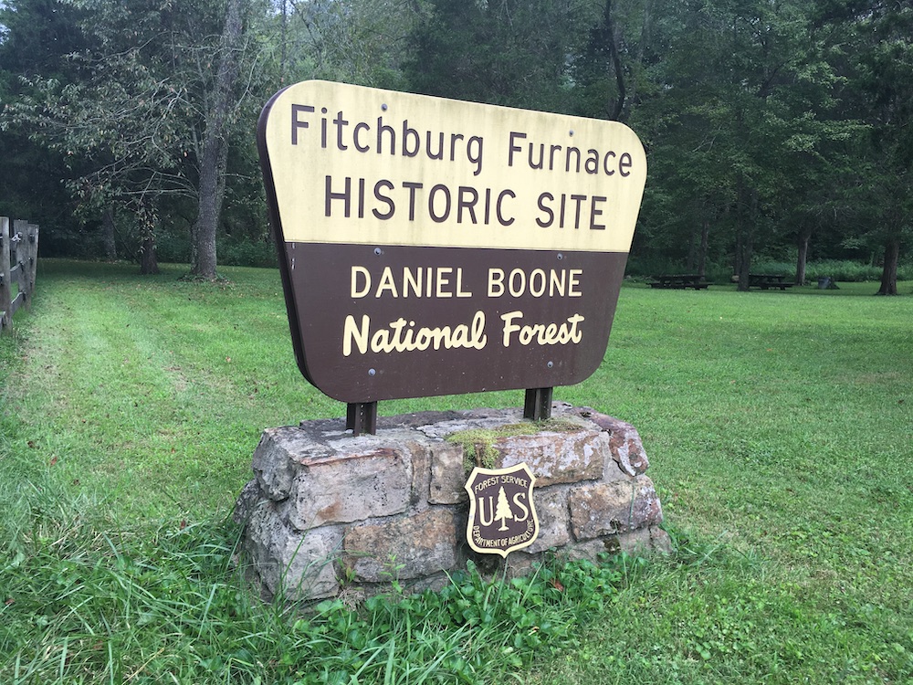
The Site Today
Even faster than it appeared, Fitchburg disappeared. The formidable stone furnace remained. By 1895, only the furnace and power house seemed to remain. In 1968, a US Forest Service employee began researching the site. Five years later, descendants of Frank Fitch donated the site – consisting now of only about two acres – to the United States Forest Service. It was added to the National Register of Historic Places the following year, 1974.
It was not until 2001 when there became a focused effort to restore the deteriorating structure. Reports indicated that the furnace itself (the only remaining structure) was within five years of a total collapse. Over the next decade, significant work was done to preserve this important piece of Kentucky’s industrial past.
Fitchburg Furnace. Author’s collection.USFS Signage at Fitchburg Furnace. Author’s collection.
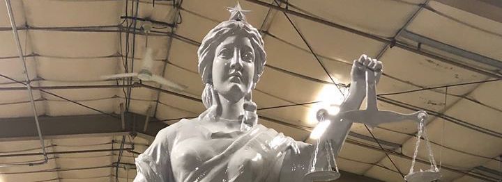
The scaffolding has recently been taken down from the courthouse in downtown Nicholasville as the Jessamine County structure’s significant renovation nears completion.
Part of the renovation included a complete restoration of the Lady of Justice statues which again stand atop the courthouse holding in her hand the scales of justice.
But the courthouse renovation should be viewed as incomplete. There remains one more item that requires completion: removal of the Confederate Monument.
A renovated Lady Justice before installation atop the courthouse. Doug Fain.
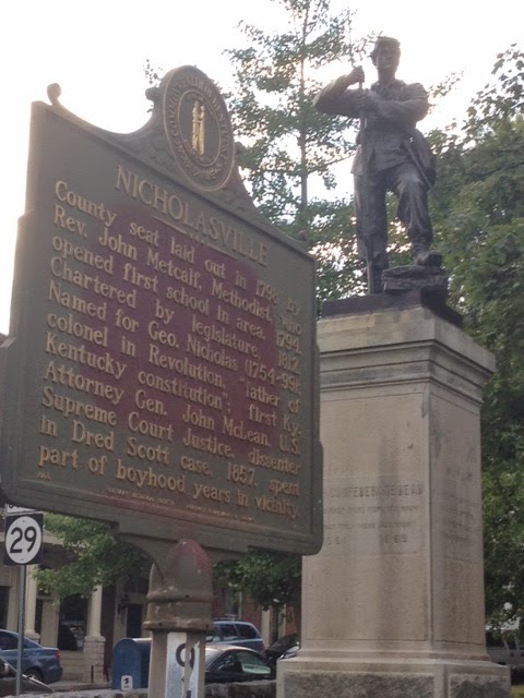
Jessamine’s Confederate Monument
The Confederate Monument standing on the courthouse lawn in downtown Nicholasville is significant and imposing. The seven-foot tall soldier stands upon an even taller 11-foot base. It is, by far, the largest monument at the historic courthouse.
The courthouse lawn, like the capitol in Frankfort, is a place where we honor and glorify. These are places where laws are written and enforced. Because we, as a nation, believe in equal justice under the law it is not right for our symbols in this important spaces to honor and glorify bias or prejudice.
So what does the Jessamine Confederate Monument honor and glorify?
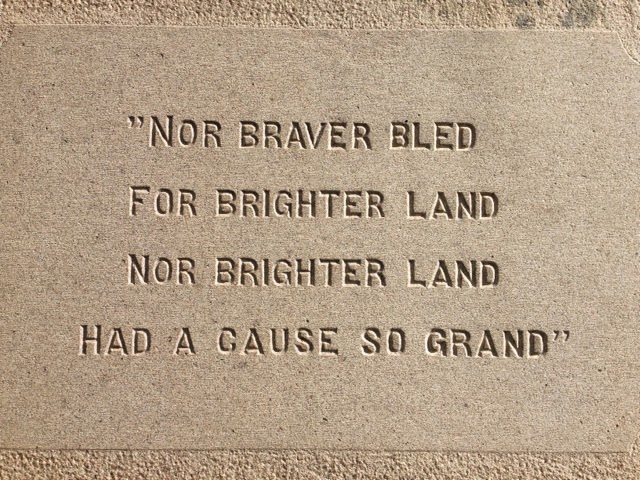
Its base contains various inscriptions which memorialize that ‘Lost Cause’ telling of history. Among the most offensive is this one: “Nor braver bled for brighter land nor brighter land had a cause so grand.” The words do nothing but glorify the South and the systemic racism with which our nation still struggles.
It does not belong on the lawn of a county’s seat of justice. It does not belong on the lawn of my county’s seat of justice.
Inscription on the base of the Jessamine Confederate Monument. Author’s collection.
Most curiously, the statue was originally that of a Union soldier to be located in an Ohio town. That town, however, could not raise the necessary funds. The Jessamine County association purchased the statue from the stone company for $1,500 and the belt buckle was modified from ‘USA’ to ‘CSA’.
As the largest monument at the courthouse, the glorification of the Confederacy (which fought against the United States) diminishes others who are honored for their service in the Revolutionary War. Other conflicts in which Jessamine Countians fought for the United States are not recognized by monuments on the lawn. Yet, those who fought against the United States receive oversized glory.
A Lynching at the Monument
The Confederacy stood to retain an economic system that enslaved Black Americans. Jim Crow kept a knee upon the necks of freed African-Americans after Reconstruction hurriedly ended with the Compromise of 1877. The Ku Klux Klan intimidated. Justice was denied and unequally applied. It is a stained history that America has not overcome.
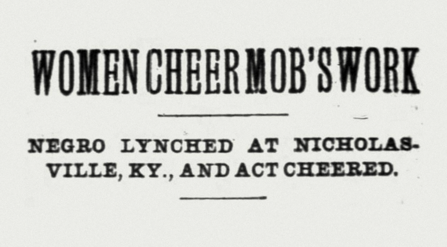
One of the worst symbols of this systemic mistreatment exists at the end of a rope thrown over the branch of a tree. Six years after the Confederate Monument was dedicated on the courthouse lawn and only feet away from that monument, a lynching occurred. The date was February 6, 1902. A 19-year-old black man, accused of assaulting a white woman, was seized by a mob of some 200 people from the local jail. On the courthouse lawn in the shadow of the Confederate Monument, the mob lynched Thomas Brown in Nicholasville, Kentucky.
When the monument was dedicated in 1896, it was done to memorialize the Confederate soldiers who had been disinterred from Camp Nelson and reburied at Maple Grove Cemetery just down Main Street in Nicholasville. It would seem altogether fitting for the statue to be relocated there to the cemetery.
Such a move would follow what happened in Lexington with the relocation of the John C. Breckinridge and John Hunt Morgan statues from the courthouse lawn to the Lexington Cemetery. As a result, the monument could still tell a history (hopefully one that has been appropriately contextualized), but in a place that does not cause the monument to function as a state-sanctioned glorification of the Confederacy.
The courthouse is a county-owned property and governed by the county’s fiscal court. Maple Grove Cemetery is city-owned. Both would need to consent to the relocation of the statue. And, of course, funding (or donated services) would need to be secured to remove and relocate the statue.
The monument is, however, protected by state law. The Kentucky Military Heritage Commission serves as the gatekeeper against any listed site being “damaged or destroyed, removed or significantly altered” without the Commission’s written consent. Removal of the statue, or relocation to Maple Grove Cemetery, would require approval from the Military Heritage Commission.
My own arc toward justice
First, I must make my own confession. In 2014, I wrote columns for The Jessamine Journal. In one, I recognized the statue without appropriate context. I didn’t fully consider the impact the statue might have on black defendant seeking their own justice. Or of the inherent discrimination standing in front of the very source of our county’s judicial system. The presence of the Confederate Monument on the ground contradicts the existence of Lady Justice on the roof. I should have, but did not, write the column you are now reading in 2015. Then, however, I called for the removal of the statues in front of the Fayette County Courthouse. I should have written a different column in 2014 and I should have written another in 2015; I regret having waited another five years to write this one. But today, I write that the Confederate Monument on Jessamine County’s courthouse lawn needs to be removed.
The article I wrote in 2014 quoted Col. Bennett H. Young. Young wrote the definitive history on Jessamine County in 1898 and was present at the 1896 dedication of the statue. He was a Confederate veteran who found the statue the “handsomest” in the county. Young was leading an effort to tell the story of the Confederacy, and all it stood for, through the innocent sounding ‘Lost Cause’ mantra.
Colonel Young had his own agenda, however. Though he wrote a definitive history for the county, his own past identified him as one who fought against the United States during the Civil War. By glorifying a ‘Lost Cause,’ he was part of the effort to rewrite history. It is now time to make sure that our history is properly told.
Today’s Jessamine County
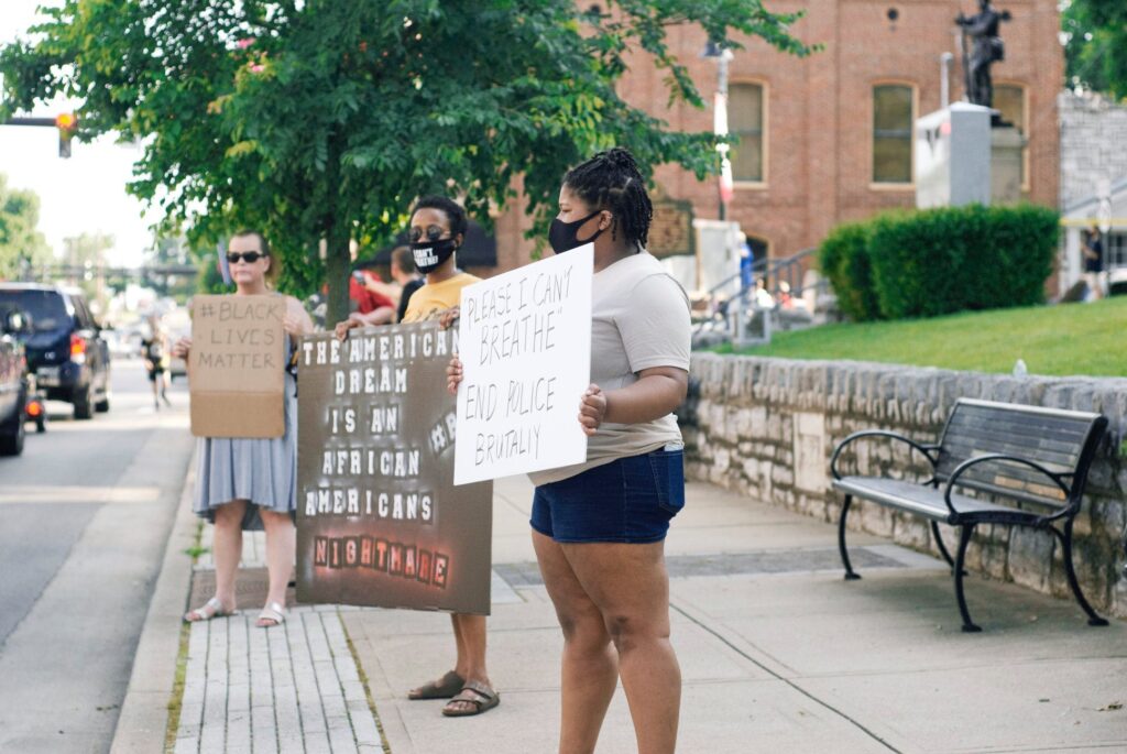
Last Saturday, a Black Lives Matter protest rally was held in front of the courthouse on Main Street in Nicholasville. This coming Saturday, similar events are being planned in both Nicholasville and Wilmore.
Across the Commonwealth, similar protest rallies are occurring in surprising places. The national and international rage over the murder of George Floyd, Breonna Taylor, and others is being felt here in Jessamine County. There is a sense of urgency to do what is right. In Jessamine County, one step toward righting centuries of wrong is to no longer glorify systemic racism in the heart of our city in front of the courthouse. The Jessamine Confederate Monument must be removed.
There will be opposition, some of it angry opposition, to the statue’s removal. The newly restored statue of Lady Justice must be the symbol of what we pursue in Jessamine County: that simple creed upon which our nation was founded “that all … are created equal.” Some opponents will say that history is being whitewashed by the statue’s removal; to the contrary, the ‘Lost Cause’ sought to revise history a century ago. The statue must be removed from the courthouse lawn because what it represents is not justice.
Black Lives Matter Rally in Nicholasville on 6 June 2020. The Confederate Monument is in the upper-right of the image’s background. Jessamine in the Raw.
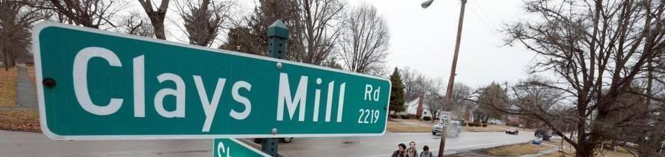
In a conversation with another local historian, I recently learned the location of Clays Mill.
The spokes out of Lexington each head somewhere. Harrodsburg Road goes to Harrodsburg. Nicholasville Road to Nicholasville. Old Frankfort Pike. Well, you get it. If you consider all the springs and creeks around our community, then consider all of the roads with names related to that lost topography and industry that has been covered with residential and commercial zoning and structures.
Armstrong Mill. Or Millpond. Which is close to Spring Run Road. Then there is Higbee Mill. But probably the most significant “mill” road in today’s Lexington is Clays Mill (historically written Clay’s Mill).
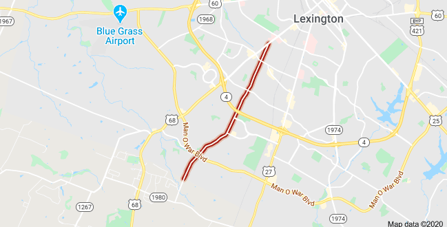
Clays Mill Road Today
Google Maps.
Clays Mill Road runs from Harrodsburg Road all the way into Jessamine County where it terminates at Brannon Road. The map above shows Clays Mill Road, in red, from where it begins to the Fayette-Jessamine County line. You can see just south of there where the road now terminates in Fayette County.
The road itself was once two-lane the entire distance until a proposal begun in 2002 led toward the road’s widening. The proposal was opposed by many neighbors because of the increased traffic and character change that would result from the project.
Another oft-mentioned project, once in the state’s six-year road budget, was the construction of an exchange from New Circle Road at Clays Mill. That project was “indefinitely delayed” in July 1985.
Clay’s Mill Road of History
But the Clays Mill Road of today (or even of 35 years ago) doesn’t answer the historical questions of the road. In 2003, it was posed in the Lexington Herald-Leader: “Did the Clay family own a mill for which Clays Mill Road is named and, if so, where was it located?”
It’s a good question. Newtown Pike ended in Newtown. When you drive out Richmond Road, you’d eventually arrive in Richmond. But driving out Clays Mill only takes you to Brannon Road.
The newspaper’s answer: “The Clay family mill was owned by Marston Clay and was sold to Samuel Barkley in 1803. The mill was located in Jessamine County on the Jessamine Creek near what is presently the end of Clays Mill Road where it connects to Brannon Road.”
Whoever wrote the answer for the newspaper clearly didn’t travel out Clays Mill Road. If they had, they’d discover that Jessamine Creek isn’t close to Brannon Road.
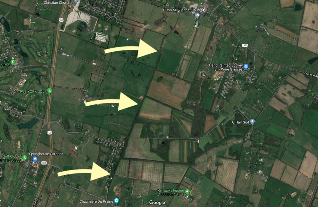
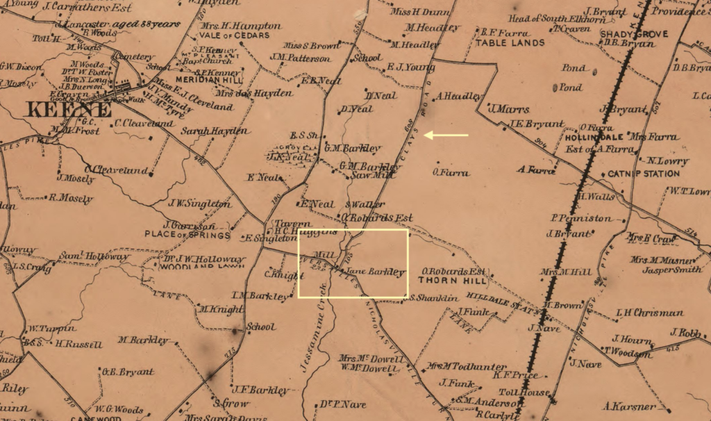
Thats because Clays Mill Road was once much longer than we think.
In the map above, the arrows point to a treeline which follow the old path of the Clays Mill Road. At the top of the map is Brannon Road and at the bottom is Catnip Hill Road in Jessamine County (you can see the reference to Chaumiere du Prarie at the very bottom of the map).
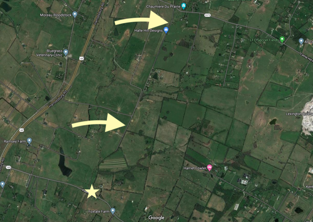
On the south side of Catnip Hill Road is a 1.6 mile road called Rhineheimer Lane. it is a straight shot almost the entire distance to KY-169/Keene Road in Jessamine County. The two yellow arrows in the map above point to Rhineheimer Lane. And the star — well, that is the site of the old mill. The old Clay’s Mill.
In the yellow square added to the 1861 map above, you can see the “Mill” adjacent to property identified as being that of Jane Barkley (which matches the newspaper’s account noted above). The small arrow points to another sign: Clays Road.
History Repeats Itself
Yes, I’m a history junkie. But I also like to follow the future growth of central Kentucky. As a result, I tend to read things like the Nicholasville-Jessamine County Joint Comprehensive Plan every time it updates. It was last updated in 2017.
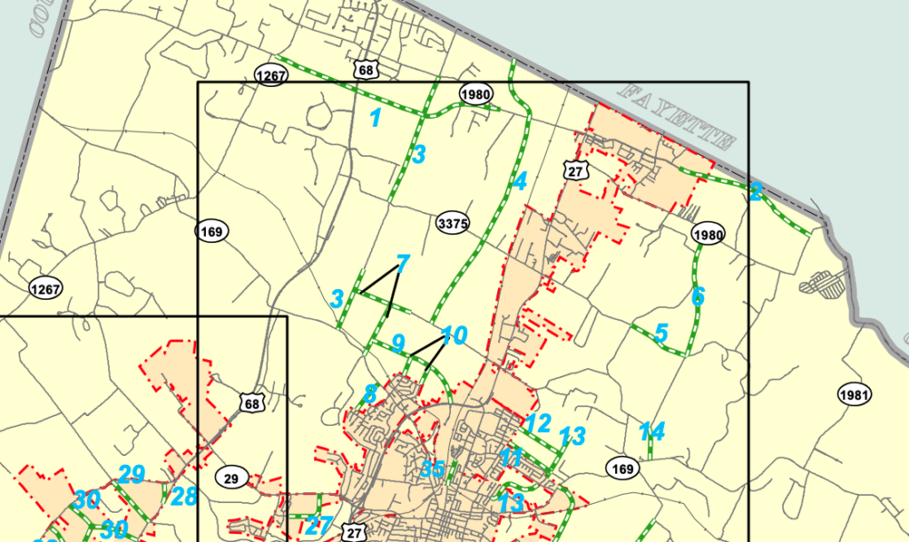
Buried on page 62 is information about a proposed “local connector road” is this potential future addition: “Begin at Clays Mill Road Extension south to meet Rhineheimer Lane at Catnip Hill Road; continue from south end of Rhineheimer Lane south to meet Keene Road.”
This proposed project is identified as “3” on the map below. (Another interesting project, “4” would extend Lexington’s Boston Road all the way to Baker Lane in Jessamine County. With these local connectors planned, you can anticipate a lot of residential growth in northern Jessamine County.
If/when completed, the old course of Clays Mill will once again run its full course. History has a funny way of repeating itself, doesn’t it?
Until last October, I’d never visited Bernheim Forest. Waiting so long was a mistake. For the uninitiated, Bernheim – officially Bernheim Arboretum and Research Forest – includes 16,137 acres of land in Clermont, Kentucky. It is located about 25 miles south of Louisville on land acquired by Isaac W. Bernheim in 1929.
The History of Bernheim Forest
Isaac and his wife, Amanda, had dreamed of creating an herbarium and arboretum. Amanda died in 1922, but Isaac carried out their shared vision. Isaac Wolfe Bernheim was born in Germany and immigrated to the United States. He arrived in this country with less than four dollars in his pocket and the dream of opportunity. The year was 1867, but he did not immediately find the success he had dreamt for. His uncle was not able to provide him with the work he had planned in New York. Isaac headed west as a peddler throughout Pennsylvania before landing in Paducah, Kentucky in 1868. There, he entered the wholesale liquor business as a bookkeeper.
In Paducah, Isaac Bernheim saved enough money to send home to Germany funds necessary for the emigration of his brother. Together, they opened Bernheim Brothers in 1872. Ultimately, a successor company relocated to Louisville in 1888. The company continued to grow and prosper; it did not shudder during Prohibition. With one of only ten licenses to produce bourbon for “medicinal purposes, Bernheim Brothers remained opened during The Great Experiment of 1920 to 1933.
During this season, Bernheim’s wife passed away and the land for the Forest was purchased. Frederick Law Olmstead began to design the park in 1931 on land that had been strip-mined of iron ore. The park opened in 1950.
To all I send the invitation to come from city, village, hamlet and farm, to re-create their lives in the enjoyment of nature and the many blessings she gives…
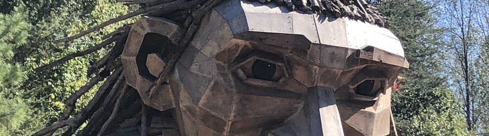
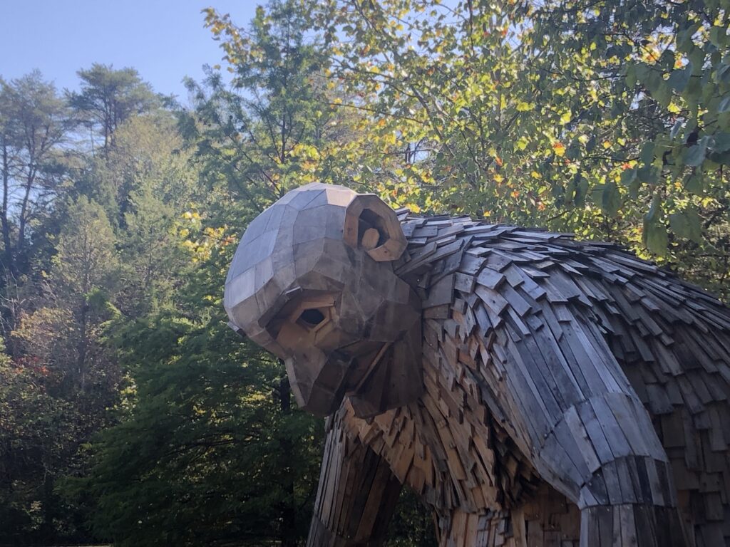
When I visited with my wife and three kids, we mainly arrived to see the Forest Giants. The Giants were constructed by a Danish artist, Thomas Dambo, using locally sourced recycled wood. The Giants are a family: Mama Loumari and her two children, Little Nis and Little Elinsa. Mama Loumari is depicted as pregnant with a third baby Giant in utero.
The Giants were introduced to Bernheim Forest in celebration of the 90th anniversary of Bernheim’s original land acquisition. You can view all of them in a relatively short walk/hike leaving much of Bernheim Forest unexplored. In total, there are some 40 miles of trails.
Since March 26, 2020, Bernheim has been closed due to the Coronavirus. Once it reopens, it will again be a fantastic place to socially distance. To learn more about Bernheim Forest, its reopening, and how you can support this important part of Kentucky’s greenspace, visit its website www.bernheim.org.
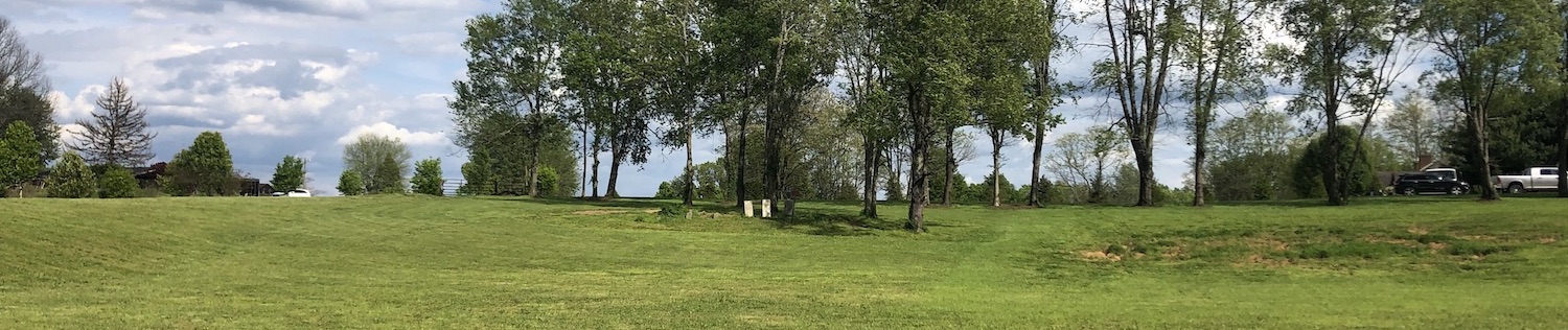
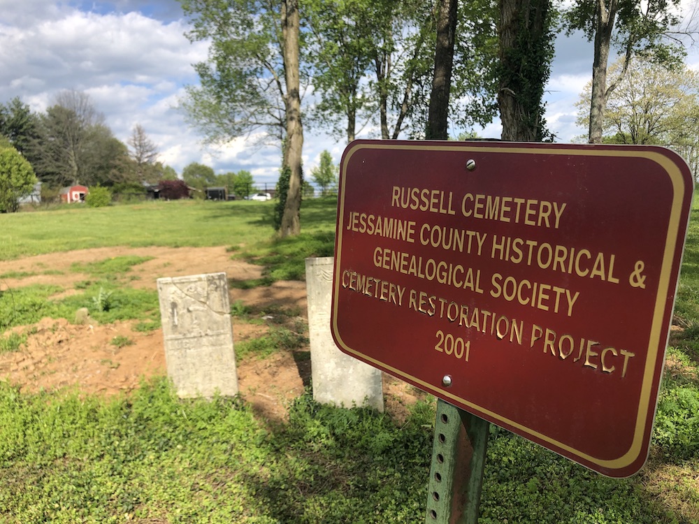
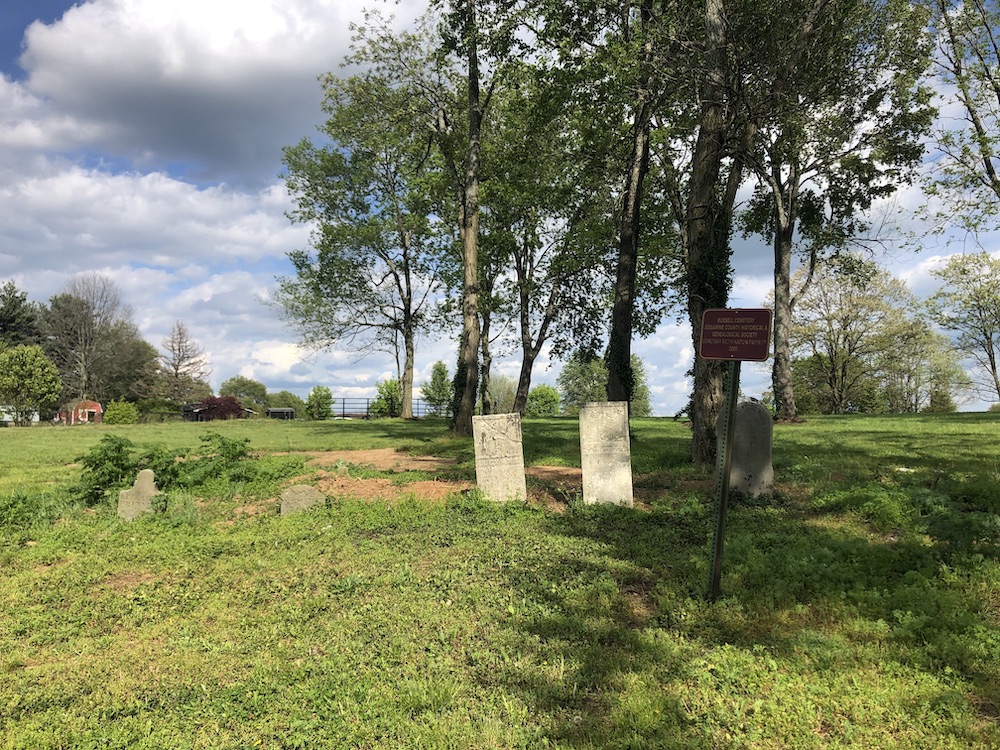
In 2001, the Jessamine County Historical Society helped to restore a historic family cemetery located in the county near the intersection of Highway 68 and KY 169. There are five identified graves in the cemetery according to the Society’s records.
Russell Cemetery. Author’s collection.
The Remains
There are five headstones identified at the Russell Cemetery:
Elizabeth McClanahan PREWITT (Dec. 13, 1787 – June 13, 1833)
Harvey PREWITT (1786 – May 1840)
Elizabeth Featherston RUSSELL, Age 80 years, Wife of Hezekiah (Unk – May 26, 1863)
Hezekiah RUSSELL (April 10, 1790 – October 24, 1872)
Lucy Ann SALE, wife of John (Feb. 15, 1822 – Sept. 2, 1858) [1][4]
The (Short) Backstory
The cemetery near the intersection of the two highways contains not just the Russell family remains, but it is a tangible reminder of history itself.
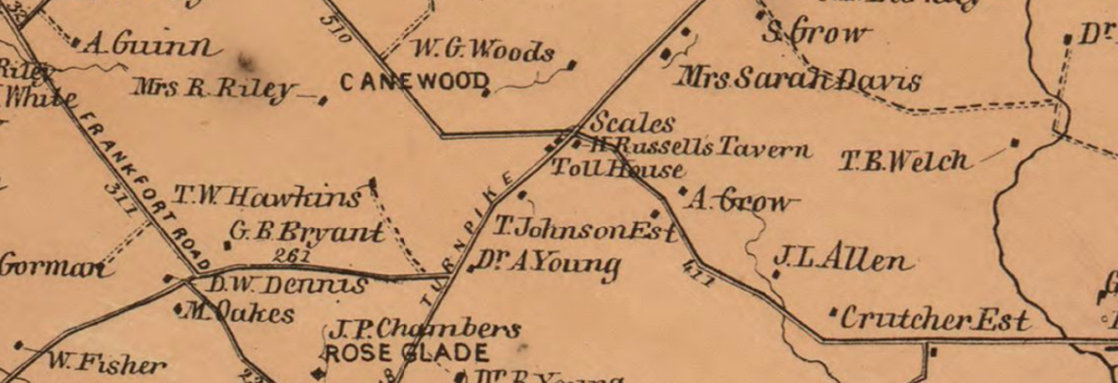
Russell’s Tavern at Russell’s Cross Roads
Hewitt’s 1861 Topographical Map. Library of Congress.
The map above shows a busy intersection at the onset of the Civil War. Near H. Russell’s Tavern was a tollhouse and scales where tolls were collected for those passing along the Lexington-Harrodsburg-Perryville Turnpike which was also known as Old Curd’s Road.
H. Russell’s Tavern was, of course, the tavern owned by Hezekiah Russell whose remains were buried at the Russell Cemetery following his 1872 death.
An archeological study conducted in the spring of 1999 uncovered “Hezekiah Russell’s mid-19th-century tavern and scales were also identified.” [2] The crossroads was historically referred to as Russell’s Cross Roads after the tavern.[3]
At some point before his death in 1840, Harvey Prewitt “operated the tavern at Russell’s Cross Roads.” Harvey Prewitt was born in 1786 in Halifax County, Virginia. His first wife, Elizabeth, is buried in the Russell Cemetery; they were wed in 1821. [5]
A Veteran of our Nation’s Independence
Harvey’s father, Byrd Prewitt, served in the Revolution, enlisting in Virginia “as a private in Capt. Henry Terrill’s Company, Col. Josiah Parker’s 5th Regiment.” [5] Byrd Prewitt served at the battles of Brandywine and Germantown. [6]
When he applied for a pension in the latter years of his life, he swore that he was “by occupation a farmer but from old age and infirmity can do but little that his wife is dead and that he now lives with his sons-in-law.” [7]
On July 4, 1794, Byrd attended a celebration at the nearby plantation of Colonel William Price; it was a gathering of veterans in the first celebration of our Nation’s independence to occur west of the Allegheny Mountains. [5]
Russell Cemetery. Author’s collection.
Sources
[1] Russell Cemetery. Rootsweb. [Online] Rootsweb. [Cited: May 7, 2020.]. [2]Society for Historical Archeology. 1999. Current Research. [ed.] Norman F. Barka. SHA Newsletter. 1999, Vol. 32, 3, p. 14. [Online]. [3]Hudson, Karen E. 1999.Canewood Farm, Jessamine County, Kentucky.: National Register of Historic Places, 1999. #99000494. [4] Russell Cemetery. Find A Grave. [Online]. [5]Prewitt, Richard A. Prewitt-Pruitt Records of Virginia. Des Moines: 1996 [Online]. [6]Bunch, Clyde N. 1999. Known Revolutionary War Soldiers of Jessamine County, Kentucky. [Online] January 11, 1999 [7]Prewitt, Byrd. 1828. Pension Application of Byrd Prewitt. [trans.] Will Graves. Southern Campaign American Revolution Pension Statements & Rosters. Lexington : 1828. [Online].
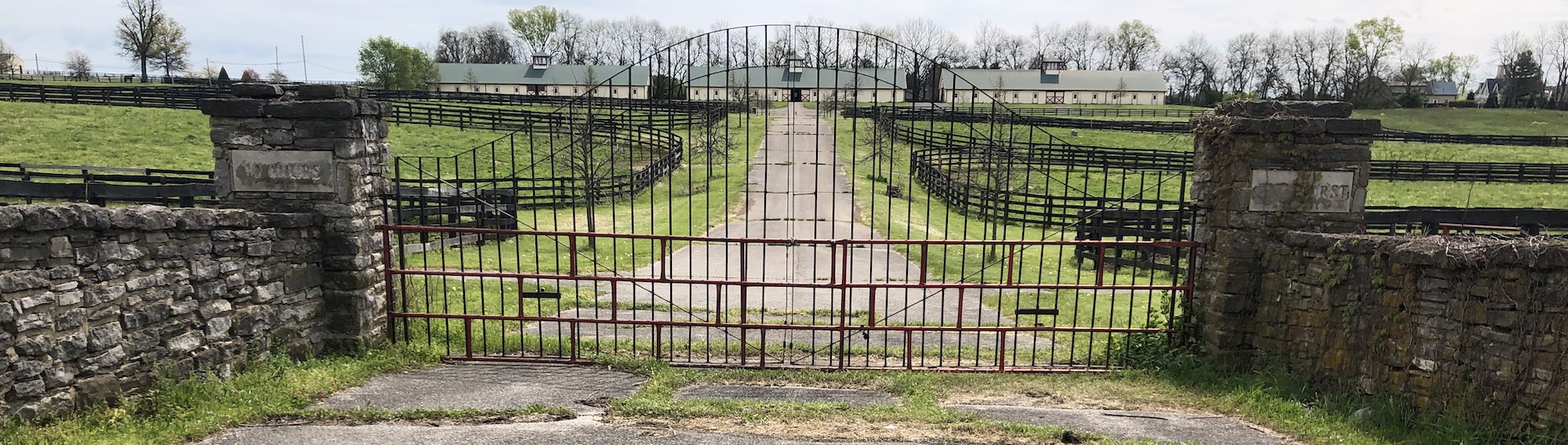
In 2010, a road project in Jessamine County completed the widening of a six-mile stretch of Harrodsburg Road. Before the project was completed, KY-169 didn’t cross Highway 68 at an intersection. Coming from the west toward Nicholasville, KY-169 seemed to dead end at Highway 68 (to continue, you’d turn right and then left to continue on KY-169). At that dead end was a historic marker – # 565 – noting the site of the “Almahurst Farm.”
A Missing Marker
Behind the historic marker was a beautiful stable which remains standing although now much further back from the road. That historic marker, however, seems to have never found its way back to the roadside. The historic marker reads
This is part of the original land granted to James Knight, 1750-1831, for his services in the Revolutionary War. A portion owned by his heirs in 1962. Among the famous horses bred, foaled, and raised on this farm were: Greyhound, world’s champion trotter of all times; Peter Volo, founder of one of the great trotting families; Exterminator, known wherever thoroughbreds are raced.
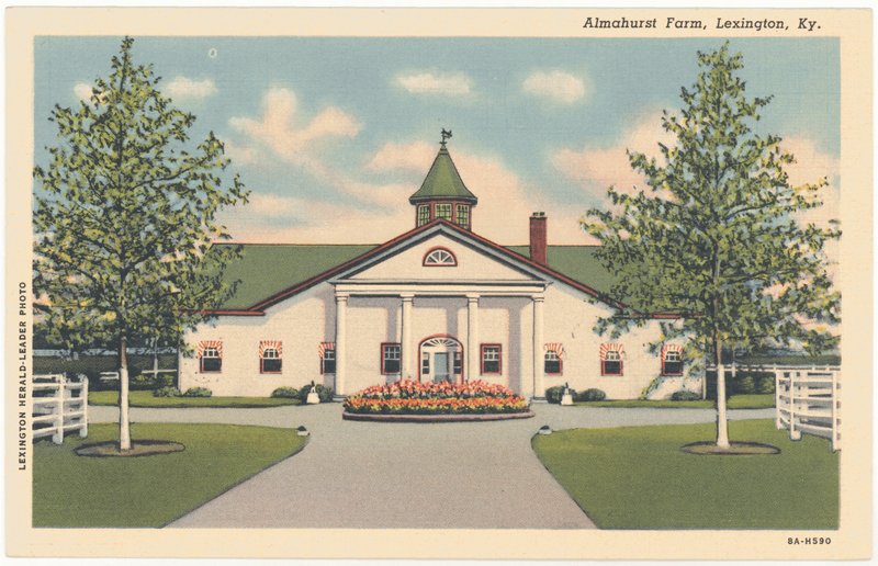
Postcard of Almahurst Farm. University of Kentucky Libraries.
During a recent bike ride along the old US 68 corridor, I thought of the old historic marker as I passed a metal gate between stone columns which bore the name of Almahurst. The Almahurst name, however, might not have been easily seen unless you were looking for the word as some of the letters etched into stone had been patched and filled. But it triggered my memory of that marker which I hadn’t seen in a decade. Another vestige of that old era is that the metal gate and columns are on a stretch of the old highway, just south of KY-169, that today is called Almahurst Lane.
I reached out to the folks at Ramsey Farm, the current property owner.[2] I learned from them that the historic marker remains! It stands at or close to its original location and if you look really closely from the trail, you can make out the marker’s iconic outline. They kindly shared with me this current photo of Historic Marker #565:
Almahurst Farm Historic Marker. Ramsey Farm.
The Knight’s and Exterminator
The original owner of record of the property was James Knight.[1] He received land grants for some 300 acres in 1783 and 1784 for his service during the Revolutionary War in the Continental Army’s Virginia Line. Ultimately, five generations of the Knight family would own the property before it was conveyed beyond the family. Grant Knight, James’ grandson and thus the representative of the third generation of Knights, had three sons: William, F.D. “Dixie,” and Grant Lee.[2] [3] Grant began the family’s equine love affair; his sons built upon the legacy.
Exterminator was the winner of the 1918 Kentucky Derby despite being a long-shot with 30-1 odds. Exterminator was bred by Dixie Knight out of Fair Empress, though the dam was owned by Dixie’s mother.[3] As a result, Dixie may have handled the paperwork on successful horse to his own mother’s discredit.
Knight sold Exterminator for $1,500 in Saratoga’s yearling sales; the buyer was Cal Milam. In the spring of 1918, Milam sold Exterminator to an agent for Willis Sharpe Kilmer. Soon thereafter, Exterminator won the 1918 Kentucky Derby. The gelding’s winning purses exceeded a quarter million dollars.[4] That’s nearly $3.7 million today![3]
Grant Lee Knight’s son, Henry Knight, acquired full ownership of the farm and gave it the name Almahurst. [3] Eventually, the farm ultimately included some 2,100 acres on which both thoroughbreds and standardbreds were raised. Despite its prominence, the Knights never engaged in racing.[3] In time, he would also parcel out portions of the farm to family while liquidating the rest. From the 1960s to the 1990s, P. J. Baugh owned the property and continued to breed standardbreds there.
Ramsey Farm
The property was purchased in 1994 by Kenneth and Sarah Ramsey. They renamed the property Ramsey Farm.
Though they gave the farm a new name, the Ramsey’s have expanded its legacy. Ramsey also owns racing thoroughbreds; according to the Lane Report, “their horses have just short of $95 million in winnings.”[5] They have expanded the property to over 2,000; in 2015, they also acquired the historic Chaumiere des Praries.
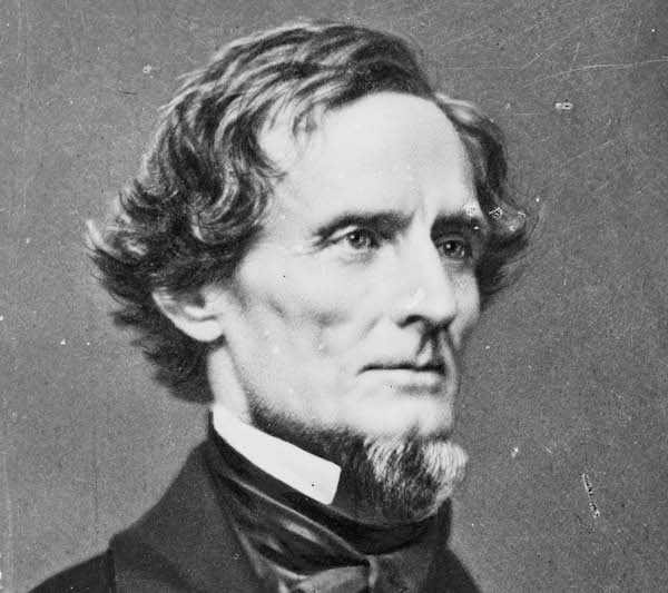
This post was originally written in 2015 and entitled “Jefferson Davis Gets His Citizenship Back”, but was updated in 2020 following the Historic Properties Advisory Commission voting 11-1 to remove the statue of Jefferson Davis from the rotunda of the Capitol. Changes are in bold.
It is not often that I review a book that came to print more than thirty years ago, but events of late have brought Jefferson Davis to the forefront of our national psyche. In Kentucky, we are asking whether a statue of Jefferson Davis should or should not be removed from the rotunda of the state capitol. In South Carolina today (2015), the Rebel flag is likely to be permanently removed from the grounds of the state capitol in Columbia.
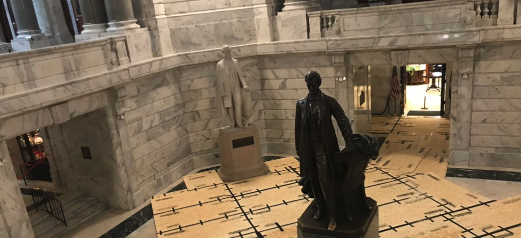
Back in Frankfort, Davis’ statue stands in a ring of four around a larger, central statue of Abraham Lincoln. The other three Kentuckians recognized in the statuary collection are Ephraim McDowell, Henry Clay, and Alben Barkley. That is, until Davis’ statue was removed. On June 12, 2020, the statue was removed following an emergency meeting of the advisory commission which oversees the rotunda. The recommendation and motion to remove the statue was made by the state curator, Carol Mitchell. Following discussion, the motion carried 11-1. The statue will ultimately be relocated to Jefferson Davis’ birthplace in Fairview, Kentucky, where it can be appropriately contextualized.
But it is the fifteen foot tall statue of Jefferson Davis that is drawing attention. The question and discussion is good: should Kentucky recognize and honor in her seat of government a man who was a traitor to the United States by leading a rebellion against the Union for the cause of enslavement of millions of Americans?
In considering the question, I wanted to better understand Jeff Davis. I turned to a book on my shelf that I had not before read: Jefferson Davis Gets His Citizenship Back. Written by Kentucky-native Robert Penn Warren, this 114-page short history of Jefferson Davis was first published in 1980.
Both Davis and Warren are natives of Todd County, Kentucky. In late 1978 and nearly nine decades after the former Confederate president’s death, Jefferson Davis’ U.S. citizenship was posthumously restored. Warren took the opportunity to recall Davis’ life and legacy which he intertwined with his own memories of Todd County.
It is in Todd County that the great obelisk to Jefferson Davis stands. The building of the obelisk in Fairview, Kentucky was begun in 1917 and suspended during the war effort (World War I). At the age of about twelve, Warren was driven by his family to see the construction site. His conflicted opinion of both Davis and the monument follow as he was unsure “about the mystery of the pain, vision, valor, human weakness, and error of the past being somehow transformed into, glorified into, the immobile thrust of concrete (not even the dignity of stone).”
By the time this construction had begun, the former Confederate president had been laid in the ground some twenty years earlier. In his life, Jefferson Davis served valiantly in the Mexican War leading a regiment of the Mississippi Rifles, most notably, at the Battle of Buena Vista. For his valor and success on the field of battle, President James K. Polk promoted Davis to the rank of brigadier general. But Davis “decorously [threw] back into [Polk’s] face with a lesson in constitutionality: no one but the governor of Mississippi could legally promote a colonel of the Mississippi Rifles.”
Davis’ commitment to states rights and to Mississippi were without doubt. The resurrection of such a commitment to the ideal with today’s Tea Party movement would have seemed odd to Robert Penn Warren, just as he observed the oddity of it 150 years ago:
How odd [the overemphasis on states’ rights] seems now – when the sky hums with traffic, and eight-lane highways stinking of high-test rip across hypothetical state lines, and half the citizens don’t know or care where they were born just so they can get somewhere fast.
Warren notes, too, that it was this commitment to state that, in part, might have cost the South the war. Just as the new colonies declaring their independence from England could not survive under the Articles of Confederation, the Confederacy was doomed because of its form. While Lincoln could order men to fight for the Union, Davis possessed far fewer powers when he served as President of the Confederate States.
It is the conflict of the man Jefferson Davis – his weakness, his ideals, his weak role in an institution that was structurally defective, his military success in the Mexican War, his personal love and loss – that make Robert Penn Warren’s book a beautiful story. And it is through the lens of history, circa 1980, that Warren makes what I think may be a profound point: if Davis “were not now defenseless in death, he would no doubt reject the citizenship we so charitably thrust upon him.”
The monetization of America would have distressed Davis (just as it would both Lincoln or Grant) such that Warren questioned whether any of these men would accept a “nation that sometimes seems technologically and philosophically devoted to the depersonalization of men? In a way, in their irrefrangible personal identity, Lincoln and Grant were almost as old-fashioned as Jefferson Davis.”
But in discussing Davis’ views on Lincoln’s emancipation of the slaves, Warren didn’t delve deep enough for our more modern lens. Davis was a slaveholder, true, but he believed in a lesser and a superior race thinking that it was a moral duty of the superior race to care for those in the lesser class. This omission leaves a chasm in the person of Davis. This superior-inferior representation and description by Warren went too far in restoring Davis to a better light than is appropriate.