In a conversation with another local historian, I recently learned the location of Clays Mill.
The spokes out of Lexington each head somewhere. Harrodsburg Road goes to Harrodsburg. Nicholasville Road to Nicholasville. Old Frankfort Pike. Well, you get it. If you consider all the springs and creeks around our community, then consider all of the roads with names related to that lost topography and industry that has been covered with residential and commercial zoning and structures.
Armstrong Mill. Or Millpond. Which is close to Spring Run Road. Then there is Higbee Mill. But probably the most significant “mill” road in today’s Lexington is Clays Mill (historically written Clay’s Mill).
Clays Mill Road Today
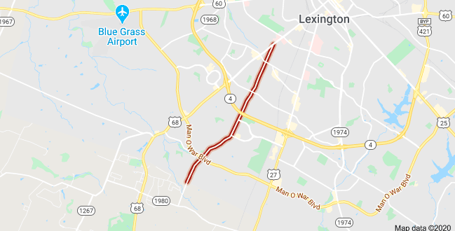
Clays Mill Road runs from Harrodsburg Road all the way into Jessamine County where it terminates at Brannon Road. The map above shows Clays Mill Road, in red, from where it begins to the Fayette-Jessamine County line. You can see just south of there where the road now terminates in Fayette County.
The road itself was once two-lane the entire distance until a proposal begun in 2002 led toward the road’s widening. The proposal was opposed by many neighbors because of the increased traffic and character change that would result from the project.
Another oft-mentioned project, once in the state’s six-year road budget, was the construction of an exchange from New Circle Road at Clays Mill. That project was “indefinitely delayed” in July 1985.
Clay’s Mill Road of History
But the Clays Mill Road of today (or even of 35 years ago) doesn’t answer the historical questions of the road. In 2003, it was posed in the Lexington Herald-Leader: “Did the Clay family own a mill for which Clays Mill Road is named and, if so, where was it located?”
It’s a good question. Newtown Pike ended in Newtown. When you drive out Richmond Road, you’d eventually arrive in Richmond. But driving out Clays Mill only takes you to Brannon Road.
The newspaper’s answer: “The Clay family mill was owned by Marston Clay and was sold to Samuel Barkley in 1803. The mill was located in Jessamine County on the Jessamine Creek near what is presently the end of Clays Mill Road where it connects to Brannon Road.”
Whoever wrote the answer for the newspaper clearly didn’t travel out Clays Mill Road. If they had, they’d discover that Jessamine Creek isn’t close to Brannon Road.
Thats because Clays Mill Road was once much longer than we think.
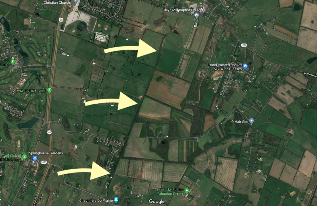
In the map above, the arrows point to a treeline which follow the old path of the Clays Mill Road. At the top of the map is Brannon Road and at the bottom is Catnip Hill Road in Jessamine County (you can see the reference to Chaumiere du Prarie at the very bottom of the map).
But that’s not all folks!
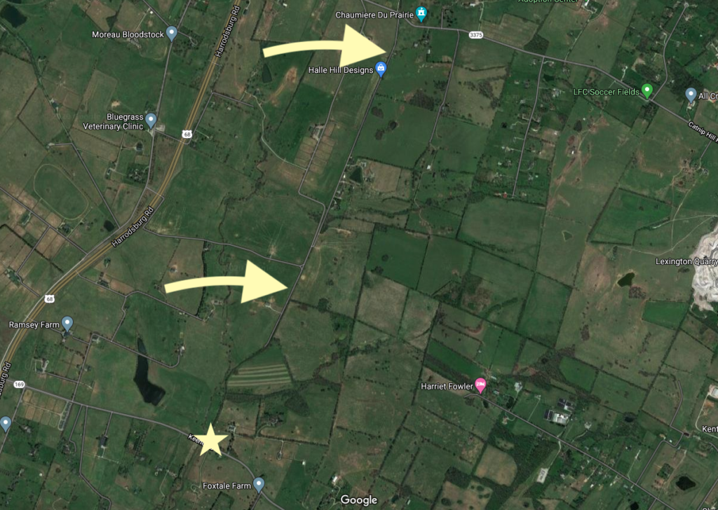
On the south side of Catnip Hill Road is a 1.6 mile road called Rhineheimer Lane. it is a straight shot almost the entire distance to KY-169/Keene Road in Jessamine County. The two yellow arrows in the map above point to Rhineheimer Lane. And the star — well, that is the site of the old mill. The old Clay’s Mill.
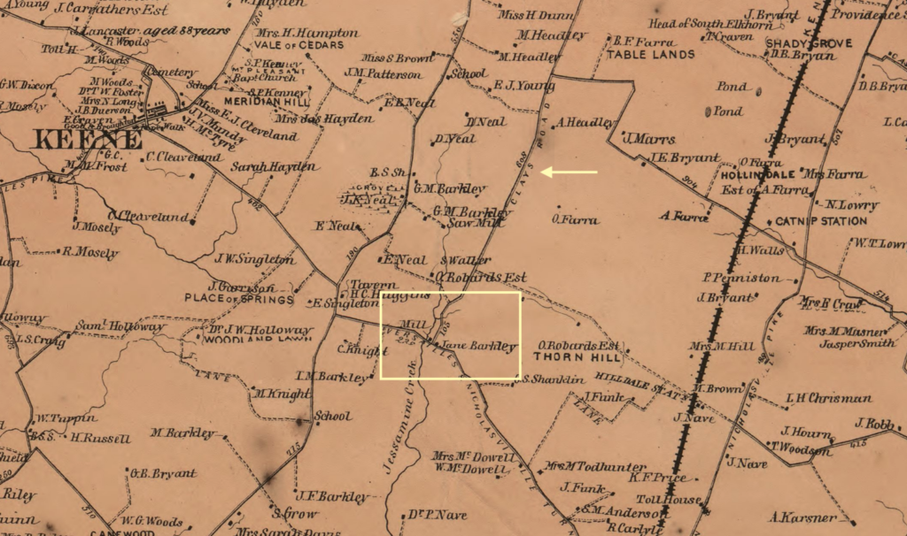
In the yellow square added to the 1861 map above, you can see the “Mill” adjacent to property identified as being that of Jane Barkley (which matches the newspaper’s account noted above). The small arrow points to another sign: Clays Road.
History Repeats Itself
Yes, I’m a history junkie. But I also like to follow the future growth of central Kentucky. As a result, I tend to read things like the Nicholasville-Jessamine County Joint Comprehensive Plan every time it updates. It was last updated in 2017.
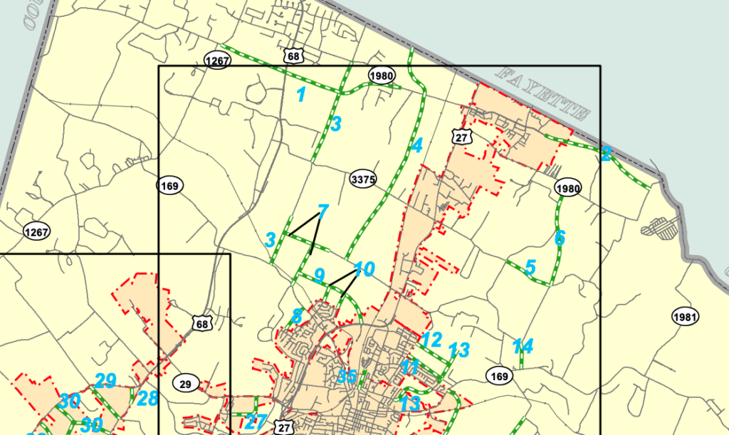
Buried on page 62 is information about a proposed “local connector road” is this potential future addition: “Begin at Clays Mill Road Extension south to meet Rhineheimer Lane at Catnip Hill Road; continue from south end of Rhineheimer Lane south to meet Keene Road.”
This proposed project is identified as “3” on the map below. (Another interesting project, “4” would extend Lexington’s Boston Road all the way to Baker Lane in Jessamine County. With these local connectors planned, you can anticipate a lot of residential growth in northern Jessamine County.
If/when completed, the old course of Clays Mill will once again run its full course. History has a funny way of repeating itself, doesn’t it?