NoD: Where will Newtown Pike take you? Newtown, of course!

Newtown, Kentucky
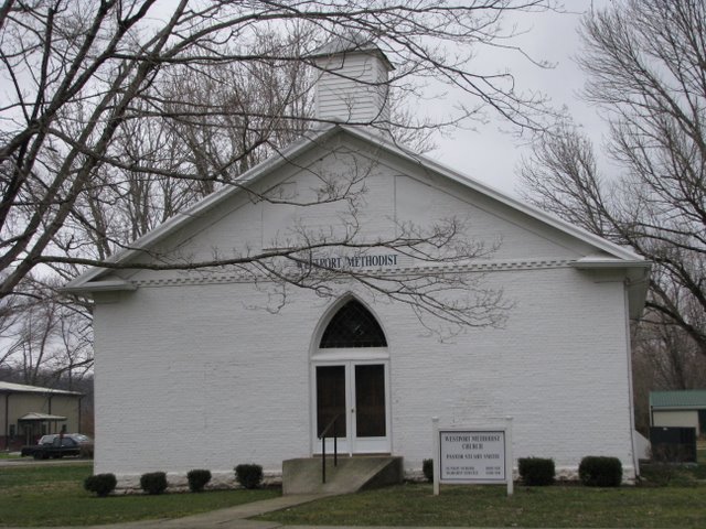
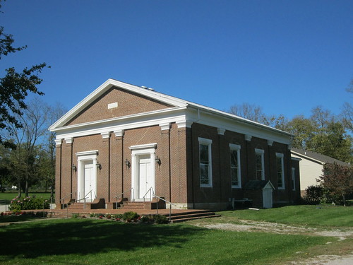
Newtown Christian Church – Georgetown, Ky.

When visitors (or my wife) get lost in Lexington, I am also befuddled. Lexington is designed as a wheel with spokes. Each of these spokes points to the downtown core passing New Circle Road along its way.

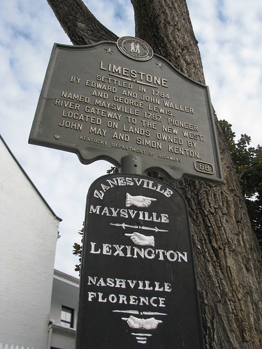
To make matters simpler, each of these roads is named after the next city along the way. Nicholasville Road. Harrodsburg Road. Paris Pike. Winchester Road. Richmond Road. Though some of the towns for which they spoke roads are named are not so obvious unless you are a local cartographer or history buff.

In fact, it was not until recently that I learned the origin of Newtown Pike. Yes, a drive down Kentucky 922 will take you through a beautiful, historic part of Fayette County before crossing into Scott County and depositing you at a junction with US 460. There the little hamlet of Newtown awaits with the same baited breath that it held over one hundred years ago. Which is another way of saying that Newtown has not changed much since it was first settled, which is believed to be in the 1780s. That’s right. There isn’t much “new” about Newtown.

The most impressive structure, the Newtown Christian Church (Disciples of Christ) is pictured above. The congregation dates to 1856 and was organized by Elder John Gano; the brick sanctuary was completed in 1857. Newtown also was the home to both Methodist and Presbyterian congregations according to town’s best authority: a history completed in 1882.

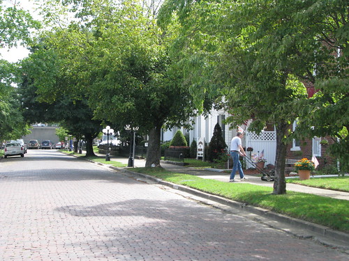
Today, the church is in fair condition. Several houses are nearby and an abandoned store is across the Paris Pike (US 460). A short distance toward Georgetown is a well-kept general store to which I hope to return.

But this is the end of the spoke that is Newtown Pike – a completed tale in the wheel of Lexington.

But, to disclose, I do have great sympathy for those visiting Lexington, as well as my wife. No town should have a St. Ann Street that becomes Fontaine that becomes Euclid that becomes Avenue of Champions before becoming Winslow. Yes, Lexington is a confusing mess of roads. But the wheel and spoke design is easy to understand if you just try.

NoD: Limestone (n/k/a Maysville)

Maysville, KY
Waymarking Sign, Maysville, Ky.

Lexington’s Limestone Street travels north to merge with Paris Pike and its history is there forgotten. Ultimately, you can take the road all the way to the Ohio River at Maysville. And Limestone Street was once aptly named since Maysville was formerly known as Limestone. Limestone was first settled in 1784, the road to Lexington (an old buffalo trace) was almost immediately established. [*]

In 1787, Limestone was formally established by the Virginia General Assembly which changed the name of the community situated at the confluence of Limestone Creek and the Ohio River to Maysville. At the time, Limestone/Maysville was part of Bourbon County (and was until Mason County was created in 1789) and was a key riverport for the bourbon whiskey industry.

By 1833, Maysville was a thriving riverport and was made the county seat of Mason County in 1848 (it was a contentious vote, as Washington was previously the county seat). The name “Limestone” was used to identify the community until the mid-nineteenth century as well.

No Destination: Catlettsburg

Catlettsburg, Ky.
Catlettsburg, Ky.

The population of Catlettsburg is only two-thirds of its size as of the 1900 census. As the county seat of Boyd County… wait? I thought Ashland was the county seat of Boyd County. It’s not? No. It is actually Catlettsburg.

Confusion aside, the location of Catlettsburg is strategic being located at the confluence of the Big Sandy and Ohio Rivers. It was a home of the U.S. District Court for the Eastern District of Kentucky from 1911 until 1985. The population also declined to “urban sprawl,” which is not a concept you would think of when you think of a hamlet of 1,800 (within the city limits, but Catlettsburg’s ZIP code has a population of about 10,000). But in the 1960s and 1970s, the realignment and expansion of US 23/60 through the area prompted the removal of many residential units which were never replaced.

Catlettsburg was a major timber market in the late 19th century and as a result there are very few trees. I selected the picture above because it was one of the few tree-lined streets I noticed in the central area. It also featured homes (though many were converted to commercial use) which were, as noted above, an anomaly. For more of my Catlettsburg pictures, check out Flickr.

No Destination: Georgetown

IMG_3382
Downtown Georgetown, Kentucky

I’ve already mentioned a number of locations in and around Georgetown – the College, the Japanese Garden, Ward Hall – but I haven’t discussed Georgetown itself. Originally named Lebanon, the town was renamed after George Washington in 1790 (present day Lebanon, Ky. wasn’t named until 1815).

Although founded by Rev. Elijah Craig and his fellow Baptists, its modern history goes back a little further. In 1774, John Floyd led the first whites into the area during a surveying expedition. Floyd and his men discovered the Royal Spring (which was Georgetown’s primary water source for years). Although Floyd claimed the surrounding 1,000 acres, he never settled the land. John McClelland began establishing a fort in April 1775, but the site was abandoned after an Indian attack in 1776. The white man did not return until Elijah Craig came in 1782.

The community remained a sleepy neighbor to nearby Lexington for many years. Georgetown, however, grew drastically when Toyota located its North American manufacturing facility here. Most notably, all Toyota Camry’s are manufactured in Georgetown. The town is also the home of the Cincinnati Bengals’ summer training camp.

Pictured is the downtown business district, called the Oxford Historic District. It is known for its beautiful examples of late Victorian and Greek Revival architecture. Check out all of my pictures of Georgetown on flickr.

No Destination: Historic Midway

Midway, Kentucky

Midway, Kentucky is a bustling town in Woodford County. The land that would become Midway was purchased in 1835 by the Lexington & Ohio Railroad Company. Located “midway” between Lexington and Frankfort (and also “midway” between Versailles and Georgetown), the town was Kentucky’s first railroad down. Of course, its location as a great crossroads was already known from the importance of the nearby Offut-Cole Tavern. And a train still travels through the middle of town on Railroad Street (unlike LaGrange, the train doesn’t impede parallel traffic)

Historic Midway has so many stories, and it has many historic markers on its Railroad Street that shares those stories:

“Sue Mundy” Here, Marker 537:

Jerome Clarke, called Sue Mundy, one of Morgan’s Raiders, formed his own guerrilla band on Morgan’s death Sept. 1864. Clarke and band raided here November 1, 1864, killing Adam Harper. Four Confederate prisoners executed in reprisal by Union forces. On Feb. 2, 1865, Clarke returned with William Quantrill, another guerrilla leader, burned depot here and stole 15 horses.

 Edward Dudley Brown (1850-1906), Marker 2027:

This well known African American horse owner, trainer, developer, and jockey was born into slavery, 1850. Raised as a stable boy near Midway, he was nicknamed “Brown Dick” after the record-setting racehorse of that name. Brown was associated with great horses such as Asteroid, Ducat, and Kingfisher. Presented by City of Midway and the Ky. African American Heritage Commission.

(Reverse) Noted Horseman – “Brown Dick” worked with Kentucky Derby winners Baden Baden (1877), Ben Brush (1896), and Plaudit (1898). He died at a friend’s house in Louisville, May 1906, of tuberculosis and was returned to Midway for burial. He was inducted into National Museum of Racing’s Hall of Fame on August 8, 1984. Presented by City of Midway and the Ky. African American Heritage Commission. 

 Midway, Marker 1580

First Kentucky town established by a railroad. In 1831, Lexington and Ohio Railroad Co. began railroad between Lexington and Frankfort and first train reached midway point, 1833. John Francisco farm bought by L&O in 1835; town of Midway laid out by R. C. Hewitt, civil engineer for railroad. Many streets named for L&O officials. Midway incorporated, 1846, by Ky. legislature.

Morgan at Midway, Marker 516:

Taking 300 abandoned USA horses and mules at Versailles, Morgan’s Raiders came here July 15, 1862. Advised of troop train approach from Frankfort he had tracks torn up and howitzers set. Train warned and returned to Frankfort. Morgan took telegraph line and coaxed train at Lexington to come on but it turned back. He and his men reached Georgetown that evening.

Besides its fascinating history, Midway is also the home to several great restaurants and antique shops.

No Destination: Pleasureville

Pleasureville Christian Church. Irony in the name? Perhaps.

Straddling the line of Henry and Shelby counties is the community of Pleasureville. The community first began under the name Bantaville when the area was settled by Dutch Huguenot families, including that of Abraham Banta, leaving Mercer County.

The source of the current name, Pleasureville, is believed to come from the presence of the community’s popular bordello (a source of pleasure, and likely of disease, for many).

I saw Pleasureville on the map and had to stop. Not since Preachersville have I found the name of a Kentucky community so unique. And obviously for quite different reasons!

No Destination: New Castle

New Castle, Kentucky

Marketed as “life in the s-l-o-w lane,” New Castle was founded in 1798 and incorporated in 1817. It has always been the county seat of Henry County. From its website:

The view from this Henry County “seat” hasn’t changed much in 200 years. Local traditions linger , even with Louisville just 35 minutes down the road. New Castle (pop. 919) is one of the smallest towns in Kentucky certified in both “Renaissance on Main” and “Preserve America” programs; we tend to our town with the same grit and teamwork it takes to farm. Nothing fancy here–a busy courthouse square, a few characters and a lot of lawyers (15 at last count.).

So in the past 200 years, not much has changed in New Castle. Except that there are more lawyers.  As for the origin of the town’s name, it is unknown. (Per Wikipedia and, more importantly, the Kentucky Encyclopedia.) I would suggest it is named after my favorite beer, Newcastle Brown Ale. The ale, however, wasn’t created until 1927 so I doubt that is correct.

No Destination: Carrollton

Carrollton, as viewed from the Observation Deck at General Butler State Park

Port William, Kentucky became the county seat of Gallatin County when the county was formed in 1799. In 1938, the county was divided to create Carroll County. At that time, Port William was renamed Carrollton with the new county and its seat being named after Charles Carroll (a signer of the Declaration of Independence from Maryland). Upon the death of Thomas Jefferson and John Adams (both died on July 4, 1826), Carroll was the last remaining signer. He died in 1832. [cite and cite]

Carrollton is a nice river town with a beautiful courthouse. The walk approaching the courthouse is tree-lined and quite stately. Much of Carrollton/Port William’s early history centered on Water Street. This street, located between Main Street and the Ohio River, is largely washed away due to changes in the path of the river.

In fact, much of downtown Carrollton was submerged during the flood of 1884: “[t]he swelling continued, and by Thursday evening the north half of the Court house yard was deep enough to row a boat in.” [cite] For those who haven’t been to Carrollton, let me give some perspective. The remains of Water Street are perhaps 18 inches above the river; Main Street runs parallel to Water Street but is probably twelve feet higher in elevation. The ground rises across Main Street, on the south side of which rests the courthouse. And the lawn is large. This was a big ol’ flood.

No Destination: Westport

The Old Courthouse in Westport is now Westport Methodist Church.

Along the Ohio River in Oldham County lies Westport. Westport’s layout and design are very unique as it is designed around a large commons – a grassy area reminiscent of colonial New England. In fact, I imagine that walking through Williamsburg, Virginia pre-Rockefeller’s restoration was similar to walking through Westport. I am not the only person who has experienced this kind of feeling after experiencing Westport.

The streets, the buildings, and even the trees themselves seem to cling proudly to the importance that was theirs in the time of flourishing river traffic. For it was the river that gave birth and life itself to the town.

–from “Westport” by Helen Fairleigh Giltner, 1947 [Source: Courier-Journal]

Today, the historic structures are in various states of repair/disrepair, but the Friends of Westport are working tirelessly to restore this little hamlet. Their current project is the Westport Schoolhouse.

Westport Schoolhouse

The Westport Schoolhouse, pictured at left, was erected in 1882 and is the only remaining one-room schoolhouse in the state that sits on a town square. The renovation, which is at risk due to state budgetary issues, would result in a community center for arts and education. [Source: WAVE3]

Baptist minister Elijah Craig, now of bourbon fame, received from Virginia a 300 acre land grant in 1780. His grant included Westport. When Oldham County was carved from Shelby County in 1823, this rivertown was named the county seat and served in that capacity until 1838 when the county seat was permanently moved to La Grange (with the exception of about a month in 1827 when La Grange was selected by voters as the county seat, but state officials soon thereafter returned Westport to the position of prominence under political pressure). When county governance left Westport for good in 1838, the courthouse (pictured at top of post) was deeded to the Baptist, Christian, Methodist and Presbyterian churches. The courthouse still stands today and is utilized by the town’s Methodist congregation.

No Destination: LaGrange

Main Street in historic La Grange, Kentucky

As Nate alluded to last week, we visited Oldham County’s seat a few weeks ago. Founded in 1827, this community community was not incorporated until 1840. Named for the home of General Lafayette (the Château de la Grange-Bléneau), some suggest that LaGrange is severely haunted and may be part of the so-called “Fayette Factor.” (An anomaly that I’ve discovered and intend on researching at length.).

DeHaven Baptist Church

I think what stands out about La Grange is that it remains a thriving community. Despite a population of less than 5,700 (2000 Census), La Grange’s downtown is filled with active and successful businesses. Remarkable for a town of its size, particularly in our current economic downturn. Pictured above is Main Street with several of the businesses visible: Karen’s Book Barn, the Red Pepper Deli and Cafe, the 1887 Corner Store. A great toy store. Unfortunately, we visited on a Sunday and many of the shops were closed.

Several of Kentucky’s towns emphasize history and La Grange certainly counts itself among this class. The Historical Society has preserved churches and other historical structures (its HQ consists of an entire city block!) One of the most architecturally impressive structures is the DeHaven Baptist Church (pictured at right).