Natcher Bridge looms high up river from Owensboro

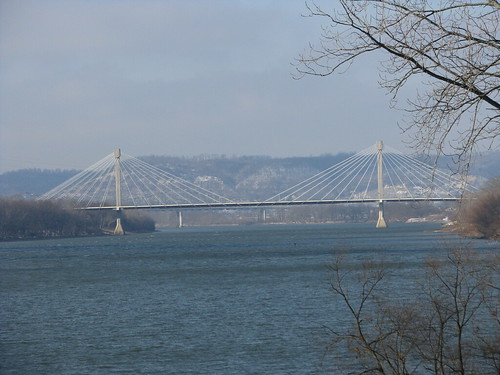
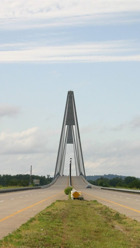
Natcher Bridge – near Owensboro, Ky.

The Natcher Bridge is enormous. Driving east out of Owensboro, the bridge looms before you even miles before you get close to it. It’s modern style is what I really think sets it apart. At the time of its construction, it was the longest cable stayed bridge over an inland waterway in the United States (4,505 feet long including approaches, yet only 67 feet wide). Opened in 2002, it was built to relieve traffic over the Glover Cary Bridge in downtown Owensboro several miles down river. The ultimate goal is for the bridge to be a part of a four lane highway system connecting Interstate 64 in southern Indiana and Interstate 65 at Bowling Green. The connector would utilize the existing Natcher Parkway would allow travelers to bypass Louisville.

Study for the project began in 1983. U.S. Rep. William Natcher and Senator Wendell Ford sought funding for the bridge. In 1988, Natcher secured the millions of dollars required for preliminary work, design and right-of-way acquisition. As with many projects of this size, there were significant construction delays and delays in federal funding. The bridge finally opened to traffic in 2002.

About Rep. Natcher: He represented Kentucky as a Democrat in Congress for 41 years. Natcher was a champion of the freeway system. He holds the record for most consecutive votes in Congress. When he was sick, a vote was delayed so that he could attend. He died in 1994, before construction of the bridge had begun, but even the proposed bridge bore his name before his death.

NoD: Union Mill Bridge Down for the Count

Union Mill, Kentucky
An Overgrown Union Mill Bridge;
Photo by George W. Dean
Site of the old Union Mill Bridge;

December 2011

In 1915, raging flood waters took from the Jessamine County community of Union Mill its covered bridge. The bridge connected the two sides of this community and provided a link between Nicholasville and the Valley View Ferry. Almost immediately, the Jessamine Fiscal Court awarded the contract for construction of a replacement bridge to Lexington’s Empire Bridge Company. The new bridge was to be of steel truss at a price was $2,697.

Spring 2010;
Photo by George W. Dean

About forty years later, the 1915 bridge was abandoned when the road was rerouted slightly downstream. For over fifty years, the abandoned bridge experienced rising and receding waters as well as an annual vegetation that nearly hid the bridge itself. But the years took its toll. Photos by Magistrate George W. Dean reveals only 2 1/2 feet of bridge above the water leaving an entire “roadbed” submerged for several days during the floods in the spring of 2010 (see photo at left).

Following the 2010 spring floods, local authorities discussed what could be done to restore and preserve this nearly century-old Jessamine County landmark. Any repair, however, would only prove to be a short-term fix. So costs and the lack of potential reuse left leadership with tied hands. With a new bridge over Little Hickman Creek just yards downstream, safety could not be ignored.

As a result, the last weekend in November 2011, witnessed the removal of that old truss bridge which had spanned the Little Hickman Creek for nearly a century.

Sources: George W. Dean emails; Jonathan Parrish emails; Municipal Journal

EV: The Big Four Bridge

The Big Four Bridge from Waterfront Park – Louisville, Ky.

The Big Four Bridge was for a long time an old abandoned rail bridge on the east end of downtown Louisville. The Big Four gets its name from the Big Four railroad – the nickname for the now defunct Cleveland, Cincinnati, Chicago and St. Louis Railroad. For years, the bridge sat in the middle of the river, with both the Indiana and Kentucky approaches having been removed in 1969 and sold for scrap after the railroad fell into disuse.

Construction began on the bridge in 1888. During the construction, an astounding 37 people died. Two accidents with pier caissons caused drownings, and a horrible accident occurred when the collapse of construction equipment killed 21 workers. The bridge was completed in 1895.

In recent years, there has been a move to convert the bridge into a pedestrian and bicycle bridge. This conversion has been in the works for years and has proceeded at a snail’s pace. What you see above is the completed entrance ramp on the Kentucky side, though no similar entrance exists on the Indiana side. The entrance was closed when I visited, but looked quite impressive from the ground.

(PJWB side-note): In the 1960s, architect Jasper Ward proposed a housing development on the Big Four. The Louisvillian-Manhattanite at Broken Sidewalk has closely followed the developments at the Big Four Bridge.

NoD: Pikeville’s Pauley Bridge

Pauley Bridge - Pikeville, Ky.
Pauley Bridge – Pikeville, Ky.

Walking across the wooden bridge, restored to its original 1930s beauty, evokes thoughts of simpler times. The bridge slightly sways, but the strong stone towers comfort those who cross. Beneath my feet, I spy flora growing and water flowing in the gaps on the bridge’s bed.

Spanning the Levisa Fork of the Big Sandy River just to the north of Pikeville is the Pauley Bridge. Named for the local community that was annexed by Pikeville in 1990, this suspension bridge has stood since 1936. When it was listed on the National Register in 1992, the Pauley Bridge was still open to vehicular traffic and was one of only four swinging suspension bridges open to vehicular traffic in eastern Kentucky (many others were open to pedestrians only, as Pauley Bridge is today).

Strong cables connect the towers to the banks on either side of the river, while vertical tension hangers connect the main cables to the bridge deck. This swinging suspension bridge design is one of the simplest, and most inexpensive, bridge designs which is why they have been such a popular design. In larger suspension bridges like the Roebling Bridge in Newport, a stiffening truss under the bridge deck strengthens and stabilizes the structure.

The design of this bridge is unique, however, because although the bridge itself is simple – the towers are not. The beautiful rough-cut sandstone towers are impressive. Of the 37 wire suspension bridges proposed by the WPA for construction in southeast Kentucky in the late 1930s, only the design of the Pauley Bridge included these sandstone towers.

Pauley Bridge - Pikeville, Ky.A WPA project begun in 1936, the bridge was completed and opened to traffic in 1940. In 2000, it was closed to vehicular traffic (2001, all traffic) and it quickly acquired the appearance of  an abandoned site. But in 2004, the City of Pikeville set aside funds to restore the historic bridge. In 2006, it was reopened as a pedestrian and bicycle bridge.

Above the keystones on either tower are engravings bearing the mark of the 1930s construction project: “WPA” and the year construction began “1936.” Thanks to the City of Pikeville, the Pauley Bridge has a new lease on life. More pictures of the Pauley Bridge can be viewed on flickr.

NoD: Camp Nelson Bridge (v. 2.0)

Camp Nelson
Abandoned Camp Nelson Bridge – Jessamine/Garrard Counties, Ky.

Three bridges have crossed the Kentucky River at Camp Nelson and the pictured bridge was the second installation having replaced a double-barreled covered bridge that  had carried travelers since 1838. Today, this abandoned bridge has been replaced by the less-scenic bridge that has carried four lanes of  US-27 traffic since 1971.

This steel truss bridge features two Pennsylvania-style trusses which span 275 feet over the Kentucky River; with abutments and approaches, the length is extended to 543 feet. When the waters of the Kentucky River are lowest, the bridge rises 60 feet above them. Over 600,000 pounds of structural steel were used for construction, including the 15,000 rivets connecting the I-beams. [*] Bridges are impressive structures and version 2.0 of the Camp Nelson trilogy doesn’t disappoint.

As with all things abandoned, it is a little eerie to walk onto the bridge — completely alone. The rusting trusses and fauna growing through cracks and clumps of dirt give a certain “Life After People” aura. But the spectacular views from this bridge, and the perspective of the three different Camp Nelson bridges is in itself a walk through history.

NoD: Simon Kenton Bridge

Maysville, KY
Simon Kenton Bridge; Maysville, Ky.

The Simon Kenton Bridge spans the Ohio River between Maysville, Ky. and Aberdeen, Ohio (the picture above was actually taken in Aberdeen). The bridge opened on Thanksgiving Eve, 1931. Until that time, ferries were used (photo) to transport people across the Ohio (vehicular traffic had to go through either Newport, Ky. to the west or Portsmouth, Ohio to the east).

The first ferry authorized in Maysville (f/k/a Limestone) was in 1794 to Benjamin Sutton for whom Maysville’s Sutton Street is named after. But with the completion of the Simon Kenton Bridge, the ferries came to an end.

You may recall that Limestone was once part of Bourbon County and leaders from this region, including the namesake of this bridge (Simon Kenton), traveled to Paris to conduct county business. In 1777, Kenton saved the life of Daniel Boone and Kenton County is named after him. Born in Virginia and making his mark in Kentucky, Kenton ultimately settled and died in Ohio.

When this silver-painted suspension bridge opened, 15,000 people turned out. Four high school bands and the University of Kentucky Marching Band all performed to celebrate the opening of the 3,163 foot bridge. [*] Designed by a Harrisburg, Penn. firm, the superstructure was completed by the famous J.A. Roebling Company which had years before designed the Roebling Bridge in Covington (as a design model for its more famous Brooklyn Bridge). In 1945, the tolls were removed and the bridge became toll-free.

NoD: Bridges of Camp Nelson

Camp Nelson
Camp Nelson Bridge, Jessamine/Garrard county line, Ky.

Pictured above are the three bridges, or at least what remains of them, which crossed the Kentucky River from Jessamine into Garrard County. In the upper-left you can see the current Camp Nelson Bridge which carries US-27 high above the river. In the middle remains the southern stone approach from the double-barreled covered bridge that spanned the site for nearly 100 years (1838-1933). The steel-truss structure from which this picture was taken remains, but is closed to traffic; it was open from 1933 until 1971.

More on each of these three bridges to come…

NoD: Limestone (n/k/a Maysville)

Maysville, KY
Waymarking Sign, Maysville, Ky.

Lexington’s Limestone Street travels north to merge with Paris Pike and its history is there forgotten. Ultimately, you can take the road all the way to the Ohio River at Maysville. And Limestone Street was once aptly named since Maysville was formerly known as Limestone. Limestone was first settled in 1784, the road to Lexington (an old buffalo trace) was almost immediately established. [*]

In 1787, Limestone was formally established by the Virginia General Assembly which changed the name of the community situated at the confluence of Limestone Creek and the Ohio River to Maysville. At the time, Limestone/Maysville was part of Bourbon County (and was until Mason County was created in 1789) and was a key riverport for the bourbon whiskey industry.

By 1833, Maysville was a thriving riverport and was made the county seat of Mason County in 1848 (it was a contentious vote, as Washington was previously the county seat). The name “Limestone” was used to identify the community until the mid-nineteenth century as well.

NoD: U.S. Grant Bridge

U.S. Grant Bridge
U.S. Grant Bridge spans the Ohio River; Greenup County, Ky.

A spectacular bridge spans the Ohio River at South Portsmouth, Kentucky (and Portsmouth, Ohio) and carries U.S. 23 traffic to and from Kentucky. The current bridge opened to traffic on October 16, 2006, after five years of construction. The original U.S. Grant Bridge was built in 1927 and was demolished in 2001.

Named after General (and later the eighteenth President) Ulysses S. Grant, the bridge is a cable-stayed bridge that cost over $38 million to construct. The two-lane bridge is 2,155 feet in length. [*] Check out these other pictures of the US Grant Bridge!

No Destination: Catlettsburg

Catlettsburg, Ky.
Catlettsburg, Ky.

The population of Catlettsburg is only two-thirds of its size as of the 1900 census. As the county seat of Boyd County… wait? I thought Ashland was the county seat of Boyd County. It’s not? No. It is actually Catlettsburg.

Confusion aside, the location of Catlettsburg is strategic being located at the confluence of the Big Sandy and Ohio Rivers. It was a home of the U.S. District Court for the Eastern District of Kentucky from 1911 until 1985. The population also declined to “urban sprawl,” which is not a concept you would think of when you think of a hamlet of 1,800 (within the city limits, but Catlettsburg’s ZIP code has a population of about 10,000). But in the 1960s and 1970s, the realignment and expansion of US 23/60 through the area prompted the removal of many residential units which were never replaced.

Catlettsburg was a major timber market in the late 19th century and as a result there are very few trees. I selected the picture above because it was one of the few tree-lined streets I noticed in the central area. It also featured homes (though many were converted to commercial use) which were, as noted above, an anomaly. For more of my Catlettsburg pictures, check out Flickr.