No Destination: Shelbyville

5th & Main, Shelbyville, KY with county courthouse in background

In 1792, Kentucky became a Commonwealth, Shelby County split from Jefferson County and Shelbyville was first settled (though it would not be incorporated until 1846). Both the county and the city are named after Kentucky’s first governor, Isaac Shelby.

Civil unrest came to Shelbyville even before the Civil War began, prompting local officials to erect a blockhouse in the center of town. It stood at the intersection of what is now Fifth St. and Main St. and remained until “civil law and order were assured” in 1870. The intersection remains – with the courthouse, city fountain and memorial park – Shelbyville’s civil center (which is odd, given that it is Fifth Street).

Downtown Shelbyville is built around two one-way streets (Main and Washington) running parralel to one another. Historic sites, antique shops, cafes and other businesses prosper.

No Destination: Union Mill

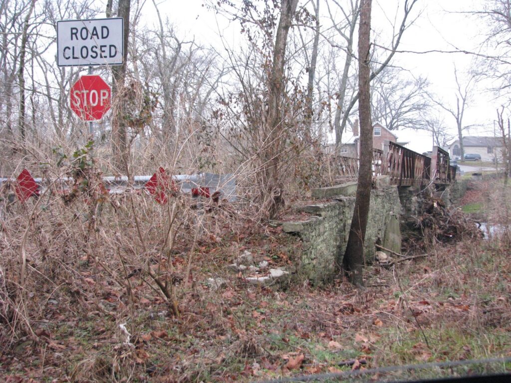
Abandoned Bridge, Union Mill (Jessamine Co.), Ky.

The Jessamine County community of Union Mill (on KY-169) once was home to a successful distillery operation, one of several that used to operate in the county. The beautiful Hickman Creek (pictured below at right) provided the necessary moving water for both the distillery and the gristmill.

The first gristmill was constructed and operated by Joseph Crockett, a Revolutionary War veteran, around 1800. By the middle of the 1800s, the distillery was operating and bottling “Old Lexington Club Whiskey.” The mills produced “Hickman Lily” and “Snow on the Mountain” flour. But Prohibition shuttered the distillery, and the mill and community followed. [cite, PDF]

An old 150-foot covered bridge once traversed the creek. According to some reports the covered bridge was replaced in 1915 (see comments to this post), while other reports indicate it was lost in to flood waters in 1932. Still visible below the abandoned four-span, steel bedstead and pony truss bridge that followed is the original stonework from the covered bridge. [Kentucky’s Covered Bridges (KY) (Images of America)]. All of this was abandoned when, in 1955, KY-169 was rerouted slightly to the west.

UPDATE: Immediately below is a picture sent to me by the author of Kentucky’s Covered Bridges, Walter Laughlin, which shows the old covered bridge in its heyday.

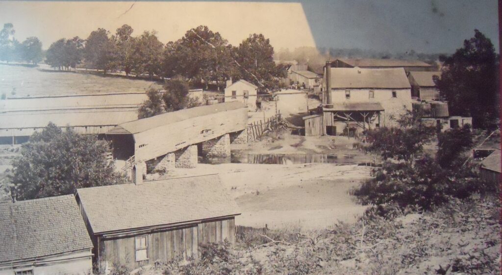
Union Mills Covered Bridge
Photo Courtesy of Walter Laughlin


ANOTHER UPDATE: I’ve seen it before, but never added it. From the old Sanborn insurance maps comes this gem, circa. 1903. It identifies the pictured covered bridge and the different buildings related to the distillery. The distillery was in operation daily, five months out of the year. Yield was 20 barrels. See photo below:

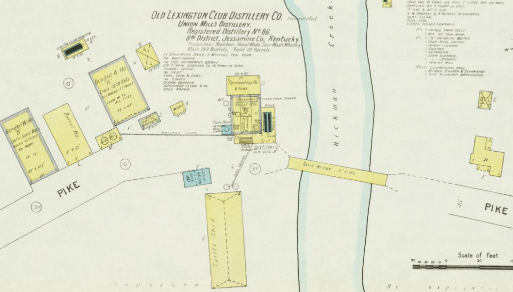
Sanborn Insurance Map, ca. 1903 of Union Mill (Source)

Additionally, check out my post from December 2010 wherein I reported on the ultimate demise of the steel pony-truss bridge.

No Destination: Lebanon

Three miles from the middle of Lebanon is the geographic center of Kentucky, but this community of about 6,000 stands on its own. First settled in the 1700s, the town was incorporated in 1815. Named after the “Biblical Lebanon” because a number of cedar trees also grew in this area. Much of the communities growth can be attributed to the L&N Railroad that once rolled through town. The historic depot constructed in 1857 survived a burning by Gen. Morgan’s men during the Civil War, but it could not escape teenage arsonists in 1992.

The above-picture is clearly not the best, but it shows the route that the railroad once took a block north of Main Street. In the distance you can see the Marion County municipal building. A new courthouse is being built just to the south of this municipal building. Hopefully, the historic courthouse on Main Street will be preserved!

Bonus Kaintuckeean: J. Proctor Knott. A Kentucky Congressman, Governor and member of the 1891 Constitutional Convention during which he led the effort to keep Frankfort as Kentucky’s capital. He was also the first dean of Centre College’s law school. Knott County is named after him. [Marker 728]

No Destination: Campbellsville

Centrally located Campbellsville – Taylor County’s seat – is eighty miles from Lexington, Louisville and Bowling Green. Established in 1817, the town’s history is quintissentially Kentucky. Began as a grist mill, grew in population as a stop on a stagecoach route and later a rail line, and the target of Civil War raids by the infamous Gen. John Hunt Morgan. Today, Campbellsville’s Main Street (pictured, above) remains active with a number of businesses due at least in part to the presence of Cumberland University.

What is now Campbellsville was on the Cumberland Trace – that route through the Cumberland Gap that would serve as the early route for western settlers; ultimately those who passed through what would become Taylor County continued past the Cumberland River to what is now Nashville, Tenn.

Taylor County was separated from Green County in 1848 (named for General Zachary Taylor in the same year that he would become President) and Campbellsville at that time was selected to be the seat of the new county. The first courthouse was erected soon thereafter and was destroyed during an 1864 raid by Confederate forces. The next courthouse was built and survived until 1965 when it was razed in favor of a “contemporary” brick design. This is another instance in which, architecturally speaking, the courthouse project currently underway in Kentucky is “a good thing” as the new Taylor County Courthouse has that “modern take at an old building” quality that at least returns a bell tower to the courthouse square. All historic markers, however, remain at the site of the 1965 courthouse.

Nate, on his courthouse visits, loves the feel of coming over the hill into a town to see the tallest building in town – his immediate indicator of the courthouse’s prominence and central role for a community. Not in Campbellsville: the tallest spire will lead you up a hill to the Campbellsville Baptist Church (pictured, right). The congregation began as early as 1791, but the name of the church was not adopted until 1852. Following a 1962 fire, the present church was constructed. It replaced a 1916 sanctuary that consisted of “a domed ceiling and four walls of stained glass.”

No Destination: Columbia

The county seat of Adair County is full of history, and it is clear that the community is dedicated to the preservation of the same. On the courthouse “lawn” (watch out Nate; when you get to Columbia, the Courthouse is situated in the middle of the town square with nary a place to walk on) there lie several historical markers. The old courthouse remains the focal point of downtown with a preservation effort underway to deconstruct the additions erected in 1976 (presumably, this will recreate a courthouse lawn). As in so many Kentucky counties, a new judicial center has been erected taking some business out of downtown Columbia.

Even so, the downtown public square bustles with shops. The Columbia Bank has operated since 1866; cafes and shops remain active. The only sign of decay is the old Columbian Theater, whose empty marquis reminds us of the loss of small theaters at the expense of the multi-plex.

Columbia is the home of Lindsey Wilson College, a liberal arts college. The town hosts its annual festival, Downtown Days, each summer with nearly all of the town’s 4,000 inhabitants (2000 Census) coming to celebrate.

The town, first settled in 1800, was laid out as the county seat in 1802. It was the childhood home of Jane Lampton, the wife of John Marshall Clemens and the mother of “Mark Twain.” The Courthouse has many interesting features, but I will (as usual) leave those for future posts as part of the Kentucky120 Project.

No Destination: Glens Fork

This was one of my…wait a minute, turn around, stop look again, and take a picture moments. Occasionally, you see something seemingly out of place and different. This is the Glens Fork, Kentucky Post Office.

First, it is a old post office. I wasn’t sure if it was still an active post office (according to USPS.gov it is not), but I found it intriguing. After all, Glens Fork has its own Zip Code, “42741..” It turns out that the building dates to 1932 and that the post office was reactivated in 1986 before its service was later discontinued again.

There is a lot of history to this unincorporated community in Adair County. A three-part history of Glens Fork (aka Glensfork, Glenville and Hardscratch) is interesting and informative. [Welcome Hamon, History of Glensfork, Kentucky, (Michael Watson, ed., Adair County Review, 1992-1993), available via Columbia Magazine]. The town was established by an act of the General Assembly in 1872 and it attempted to lure a Baptist College to town in 1874: “Glenville offers a thousand dollars to the proposed Baptist College, if it is located there.” (Farmer’s Journal, Nov. 11, 1874). The Baptists decided not to locate in Glens Fork, instead choosing Campbellsville for the site of its Russell Creek Academy (nka Campbellsville College).


At some point, the town’s government dissolved and this community turned into a mere crossroads at the junction of KY-55 and KY-768.

No Destination: Jamestown

Although Russell Springs is the largest city in Russell County, Jamestown is the county seat. Originally named Jacksonville (after President Andrew Jackson), the area was renamed to honor James Wooldridge who had given the land for the town. The renaming of the community was actually prompted for political reasons; those opposed to Jackson came into power in the area around 1826.

Two Civil War skirmishes occurred near this sleepy community, a community that grew in popularity (particularly in the summer months) after the U.S. Army Corps of Engineers completed Lake Cumberland in 1952. [Simultaneously, the population of Russell County dropped 19.3% between the 1950 and 1960 census.]

Jamestown’s city center is well-designed. A large town square finds the old (1978) courthouse in one corner, which is complemented on its opposite corner by the new judicial center (under construction). The other two corners have a number of businesses, including cafes, antique stores and other small-town essentials. The northwest corner is pictured above. In the center of the square is a large American flag under which a Doughboy stands as a memorial to the soldiers who served our nation. All of which begs the question: How many Doughboys stand on the “lawns” of Kentucky courthouses? (Casey and Carter Counties, among others, come to mind…)

No Destination: Russell Springs


This community – Russell County’s largest – was known as Big Boiling Springs when it was founded, though the local post office (est. 1855) postmarked letters as being from Kimble, Ky. It was not until 1901 that the town was named Russell Springs.

I drove through quickly; the only site I was able to see was a historic marker in a small park – Chalybeate Springs:

A health resort long known as Big Boiling Springs, operated before 1850 by family of Sam Patterson, among the earliest settlers. Log cabins (12) called Long Row were built for guests who came here for amusement, pleasure, and the medicinal iron and sulphur water. In 1898, large hotel built which burned in 1942. The spring has been capped for use as a well. [Marker 1233]

Unfamiliar with the term ‘Chalybeate’ I inquired further. The term simply refers to mineral spring waters with heavy iron deposits. Derived from the latin word for steel, “chalybs,” the most famous chalybeate spring is Turnbridge Wells in Kent, England. Lord Dudley North discovered Turnbridge in 1606 and later wrote: “These waters youth in age renew //Strength to the weak and sickly add //Give the pale cheek a rosy hue //And cheerful spirits to the sad.” [cite].

NoDestination: Somerset


Somerset, the seat of Pulaski County, is apparently a haven for tourists making the trek to Lake Cumberland during the summer months. During the winter months, however, this community is quite sleepy. First settled in 1798 and named after Somerset County, New Jersey, Somerset was incorporated in 1887.

Pulaski County, Kentucky’s 27th, was named after Polish County Casimir Pulaski who came to America to help and fight for our independence (among other things, he at one point saved the life of George Washington). Pulaski gave his own life for the cause of American freedom at the Battle of Savannah; he died October 11, 1779. In fact, KRS 2.140 requires each October 11th to be commemorated in Kentucky as “General Pulaski’s Day.”

Unfortunately, you would not learn much of this in Somerset. Despite a few memorials, history is not at the forefront of this community’s concern. It’s most impressive monument was erected in 1976 to commemorate the nation’s bicentennial; it is located in a parking lot between two strip malls/office parks. Pictured above, it is a white brick obelisk with an eagle perched on top. In front, is an exposed portion of the spring which first brought settlers to this location. The saying goes (and is inscribed in the memorial), “Whoever drinks from Old Town Springs has Wisdom & Will Always Return to Somerset.” Witnessing the spring (as pictured below) makes me leery of drinking this water, despite any promise of Wisdom.

NoDestination: Spears


Spears, Kentucky is one of those county-straddlers. Because the center of Tates Creek Road was used as the boundary between Jessamine and Fayette counties upon the creation of the former, this community on Tates Creek Road (KY-1974 at the junction with KY-169) is also in both counties. It was settled in the early 1790s by John L. Spears; other settlors followed as Spears was a well-educated man known for being both a surveyor and a teacher. (Today, Spears is serviced by two county school systems – depending on which side of the street you are on.) Spears even had its own post office from 1867 until 1915.

Pictured above is the Fayette County Old Country Store; across the street is another market in Jessamine County.