NoD: Georgetown Community Airport’s AirFest

AirFest 2011 at the Georgetown-Scott County Regional Airport - Kentucky
Kentucky Air National Guard C-130 – Georgetown, Ky.

The history of Georgetown’s community airport began in 1987 when the airport board had only $500 dollars. Seven years later, a 4,000 foot runway opened with a single hangar and no income. When last year’s World Equestrian Games was on the horizon, the Georgetown-Scott County Regional Airport underwent a $4 million renovation which involved the construction of a beautiful terminal, expanded hanger options and a longer runway.

AirFest 2011 at the Georgetown-Scott County Regional Airport - Kentucky
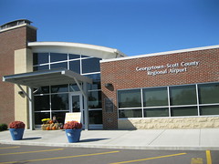
Terminal at Georgetown-Scott Co. Regional
Airport – Georgetown, Ky.

Not long ago, the airport board broad even more attention to this community airport with a well-executed airshow called AirFest which both I and the lil’ Kaintuckeean attended.

Although his favorite plane was a two-seat experimental that looked quite similar to Anakin’s craft on Star Wars, we both were also quite impressed with the C-130 Hercules transport brought in by the Kentucky Air National Guard. This behemoth plane is impressive.

Although only there for a little over an hour, we witnessed several takeoffs and landings of experimental, military and historic aircraft.

The Georgetown-Scott County Regional Airport is a great facility located just east of Georgetown on US 460. I hope to return next year for another AirFest (if it becomes an annual event)! You can view more pictures of the Airport (and from Airfest) on flickr.

NoD: Oregon is a place inside Kentucky. Huh?

Oregon, Kentucky
Landing at Oregon, Kentucky

When you think of Oregon, you probably conjure up an image of a western state with beautiful panoramas of the Pacific Ocean and the towering Cascade Mountains through which the Columbia River cut its own gorge.

Well, I’ve got a different image that I recognize on hearing the word. A winding, descending country road headed toward the river with animals – wild turkey among them – not afraid to explore this road less travelled. At its end, a river as quiet as the boat landing it passes. It is here I pause to savor the silence, the quiet, the peace.

The place: Oregon, Kentucky, a small community on the Kentucky River about five miles from Harrodsburg. It is unknown how the community, originally named Harrods Landing after James Harrod who settled the nearby county seat in 1784, received its current name. What is known is that it assumed its present name by the mid-1800s and it was an important Kentucky River port. Over the years, the community has also been known as Warwick. A roadside historic marker (#1751) reads:

Warwick flourished for some 50 years and was succeeded by Oregon. Both were early shipping ports. Flatboats, during Warwick era, and later steamboats, at Oregon, ran regularly between here and New Orleans. This point was at head of slackwater navigation on Kentucky River. The creek is still called Landing Run because of significance to James Harrod.

Among Oregon’s most notable residents was Clay Lancaster, an authority on American and Kentucky architecture and a leading proponent of historic preservation. He acquired in 1973 the Moses Jones House, an early federal residence in the area, and called it his home until his death. The property is now maintained by the Warwick Foundation.

My connection to Oregon dates to May 6, 2009. Having just completed my final exam in law school, I set out to clear my mind. So I began driving and a saw a few wonderful sites in our beautiful Commonwealth, among them this winding road toward the Kentucky River that took me to Oregon. I sat in my chair, pictured above, and experienced a calmness. Yes, law school was over. And it was here that I found the  basis for #NoDestination and this blog.

NoD: Old Family Graveyard Not So Rural Anymore

Cemetery - Nicholasville, Ky.
Aaron Farra Family Graveyard – Nicholasville, Ky.

As Kentucky’s landscape changes, old farmhouses and barns are often torn down. The same goes for churches, post offices and general stores. Entire communities are consumed by an ever-growing suburbia.  But what of the cemeteries?

In Kentucky, state law charges cities and towns with preserving burial grounds within the city limits. A perfect example is in Nicholasville where local ordinances about a decade old mandate specific treatment in cases of cemeteries within areas of development. In February 2003, the Aaron Farra Family Graveyard was removed from its original location.

With the aid of developers and the Jessamine County Historical Society (JHS), great detail was taken in exhuming all of the bodies and caskets. The arrangement of bodies and headstones was carefully documented so that the new cemetery location would mirror the original internment site. Today, the cemetery is immediately adjacent to Kohl’s Drive off U.S. 27, but it was originally 921 feet southwest of its current location. If it had been left alone, the Farra Family Graveyard would be underneath Sam’s Club! (There’s also a Starbucks within eyeshot of the cemetery.)

Aaron Farra and his wife, Sally Neet Farra, once owned this land. Aaron and Sally passed this world in 1859 and 1861, respectively, an 1861 map of property owners in Jessamine County identifies a large area of land – on both sides of the Nicholasville Turnpike as it was once called – controlled by different members of the Farra family. Yet, it seems little is known of the family.

Sally’s parents, George Neet (born in Germany in 1767, his headstone is pictured above with the Kohl’s Department Store in the background) and Sally Neet, are buried here. As are a few of Aaron and Sally’s grandchildren. The earliest burial in this family graveyard was in 1826 and the most recent in 1866.

The graveyard is surrounded by an iron fence which was also transplanted from the original site. It is a well-maintained, small cemetery in what many now find an ‘odd’ location. But remember, they were here first!

Cemetery - Nicholasville, Ky. Cemetery - Nicholasville, Ky. Cemetery - Nicholasville, Ky. Cemetery - Nicholasville, Ky.

more photos are available on flickr

Sources: 1861 mapJHS Cemetery Listing; JHS Newsletter; Rootsweb

NoD: Boy Scouts Began in Pulaski County

Boy Scouts Historic Marker - Burnside, Ky.
Historic Marker – Burnside, Ky.

Two years before the Boy Scouts of America organized in the United States, Mrs. Myra Greeno Bass gathered a troop of 15 Pulaski County boys in 1908. Utilizing British scout literature, she guided the boys in hiking and camping. A Kentucky roadside historic marker (#1007) on U.S. 27 in Burnside reminds travelers of this great contribution:

Before Boy Scouts of America was organized, 1910, a troop of 15 had been formed here, spring of 1908, by Mrs. Myra Greeno Bass. Using the official handbook of English scouting, she guided them hiking and camping, like scouting today. Known as Eagle Troop, Horace Smith was troop leader. Insignia was a red bandanna around neck. Reputed the first American Boy Scout Troop.

Of course, several other communities around the country declare themselves the home of the boy scouts. We Kaintuckeeans will hold to Burnside as being the groups American place of origin. Today, the Boy Scouts of America is headquartered in Texas and boasts nearly 115,000 troops consisting of over 2.7 million youth members. Well done, Mrs. Bass!

NoD: Grayson Lake and the Kitchen-Horton House

Grayson Lake - Grayson, Ky.
Grayson Lake – Carter County, Ky.

Named for the Carter County seat, Grayson Lake was formed by the Army Corps of Engineers in 1964 from their formation of an earth and rock dam on the Little Sandy River. Now, almost 75 miles of shoreline in Carter and Elliott counties surround this beautiful lake of approximately 1,500 acres.

Filled with bluegill, bass, catfish, crappie, and trout, the lake is very popular with local anglers. But history has its tale at Grayson Lake as well. Whenever I visit an Army Corps manmade lake, I’m reminded of the scenes from O Brother, Where Art Thou?
when the valley is flooded saving George Clooney et al. from the gallows  (Youtube) as well as the following scene where he opines on the New South being hooked up to the grid (Youtube). Surely, much in the flooded valley of Grayson Lake was lost when the waters rose in the mid 1960s.

Grayson Lake - Grayson, Ky.One structure, however, was moved from its foundation on the north bank of the Little Sandy River and now rests 700 feet northeasterly in a recreational area adjacent to the lake. The historic Van Kitchen Home (pictured at left) was built around 1835 by Elijah Horton. This log cabin was built in the “saddlebag” design, meaning two cabins close enough to one another that they share a common chimney. Although once prevalent through eastern Kentucky and West Virginia, the design has become quite rare.

After reaching Grayson during his “masterful retreat” from the Cumberland Gap, Gen. George Morgan (USA) continued toward Camp Dennison, Ohio with the Thunderbolt of the Confederacy – John Hunt Morgan – nipping at his heels. Gen. George Morgan supped at the Horton house and his men camped nearby, but their stay was disrupted by Gen. JHM’s men and a skirmish ensued. Bullet holes are still visible in the walls of the ol’ saddlebag’s second floor. The Van Kitchen House, named after the last family owning the house prior to the government’s acquisition in 1965, was listed on the National Register in 1974.


Grayson Lake - Grayson, Ky. Kitchen-Horton House @ Grayson Lake - Grayson, Ky. Grayson Lake - Grayson, Ky. Grayson Lake - Grayson, Ky.
additional photos on flickr

NoD: Salyersville Bank

Salyersville, Ky.
Salyersville Bank Building – Salyersville, Ky.

One building in downtown Salyersville stands out: the Salyersville Bank at the corner of Church (KY 7) and Maple (US 460). An impressive two-story limestone structure in the Beaux Arts style constructed by Italian craftsmen who arrived in eastern Kentucky during a coal boom in the early twentieth century. Built in 1912, the Salyersville Bank anchored Salyersville’s growth.

A short-lived oil boom beginning in 1918 marked the county’s oil fields as producing the third highest volume in the state by 1922. The bank was instrumental in securing the funds the enterprise required. A 1927 flood caused great damage to Salyersville’s commercial district, but the bank remained open and able to help local merchants get back on their feet.

When the Great Depression hit, the Salyersville Bank continued to operate in part to its sound financial practices. The dirt roads of downtown Salyersville were certainly affected by the Depression, but this institution helped to convert the town’s center in 1936 from wood to brick. Many of the yellow brick buildings on Church Street across from the courthouse bear the 1936 construction date.

The Salyersville National Bank, chartered in 1902, no longer operates out of this location, but the institution remains in business elsewhere in the county.  Although Salyersville and Magoffin County have fallen on hard times in the past few decades, the Salyersville Bank building remains as a testament to the community’s prosperity a century ago.

Source: Nat’l Register

NoD: McCreary County from Mile Marker 0

KY-TN State Line @ US27
US 27 at the Tennessee State Line – McCreary County, Ky.

On a recent trip to Tennessee, I found myself eschewing the interstate in favor of Highway 27. From the Tennessee border, one crosses through McCreary, Pulaski, Lincoln, Garrard and Jessamine counties and the trip marked my first venture into McCreary County.

When not travelling by interstate, a state line can be a fascinating place. A noticeable line in the asphalt marks where one transportation’s work ends and another begins. ‘Unbridled’ signage encourages entrance to Kentucky while the “McCreary County” and “Mile 0” signs are mere statements of fact. But the broader picture is grand. At the state line, Kentucky’s state flower – goldenrod – grows. A cigarette store in Kentucky sits only feet from Tennessee, but offers our neighbors to the south a great discount on tobacco due to our lower taxes on the product. But Rocky Top isn’t short changed as they host a liquor store a mere 15 yards from dry McCreary County.

McCreary County is quite unique in that its county seat, Whitley City, is not an incorporated city. In fact, McCreary County has no incorporated cities or towns — the only county in Kentucky with such a claim. McCreary County was the last Kentucky county – #120 – when it was formed in 1912 from Pulaski, Wayne and Whitley counties.

During the Civil War, the area was very pro-Union. Even so, the county is named after a Confederate war hero and two-term Kentucky governor, James B. McCreary. It is a beautiful county that creates another beautiful entrance into the Commonwealth.

KY-TN State Line @ US27 KY-TN State Line @ US27 KY-TN State Line @ US27 KY-TN State Line @ US27

Pictures by the Kaintuckeean on flickr.

NoD: Rural Carriage House

Carriage House - Madison County, Ky.
Carriage House – Madison County, Ky.

When driving through Madison County earlier this year, I was struck by the number of “destinations” along U.S. 25 south of Richmond. Historic markers abound, a military complex is imposing, and this abandoned carriage house stands as a reminder of days gone.

I’ve previously written a series on the carriage houses of Lexington’s Gratz Park (series pts. 1, 2, and 3), but unlike those urban instances this carriage house appears in a rural setting. Although I cannot find any specifics on this carriage house at this time, I am hopeful that readers might fill in the gaps.

The carriage house is situated off a small private road adjacent to US25 (Berea Road), formerly the eastern portion of the Dixie Highway. It is probable that the private road was the original Dixie Highway and that the carriage house opened directly upon it. With two stories and large windows above each of the carriage ports, it is likely that living quarters were included above. The stately stone entrance to the drive reveals no great manor behind, likely the home to which the carriage house belonged has been lost to the annals of history. (Any help on the history here… por favor?)

Amazingly, the only reference to this carriage house I can find online comes from the Madison County Quilt Trail as the Star Shadows barn quilt can be seen behind the carriage house.

Oh… and check this out: I’ve added Lightbox to the blog.

 Carriage House - Madison County, Ky. Carriage House - Madison County, Ky. Carriage House - Madison County, Ky. Carriage House - Madison County, Ky.


Photos on flickr.

NoD: Pikeville College began in today’s City Hall

Pikeville, Ky.
City Hall – Pikeville, Ky.

In 1887, three men rode into the hills of eastern Kentucky as members of the Ebenezer Presbytery, now part of the Presbyterian Church, USA. These men – Dr. W.C. Condit of Ashland, Dr. Samuel B. Alderson of Maysville, and Dr. James Hendricks of Flemingsburg – were concerned that “some of America’s finest people were being neglected both in educational and spiritual development.” After several trips into the area and upon the urging of the people, it was determined that Pikeville (then a community of about 300 people) should be the situs for an educational facility.

Pikeville, Ky.Ground was broken in 1889 for the Pikeville Collegiate Institute and the Institute held its first classes on September 16, 1889. Using clay from the nearby Big Sandy River, bricks were fired on-site to create this two story structure which rests upon a foundation of locally sourced stone. The building is the oldest educational building in Pike County, even though its purpose is no longer educational. The building is also considered to be one of the oldest within Pikeville’s city limits.

Pikeville Collegiate Institute, in 1909-1910, split into Pikeville College and the Pikeville College Academy, a prepatory institution. The Academy occupied this building, dubed the “Old Academy Building,” until the Academy closed in 1955. When the building was added to the National Register of Historic Places in 1973, it was used for art classes but had been used over the years for classes, as a community center and as a chapel. After a period of abandonment, the City of Pikeville restored the Old Academy Building as its City Hall.

Bibliography
Cornelius Carroll
Historic Marker
National Register

NoD: “The Man Who Moved A Mountain”

Pikeville, Ky.
William Hambley, “The Man Who Moved a Mountain” – Pikeville, Ky.

From 1973 until 1987, over eighteen million cubic yards of earth was moved in a project known as the Pikeville Cut-Through. It was the largest earth moving project ever undertaken in the United States and only the second largest in the western hemisphere, paling only to the Panama Canal project.

But this isn’t about the project, it is about the man behind the project. A man who loved Pikeville, but who didn’t like how dusty she was. So he decided to take action.

Even in elementary school, William Hambley didn’t care for the railroad tracks that divided his hometown and the local college. The tracks also created a “wrong side of the track” mentality and the substandard housing that comes with it.

The railroad tracks also brought dirty coal cars through the middle of Pikeville. Intermittent flooding of the Levisa Fork of the Big Sandy River, which created a horseshoe around Pikeville, was a major problem for this eastern Kentucky community.

By 1960, the young William Hambley had grown. He was a doctor who ran and won the office of mayor in his beloved Pikeville. And through his perseverance, he maneuvered the red tape of over 20 federal, state and local agencies to improve Pikeville’s lot.

Thirteen years after his election, the Army Corps of Engineers broke grown on moving the Peach Orchard Mountain. The river, the tracks and a highway were put in the new cut-through and the old riverbed was filled and reclaimed. Over it, a roadbed – the William Hambley Blvd. – allowed for Pikeville’s expansion.

“The Man Who Moved a Mountain” served as Pikeville’s mayor for 29 years – until 1989 – and oversaw the entire project. Today, the bronze statue of Dr. Hambley forever looks down Pikeville’s changing and growing Main Street from its perch in City Park.