Metes and bounds: Measuring up Kentucky

Used for centuries in England, the system of describing land by its metes and bounds is a common way of describing an area of land. Surveyors and other professionals utilize the system to specifically identify parcels of land though errors by the early surveyors creating much trouble in the early days.

Even with today’s surveys being done largely with technological advantage, it is possible for a call to be reversed and the wrong parcel be conveyed or mortgaged. The system of measured, however, is best understood by looking at the historic nature of how Kentucky itself came into being.

The Virginia Charters

In preparing for a presentation on the history of Lexington, I reviewed an online timeline of Fayette County. I’ve referenced this timeline before. It is a useful resource, but I questioned its first referenced fact when it suggested that the first Virginia charter (1606) included the territory that would become Kentucky.

Southern States of America, 1909. Available here.

Letting curiosity get the best of me, a quick Internet search offered a map of King James’ grants to the Plymouth and London Companies in 1606. As I suspected, they didn’t include the lands that would become Kentucky. A website called Virginia Places explained that the London Company “shall have all the landes, soile, groundes, havens, ports, rivers, mines, mineralls, woods, marishes, waters, fishinges, commodities and hereditaments whatsoever, from the firste seate of theire plantacion and habitacion by the space of fiftie like Englishe miles.

Additionally, the First Charter offered a company 100 miles inland from its first settlement. But 100 miles won’t reach Kentucky.

In 1609, the Second Charter extended rights of the Virginia Company to all lands within 200 miles to the north nad south of the James River. It also gave to the Virginia Company what was then unknown to be such a massive offering:

we do also of our special Grace… give, grant and confirm, unto the said Treasurer and Company, and their Successors… all those Lands, Countries, and Territories, situate, lying, and being in that Part of America, called Virginia, from the Point of Land,from the pointe of lande called Cape or Pointe Comfort all alonge the seacoste to the northward two hundred miles and from the said pointe of Cape Comfort all alonge the sea coast to the southward twoe hundred miles; and all that space and circuit of lande lieinge from the sea coaste of the precinct aforesaid upp unto the lande, throughoute, from sea to sea, west and northwest; and also all the island beinge within one hundred miles alonge the coaste of bothe seas of the precincte aforesaid. (emphasis added)

From sea to sea, eh? In these pre-Lewis & Clark days, there was still little concept of just how wide the continent truly is. The boundaries of Virginia evolved over the next century-plus before settling on the more familiar lines when, in 1784, Virginia ceded claims to northwestern lands to the U.S. government. At this point in history, Virginia consisted of the modern states/commonwealths of Kentucky, Virginia, and West Virginia.

Virginia: Breaking Up is Hard to Do

The remaining Botetourt County, Virginia. Public domain.

Kentucky arose from a still-extant Virginia county: Botetourt County which has been massively carved up over the centuries. Botetourt County was created in 1770, but the area that would become Kentucky was extracted in 1772 to become a portion of Fincastle County.

Fincastle County, which existed only through the conclusion of 1776, was carved up into three counties: Washington County (now exclusively part of Virginia), Montgomery County (which included parts of present-day Virginia and West Virginia), and Kentucky County.

Dr. Thomas Clark wrote, quoting Thomas Jefferson, that “obtaining justice should be made safe and easy as possible to all citizens.” It could be said that one reason for our declaration of independence from King George III was to achieve that dream of safe and easy justice. Of course, nothing about achieving justice has come with safety or with ease. Despite the challenges, shedding the chains of tyranny has become an American battle cry. This question framed the debate at our nation’s founding. And it framed the debate for Kentucky’s ultimate statehood.

Secretary of State.

Kentucky County survived only until 1780 when it was replaced by Jefferson, Fayette, and Lincoln counties. There was, at the time, a separate land claim for part of this area: Transylvania.

Transylvania Rises and Falls

Richard Henderson, a North Carolinian, led the Louisa Company (rechartered as the Transylvania Company) to secure the Treaty of Sycamore Shoals in a land purchase from the Cherokees. The treaty was signed on March 17, 1775, and could have given rise to the State of Transylvania, but these claims were disputed. Much of the land lied in the portion of Fincastle County that would become Kentucky County.

In 1778, Virginia invalidated all title to land arising through the Transylania Company. North Carolina followed suit in 1783. In the interim, the national government sought to clarify the boundaries in the territory northwest of the Ohio River.

To these ends, Virginia gave up its land claims in this area on January 2, 1781, but it also required Congress to take several actions including the affirmation of Virginia’s boundaries and the claims of her citizens within that area. Further, Virginia required that all other claims arising from arrangements not ratified by Virginia (read: the Transylvania Company) would be rejected.

In the end, the State of Transylvania would not rise with its validity being rejected by Virginia, the United States, and even North Carolina.

1792 and beyond

On June 1, 1792, Kentucky was admitted to the Union with the permission of the Commonwealth of Virginia. At the time, there were eight counties. Today, there are 120 counties.

The division of Kentucky’s territory into counties has not been without controversy either. Just as the separation of America from England and Kentucky from Virginia were precipitated by the need for local governance, so too was the case with the creation of many of Kentucky’s counties.

In 1798, the residents of Marble Creek labored “under great inconveniences from their detached situation from their present seat of justice.” They sought the creation of a new county. From their efforts spawned by a dispute with the leadership in Fayette County, these Jessamine Countians carved a territory Fayette.

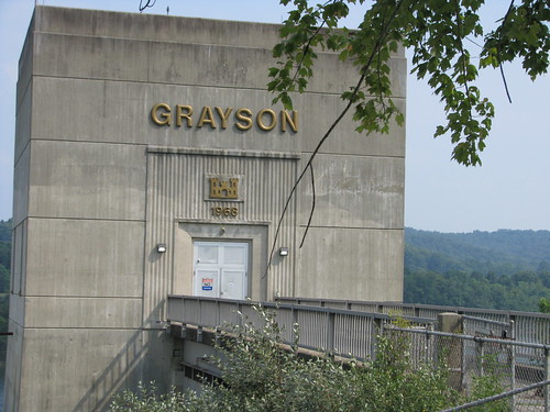
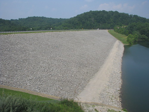
And beginning around 1900, the people of western Carter County around Olive Hill did not appreciate the 30 or 40 mile journey to the county seat of Grayson. Olive Hill was becoming populous given the fire brick industry developing in that portion of the county. And political disputes also suggested a division. On February 9, 1904, the governor signed into law the formation of Beckham County out of portions of Carter, Elliott and Lewis counties with Olive Hill being designated as the new county seat.

Beckham County needed revenues and issued tax bills to her citizens. Mr. Zimmerman, once a resident of Carter County, challenged his $75 bill. Carter County, defending her tax base, joined with Mr. Zimmerman to challenge the constitutionality of Beckham County which was soon out of existence.

Though the name wouldn’t be known for a significant portion of the epoch, Kentucky’s geopolitical and cartographic history spans more than four centuries. Today, the boundaries are governed by Chapter 1 of the Kentucky Revised Statutes – statutes which reference U.S. Supreme Court decisions decided as late as the 1980s. And within these boundaries, Kentucky has been divided into public and private lands.

Surveyors and others have called the points which would make these divisions. Since 1983, the state legislature has authorized the use of GPS coordinates in addition to the metes and bound system which has added accuracy to the whole system.

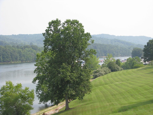
Yes, the “sun shines bright on my old Kentucky home” as measured from the “stone at the seven pines” and beyond.

Happy 100th Birthday to Grace Brammell

Grace Sammons Brammell
100 Years Young

On February 16, 1913, Grace Sammons was born to William Franklin Sammons and Millie (Rucker) Sammons in Johns Run, Carter County, Kentucky. Over the weekend, Grace’s family and friends gathered in Grayson to celebrate her 100th birthday.

For several hours, Grace “held court” as well-wishers came and greeted the centenarian and life-long Carter Countian. During the celebration, Grayson mayor George Steele gave Grace a key to the city. He also read a proclamation of the city council which declared February 16, 2013 as “Grace Brammell Day” in the city of Grayson. Senator Robin Webb moved the Kentucky State Senate to recognize Grace “upon the auspicious occasion of her 100th birthday.”  Governor Steve Beshear commissioned Grace Brammell to the Honorable Order of the Kentucky Colonel. And the President and First Lady sent their greetings from The White House.

Grace was married to Fred Powers Brammell of Hitchins (also Carter Co.) in 1937; the two had eloped at the Morgan County Courthouse in West Liberty. Fred and Grace had five children and were lifelong farmers until Fred passed away in 1996; Grace has remained on the farm she and her husband built in the 1950s. She continues to be an active member at the Pactolus Methodist Church, of which she was a charter member.

Grace Brammell and her great-grandchildren

Grace and Fred had five children, twelve children, countless grandchildren (including my wife) and greatgranchildren (incuding the lil’ Kaintuckeean and the lil’ Miss Kaintuckeean). And though she does show signs of age, Grace remains full of wit, of beauty, of love, and of faith. She is an inspiration to her family and to all those with whom she comes in contact.

Happy Birthday, Mawmaw! More pictures on flickr.

Update (June 21, 2018): At age 105, Grace “Mawmaw” Brammell left this world behind. Rest in peace, Mawmaw.

NoD: Celebrate Veterans Day by Thanking a Doughboy

Carter County, Ky. Jamestown, Ky.
Doughboy – Grayson, Ky. Doughboy – Jamestown, Ky.

I’m sure that around the country, hospitals will see an uptick in deliveries and scheduled caesareans. And many couples will share their nuptials on this memorable date: 11-11-11. Grooms won’t have to worry about forgetting that anniversary!

Rowan County, Ky.
Morehead, Ky.

But November 11 also has a symbolic meaning in our country and around the globe for on “the eleventh hour of the eleventh day of the eleventh month” in the year 1918, hostilities with Germany ended thus concluding “The Great War” (n/k/a World War I). In America, this date was celebrated for years as Armistice Day until after the conclusion of another great war – World War II – that the date became known simply as Veteran’s Day. In other countries, November 11 is referred to as Remembrance Day.

I am particularly fond of the original term Armistice Day because of its historic context. The young Americans in the early part of the twentieth century crossed the ocean to fight the Germans in an era when crossing the ocean wasn’t something you did for reasons other than immigration. Earlier this year, Frank Buckles of Missouri passed away – he was the last of the American doughboys from World War I.

Pikeville, Ky.
Pikeville, Ky.

Statues of  World War I doughboys stand in memorium around America in front of courthouses, in cemeteries and in town squares. In fact, the doughboy statue is the most reproduced life-size statue in America with 140 known copies. First designed and sculpted by E.M. Viquesney in 1920, “The Spirit of the American Doughboy” went through a few design changes over the years. Though most don’t realize it, Viquesney’s doughboy is likely the most witnessed sculpture in the United States other than the Statue of Liberty herself.

In Kentucky, eight Viquesney statues are known to exist in the following towns: Grayson, Harlan, Jamestown, Liberty, Monticello, Morehead, Pikeville and Winchester. The first of these to be installed was the Monticello doughboy in January 1923; the last was in Jamestown 75 years ago today on Armistice Day, 1936.

Whatever its name, it is a day to thank the men and women in uniform who have served our country. And though many people only recognize today as being a day when schools, banks and government offices are closed, it is because our soldiers fought that we can enjoy our freedoms today.

Source: Viquesney Database

NoD: Grayson Lake and the Kitchen-Horton House

Grayson Lake - Grayson, Ky.
Grayson Lake – Carter County, Ky.

Named for the Carter County seat, Grayson Lake was formed by the Army Corps of Engineers in 1964 from their formation of an earth and rock dam on the Little Sandy River. Now, almost 75 miles of shoreline in Carter and Elliott counties surround this beautiful lake of approximately 1,500 acres.

Filled with bluegill, bass, catfish, crappie, and trout, the lake is very popular with local anglers. But history has its tale at Grayson Lake as well. Whenever I visit an Army Corps manmade lake, I’m reminded of the scenes from O Brother, Where Art Thou?
when the valley is flooded saving George Clooney et al. from the gallows  (Youtube) as well as the following scene where he opines on the New South being hooked up to the grid (Youtube). Surely, much in the flooded valley of Grayson Lake was lost when the waters rose in the mid 1960s.

Grayson Lake - Grayson, Ky.One structure, however, was moved from its foundation on the north bank of the Little Sandy River and now rests 700 feet northeasterly in a recreational area adjacent to the lake. The historic Van Kitchen Home (pictured at left) was built around 1835 by Elijah Horton. This log cabin was built in the “saddlebag” design, meaning two cabins close enough to one another that they share a common chimney. Although once prevalent through eastern Kentucky and West Virginia, the design has become quite rare.

After reaching Grayson during his “masterful retreat” from the Cumberland Gap, Gen. George Morgan (USA) continued toward Camp Dennison, Ohio with the Thunderbolt of the Confederacy – John Hunt Morgan – nipping at his heels. Gen. George Morgan supped at the Horton house and his men camped nearby, but their stay was disrupted by Gen. JHM’s men and a skirmish ensued. Bullet holes are still visible in the walls of the ol’ saddlebag’s second floor. The Van Kitchen House, named after the last family owning the house prior to the government’s acquisition in 1965, was listed on the National Register in 1974.


Grayson Lake - Grayson, Ky. Kitchen-Horton House @ Grayson Lake - Grayson, Ky. Grayson Lake - Grayson, Ky. Grayson Lake - Grayson, Ky.
additional photos on flickr

NoD: Honest Bill from Olive Hill

Honest Bill from Olive Hill - Carter County, Ky.
Plaque on Marker at Courthouse Square – Grayson, Ky.

As you know, politics in Kentucky is “the damnedest.” Which may be the only logical explanation behind the slogan used by William Jason Fields in each of his campaigns: “Honest Bill from Olive Hill.”

Born in Willard (Carter Co.), Ky. in 1874, Fields went on to serve Kentucky’s Ninth District in Congress from 1911 to 1923 when he resigned from Congress to assume the governorship in Frankfort. He was governor for one term, 1923-1927. When Fields left the governor’s mansion, he signed 148 pardons and spent much time after his governorship defending “the innocence of convicted-and-pardoned murderers, manslaughterers, robbers forgers, embezzlers, housebreakers, barn burners.” (Time, 12-27-1927).

So how “honest” was Bill? Well, he did have that unusually high number of pardons. And it is unclear what favors he offered when he received the Democratic nomination for and was elected governor in 1923. Interesting story: the party’s nominee died and runner-up, Alben Barkley, declined the nomination (he had decided to run for U.S. Senate, a good decision for the later Vice-President). So the party’s central committee selected Wm. Jason Fields as its nominee. Despite a factious Democratic Party, Fields garnered the support of the all-powerful Jockey Club, U.S. Senator A.O. Stanley, Louisville banker James B. Brown, and our good friend Billy Klair to secure his election. [*]

Although he issued too many pardons, engaged in nepotism and was nominated and elected through a series of back-room deals, he was still “Honest Bill from Olive Hill.” Well, ain’t politics the damnedest? But, hey… he did sign into law the creation of the Kentucky Parks System. Thanks, governor!

No Destination: Olive Hill (& Beckham County)

My initial reaction in seeing the old East Carter High School: imagine climbing all of those steps! Now the Olive Hill Historical Society, there is a mural showing the history of Olive Hill directly below this picture. From the mural, you learn that the Chesapeake & Ohio railway came through town from 1910 to 1971 and that the town was established in 1861.

For 90 days in 1904, Olive Hill was the county seat of Beckham County. Beckham County (originally to be called Hardscabble County, later Goebel County) was named after the Governor who signed it into creation on Feb. 9, 1904. Citizen Zimmerman, upon receiving a tax bill of $75.00, soon challenged the county’s legitimacy. Joined by Carter County (who did not want to lose the tax base), the Kentucky Court of Appeals ultimately dissolved Beckham County (finding it unconstitutional under Kentucky’s 1891 Constitution which geographically restricted the formation of new counties) on April 29, 1904.

No Destination: Pactolus

Pactolus. I’ve been here so many times. My father-in-law’s family was one of the founding families of the church (Pactolus Methodist) pictured above, c. 1922, and the family remains in the area.

Iron furnaces around this part of the state were quite common and it is believed that the Pactolus furnace (no longer in existence, last blast in 1835) was the first in the state. This unincorporated community is considered a part of Grayson.

No Destination: Grayson

At the convergence of the AA Highway and Interstate 64, the formerly sleepy town of Grayson is busy. Main Street (pictured above) is quiet as the new main strip is the Carol Malone Blvd. (named after an opera singer from Grayson). It was founded in the early 1800s by salt makers and was originally known as Crossroads, but the community was renamed Grayson when it became the county seat of Carter in 1838.

The town is also home to my wife’s family and Kentucky Christian University. I will return to Carter County many times with many more posts.