NoD: McCreary County from Mile Marker 0

KY-TN State Line @ US27
US 27 at the Tennessee State Line – McCreary County, Ky.

On a recent trip to Tennessee, I found myself eschewing the interstate in favor of Highway 27. From the Tennessee border, one crosses through McCreary, Pulaski, Lincoln, Garrard and Jessamine counties and the trip marked my first venture into McCreary County.

When not travelling by interstate, a state line can be a fascinating place. A noticeable line in the asphalt marks where one transportation’s work ends and another begins. ‘Unbridled’ signage encourages entrance to Kentucky while the “McCreary County” and “Mile 0” signs are mere statements of fact. But the broader picture is grand. At the state line, Kentucky’s state flower – goldenrod – grows. A cigarette store in Kentucky sits only feet from Tennessee, but offers our neighbors to the south a great discount on tobacco due to our lower taxes on the product. But Rocky Top isn’t short changed as they host a liquor store a mere 15 yards from dry McCreary County.

McCreary County is quite unique in that its county seat, Whitley City, is not an incorporated city. In fact, McCreary County has no incorporated cities or towns — the only county in Kentucky with such a claim. McCreary County was the last Kentucky county – #120 – when it was formed in 1912 from Pulaski, Wayne and Whitley counties.

During the Civil War, the area was very pro-Union. Even so, the county is named after a Confederate war hero and two-term Kentucky governor, James B. McCreary. It is a beautiful county that creates another beautiful entrance into the Commonwealth.

KY-TN State Line @ US27 KY-TN State Line @ US27 KY-TN State Line @ US27 KY-TN State Line @ US27

Pictures by the Kaintuckeean on flickr.

EV: Resting Place of Henry Clay (Lexington Cemetery, Part VII)

Tomb of Henry Clay – Lexington, Ky.

When most people think of the Lexington Cemetery, they probably immediately think of the Henry Clay monument. And for good reason. It dominates the skyline of this area of Lexington. Though, as a curious aside, it’s really tough to see the monument from the cemetery below. It takes up an entire section (Section M) of the cemetery and is surrounded by a dense group of cherry trees.

When Henry Clay died in June of 1852, the ensuing ten days of memorials and mourning were national news. The day after he was buried, a group met at the courthouse in Lexington to begin planning “a national monument of historic proportions.” They certainly achieved their goal.
The monument was completed in 1861, but because of the Civil War, Clay’s body was not laid to rest there until 1864, when both he and his wife’s bodies were placed there. The monument stands on a small hill, and Clay faces east, towards his home – Ashland.
Curiously, the monument has had a rather rough time over the years. In 1909, a storm knocked the head off the statute, necessitating a new statue to be built at the cost of $10,000. Then in 1910, the replacement statue was struck by lighting and lost its right hand and leg. The statue was once again repaired for another $10,000.
By the time the 1970s rolled around, the statue was a mess, as technically, there was no group responsible for its upkeep. The Cemetery had long ago deeded the land to the Henry Clay Monument Association, a group that no longer existed. To remedy this issue, the orphan monument was vested to the city by the Fayette Circuit Court. The monument saw a complete restoration at the hands of the city in 1976. The city transferred ownership to the Lexington Cemetery in 1999.

NoD: The Graves of Seven Who Fell in ‘The Masterful Retreat’

Rural Cemetery - Elliott County
Unmarked Grave – Elliott County, Ky.

Momma always instructed us not to “cut off the hand that feeds you.” This old maxim shouldn’t be forgotten in life or in battle.

The Cumberland Gap was a strategic link through the Appalachians during the Civil War and control of it was a constant struggle. After the battle of Ivy Mountain, Union troops became increasingly bold in southeastern Kentucky. By the middle of 1862, General George W. Morgan saw his opportunity to take the Cumberland Gap. To do so, however, he (and his men and their artillery) had to cross very rugged terrain. The end result was a loss of their supply line.

By June 17, 1862, General Morgan had taken control of the Cumberland Gap, but his men were relying on foraging for their rations. After taking the Gap, General Morgan wrote to Secretary of War Edwin Stanton: “The enemy evacuated this American Gibraltar this morning … and DeCourcy’s brigade took possession.” Gibraltar being, of course, a reference to the straight by which one enters the Mediterranean Sea.
Ultimately, however, the Confederate Army sought an invasion of Kentucky (ultimately leading to the Battle of Perryville) through Tennessee. With no supply line and the threat of being surrounded by rebel forces, General Morgan abandoned the Cumberland Gap on September 17, 1862 and began what would be known as “The Masterful Retreat” toward Grayson, Kentucky.

Along the way, the Union troops under Gen. George Morgan were under constant threat from the tactics of CSA Gen. John Hunt Morgan and his 1,200 cavalry riders. As USA Morgan’s 7th KY Division made its retreat to Grayson, a constant calibration of security tactics was necessary because of CSA Morgan’s guerrilla-like ambushes. The only “roadway” through Elliott County wide enough for the 7th KYwas the riverbed of the Little Sandy River, which flowed through many gorges and narrows perfect for ambush.

It was said the the rebels “fought vigorously with ax and torch, felling trees, barricading the road, destroying bridges, and making every barricade cost a skirmish and time.” At one such skirmish, seven men of the Union’s 7th Kentucky Division fell and are buried in this little cemetery located two miles south of Sandy Hook.

It is likely that this cemetery also served as a family cemetery for local residents as there are more than seven graves present. Today, as is the case with so many Civil War sites, this rural corner of Elliott County is being developed, but a roadside marker (“Skirmish Here“) records the spot in the annals of history.

The remainder of the 7th Division arrived in Grayson after a grueling 16 day march.

More pictures are available here.

Bibliography

NoD: Battle of Ivy Mountain

Battle of Ivy Mountain - Floyd County, Ky.
Ivy Mountain Memorial – Floyd County, Ky.

In the fall of 1861, General William Tecumseh Sherman, then the head of the Department of the Cumberland, heard rumors that a concentration of Confederate troops was amassing at Prestonsburg. In response, Sherman ordered Brig. Gen William O. “Bull” Nelson from his station at Maysville who was joined by Louisa-based Colonel Joshua Sill in driving Confederate forces south through Hazel Green and West Liberty.

Always short on supplies, Big Sandy Valley Confederates were also running short on ammunition in Prestonsburg. Under the direction of Capt. Andrew Jackson May, the men fell back on November 5, 1861, toward Piketon (n/k/a Pikeville). In Pikeville, the majority of the region’s Confederates were stationed under Col. John S. Williamson.

On November 8, 1861, May’s men took a stand to slow the southerly advance of Union forces. A volley temporarily halted Union troops, but reinforcements quickly overwhelmed May’s ragtag Rebels who retreated toward Virginia.

Confederate forces under Captain May left in their wake fallen trees and burned bridges, slowing the Union’s eventual taking of Piketon. Effectively, this was the end of the fight for the Big Sandy Valley as the mountains of eastern Kentucky were a Union stronghold for most of the Civil War.

Casualty counts from Ivy Mountains differ, but most reports indicate that Union forces suffered 30 casualties (6 killed; 24 wounded). Colonel Williams wrote of the Confederates’ loss: “10 killed, 15 wounded, and 40 missing. Some of the missing men have gone back to their homes, and others join us daily.” Most notable among Rebel losses was the state senator from Greenup County, Kentucky, Lt. Henry M. Rust “who fell gallantly in the discharge of his duty.”

“Bull” Nelson died in 1862; Jessamine County’s Camp Nelson was named in his honor, as is the adjacent national cemetery.

The monument to the Ivy Mountain battle sits adjacent to US 23 was dedicated in 2001 on the 140th anniversary of the conflict. In a few months, the sesquicentennial will be celebrated. The monument is a fifteen foot tall obelisk over an engraved base. As you can see from the picture, Ivy Mountain has been cut away to create and widen US 23. Without a thought, you know that the location is nothing like that seen by General “Bull” Nelson, Captain May, Senator Rust, and the others involved in the conflict. But, a rugged, narrow trail sweeps down toward the banks of the Big Sandy River. With the trees, the brush, and the passing waters of the Big Sandy, the past is much easier to imagine.

More photographs of the Ivy Mountain Memorial can be viewed on flickr.

Bibliography
Eastern Kentucky and the Civil War
Kentucky Encyclopedia
National Park Service

EV: Lexington National Cemetery (Lexington Cemetery, pt. V)

As I mentioned in an earlier post, there are three national historic sites within the Lexington Cemetery. The largest of these is the Lexington National Cemetery. It is one of eight national cemeteries in the state.

During the Civil War, 965 Union soldiers were buried in the Lexington Cemetery. Confederates were buried in an adjoining lot. After the war, the Union lot was donated by the cemetery company to the federal government, which also purchased an adjoining 16,111 square feet in 1867. The whole area was designated a national cemetery and federal soldiers from several surrounding Kentucky counties were brought there to be buried. By 1932 the area was filled, and an additional adjacent lot was eventually purchased.

NoD: Versailles Presbyterian Church

Versailles Presbyterian Church - Versailles, Ky.
Interior of the Versailles (Ky.) Presbyterian Church

On Versailles’ Main Street, the red bricks of the Gothic revival-style Presbyterian Church surround beautiful stain glass windows. Its stately belltower lies on the north end of the church’s gabled roof.

Inside, the square sanctuary features a beautiful pipe organ and two-and-one-half aisles (the third being central to the church, but only extending midway from the rear).

Versailles Presbyterian Church - Versailles, Ky.
Versailles (Ky.) Presbyterian Church

The church’s origins are unclear, but the first Presbyterian pastor in the county was Reverend Adam Rankin who was called to the Glenn’s Creek Church, part of the Transylvania Presbytery, in 1786. In 1788, Woodford County was created from Virginia’s Fayette County. Fortunately, for this early church, Glenn’s Creek was not situated within Versailles as Virginia statute forbade a church from being situated within the limits of a county seat. These rules soon became moot, however, as Kentucky achieved statehood in 1792.

By 1794, not only was a Presbyterian Church operating in the county seat of Versailles — but it was holding services in the courthouse itself! Rev. John Poage Campbell, considered to be the first minister of Versailles Presbyterian Church, preached throughout the circuit and had certainly served in Versailles by the year 1811 when he also acted as chaplain of the state legislature.

The church, erected in 1854, preceded the existing structure on which ground was broken in 1877 with dedication Sunday following on July 28, 1878 by Reverend Gelon H. Rout. Once dedicated, the sanctuary was the largest room in the county and was utilized for a number of civic and community events.

The organ was from the Henry Pilcher & Sons Company of Louisville. Actually, the company originated in St. Louis in 1852, but located to Chicago during the Civil War. Surviving both the war and the Great Chicago Fire of 1871, the company returned south to Louisville in 1874. The organ, built in Louisville, was taken by train to Midway and from there to Versailles on horse cart. The walnut organ crates were even used in the construction of the church’s façade!

More pictures are available by clicking here.

Bibliography
Henry Pilcher’s Sons Organ Company
Historical Sketches of Kentucky,” p. 135.
John Poage Campbell
Versailles Presbyterian Church, “Our History

NoD: West Liberty’s Millstone Monument

West Liberty - Ky.
Millstone Monument – West Liberty, Ky.

On the Morgan County courthouse lawn in West Liberty rests a most peculiar, yet appropriate, monument. So many communities in Kentucky, across America and around the world began where a stream provided the power to turn the mechanisms of a gristmill – turning crops into flour.

The owner of the mill, a millwright, would convert a farmer’s crop to flour and would keep for himself some of the end product – a miller’s toll. Around these mills, other forms of commerce would develop creating many of the towns we know today. Of course, most of the mills are long gone. But Morgan County has preserved this token of history with a courthouse lawn monument to the millstone.

In 1816, Edmund Wells established his grist mill on the Licking River. This grist mill quickly grew in importance for the area’s farmers, and the “Wells Mill” community quickly grew as all roads in the area found Wells Mill as their focal point. To account for his travelers, Wells also owned and operated a tavern in Wells Mill. In 1822, the General Assembly created Morgan County from Floyd and Bath counties; on March 10, 1823 the justices of the newly formed Morgan County, including Wells, met at Wells’ tavern to make effective the establishment of Morgan County. The time and place of this meeting was set forth in the Act establishing the county.


West Liberty was established as the county seat upon 39 acres donated by Edmund Wells. He donated an additional two acres for the public square whereupon he was contracted to build the county’s first jail and courthouse.

The millstones used in this monument were not, however, from Wells’ mill. Instead, they were from the mill of Capt. John T. Williams who served in the Confederate army during the Civil War. After the war, Williams established his own mill on the Big Caney Creek in Morgan County. In 1869, however, Elliott County was formed and the Big Caney Creek is wholly within the bounds of Elliott County.

Capt. Williams’ links to Morgan County and to Edmund Wells, however, are strong. Williams’ father was squire John T. Williams who, like Edmund Wells, was appointed by Governor Adair in 1822 as one of the first justices of Morgan County. Capt. Williams’ father was present at Wells’ tavern on March 10, 1823, and it is his son’s millstones that forever memorialize the import of the mill in Morgan County’s history.

Bibliography
“Acts of the Kentucky General Assembly”, 1823, pages 145-147 [*]
Ancestors of Squire John T. Williams
Kentucky Encyclopedia, “Morgan County
Plaque at the Millstone Monument

NoD: Judge John E. Cooper House

Judge John Cooper House - West Liberty, Ky.
Judge John E. Cooper House – West Liberty, Ky.

On Main Street, at the northern edge of Morgan County’s seat, stands the Judge John E. Cooper House – the oldest extant house in West Liberty. Built in 1872/73, this two-story frame structure assumes no formal architectural design, but is representative of much of eastern Kentucky’s mid-19th century architecture with one notable exception. The entire house was completed in one construction effort – this rapid build and the scale of the project would have made it a most-impressive structure for Morgan County in the 1870s. The National Register profile for the house makes careful note of this feat, pointing out that it would have been considered symbolic of Cooper’s power and prestige, without being showy.

Judge Cooper was a powerful figure in regional politics and law. In the Civil War, he and his fellow Morgan countians sympathized with the Confederacy and took up arms for her; he was wounded at the Battle of Ivy Monutain (Floyd County) in November 1861. He attended law school and graduated from the A&M College at Kentucky University before returning to Morgan County. There, he married and practiced law before becoming county attorney and, later, state senator. Col. John Thomas Hazelrigg spoke well of the senator during his centennial address in 1876, saying that Cooper was “full of hope and promise, now engaged in the practice of his profession as a lawyer, and is distinguished for his zeal and energy with which he represents the interests of his clients. Although young in years, he has taken a front rank in his profession and bids fair to enroll his name among the first jurists of the Commonwealth.”

Cooper did not disappoint Hazelrigg. In 1883, Cooper was nominated to fill a vacancy on the circuit court. He was repeatedly elected to the position and held the office for 22 years, “longer than any other man.” Of Judge Cooper, Judge Edward C. O’Rear (Ky. Ct. Appeals) wrote: “He was a vigorous executive and worked as hard on the bench for the whole term of his service as at any time whilst at the bar. He not only adjudged the law in his courts, he administered it. A rugged type, powerful physique, dignified bearing, he gave to each case before him the most painstaking investigation.” Judge O’Rear went on to note that Cooper never wore spectacles, “though he read every paper in every case submitted to him, and every authority cited, and prepared with his own pen the instructions to juries, his orders and judgments.”

It is believed that Cooper designed the house which he continued to own until 1896, though construction was completed by Thomas Jefferson Cassity and his son, Reuben. Cooper, however, was known to have done some architectural planning; the plan and specifications for the third Morgan County courthouse were drafted in 1870 by Morgan. Local legend, though improbable, suggests that Morgan modeled the courthouse after the colonial capitol at Williamsburg, Virginia.

Additional pictures of the Cooper House are available on flickr.

Bibliography
NRHP, “Judge John E. Cooper House
NRHP, “Morgan County Courthouse” 

walkLEX: Old Morrison

Old Morrison - Lexington, Ky.
Old Morrison (Transylvania University) – Lexington, Ky.
This logo of Transylvania University is the property of Transylvania University

R. Owens Williams is the President of Transylvania University, but Old Morrison is its face. Mention Transylvania University to those familiar with this great institution, and it will conjure up an image of this impressive  building with its six massive Doric columns rising above the northern end of Gratz Park. Or at least it should… it is, after all, Transy’s logo.

Designed by Gideon Shryock and constructed from 1831-1834, it is the oldest building on campus that is in its original location (the caveat being necessary because of the Patterson Cabin which came to Transy in 1939). Shryock, of Lexington, had recently completed his work on the state capitol in Frankfort when Henry Clay, a member of the school’s board of trustees, sought his services to construct a main building for the college.

This brick building, covered in concrete, is three stories in height and serves as the University’s administrative building. Over time, it has also housed a chapel, classrooms and, during the Civil War, acted as a hospital for both Union and Confederate troops. There are even two bodies lying forever in the crypt at Morrison – Constantine Rafinesque and Saveur Francois Bonfils.

Old Morrison - Lexington, Ky.   Old Morrison - Lexington, Ky.

A fire in 1969 gutted Old Morrison, which was renovated, restored and rededicated on May 9, 1971. It was added to the National Register in 1966. Though his words are over 100 years old, they still are true. Burris Jenkins, president of then-Transy from 1901 to 1906 said that “Morrison is the purest, simplest piece of architecture in the state of Kentucky and the citizens of Lexington would part with any other building in the Bluegrass rather than part with the majestic Doric Morrison College.”

Bibliography
Gratz Park Neighborhood Association
NRHP, “Old Morrison
Transylvania University, “Transy Campus

This post was republished by KYForward.com on August 11, 2011.

walkLEX: Maxwell Place

Each month, the Bluegrass Trust for Historic Preservation offers a deTour to visit a local historic site that has been well-preserved and restored. Please join us on our next deTour. Details on Facebook

Maxwell Place - Lexington, Ky.
Maxwell Place – Lexington, Ky.

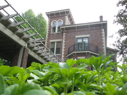
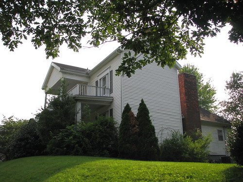
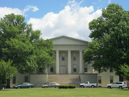
On a very warm afternoon in early June, we gathered on the circular driveway of a brick Italianate villa nestled in the center of the UK campus – right between the Guignol Theatre and the Chem-Phys Building. While architecturally unique and impressive in its own right, Maxwell Place particularly stands out between its mid-20th century neighbors.

Our guide was none other than First Lady Patsy Todd – a wonderful woman who, with her husband President Lee Todd, have led the University of Kentucky since 2001. One of the couple’s first tasks upon arriving at Maxwell Place in 2001 was to have the hedges that surrounded the property removed, allowing visitors, including students, to wander through the grounds. It was a big change welcomed by the students!

Maxwell Place is a storied place in Lexington’s history. Its name comes from Maxwell Springs – a natural spring that was one of three that crossed near the property before feeding the Town Branch of the Elkhorn Creek. The present Guignol Theatre rests above Maxwell Springs and some memory of the old water features exists in the low-lying areas just south of the University’s Student Center.  Henry Clay once said, “No man can call himself a gentleman of Kentucky until he has watered his horse at Maxwell Springs.”

Maxwell Springs received its name from the area’s landowner, John Maxwell. Maxwell was one of Lexington’s earliest pioneers and, it is said, he named the original encampment at McConnell Springs “Lexington” after the recent Revolutionary War victory. With a 1,000 acre tract acquired from fellow pioneer Robert Patterson, Maxwell owned much of what became southeeast Lexington.

During the Civil War, the present-day University campus was occupied by Federal troops and its trees were felled for heating fuel. The owner of the land, the Maxwell Springs Company, couldn’t keep up its payments during the War and in 1870 the entire parcel was sold in a judicial sale.

The “most active and influential” of city councilmen, Dennis Mulligan, led the City of Lexington to acquire the majority of the land at the sale for use as a City Park, while he individually purchased a narrow strip of land on Rose Street. Mulligan, it should be noted, was an Irish Catholic political boss and many believe it was his political machine which boss Billy Klair would later steer and perfect.

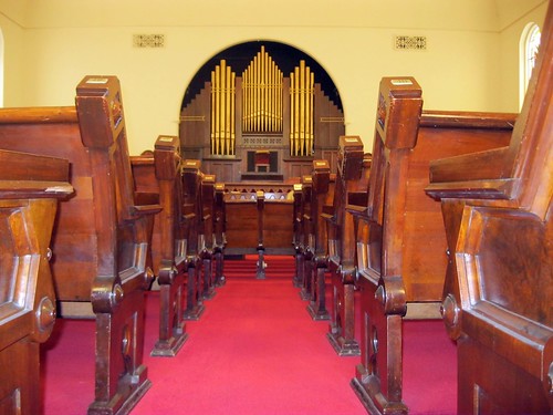
On this narrow strip, Mulligan built for his son a wedding gift: Maxwell Place. The son, James Hilary Mulligan, would serve in a number of political offices in Kentucky, in Washington and abroad. As Speaker of the Kentucky House, Mulligan would retain the services of a young Billy Klair as his page. Mulligan is best remembered, however, for a poetic speech he delivered at the old Phoenix Hotel in Lexington in 1902 entitled, In Kentucky . A copy of the poem hangs in the library at Maxwell Place.

Lexington, vying for the state university and facing strong competition from a Bowling Green bid, offered its old Maxwell Springs land and the rest is University of Kentucky history. The Mulligan family sold its 13 acres, including Maxwell Place, to the University in 1917 for $40,000.

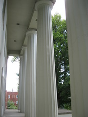
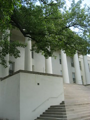
The original architect of Maxwell Place is unknown, though it is believed to have been either Thomas Boyd of Pittsburgh, Pa. or Phelix L. Lundin of Lexington. The two-and-a-half Italianate has been added to and remodeled throughout the years, but many of its original features remain intact. One of its most iconic additions is the arts-and-crafts pergola that stretches from the residence to the circular drive.

Maxwell Place has been the home to many University of Kentucky presidents during its service to the University. It has also been the host destination for many visitors and dignitaries, including First Lady Eleanor Roosevelt who stayed at house in 1934. Despite its storied past, Maxwell Place faced its critics: in the late 1960s, Maxwell Place was slated for demolition as part of the University’s development plan. Fortunately, an effort to preserve the historic structure succeeded so that we can enjoy this property today. Soon Eli Capilouto, the 12th University of Kentucky President, will call Maxwell Place home.

You can check out more pictures of Maxwell Place on my flickr account.

Bibliography
Bossism and Reform in a Southern City: Lexington, Kentucky, 1880-1940
Kentucky Encyclopedia, “John Maxwell” and “Maxwell Springs
Lexington Herald, p. 1. Oct.18, 1967. (local.lexpublib.org)
National Register of Historic Places, “Maxwell Place”