Lee County, Kentucky, and her courthouses

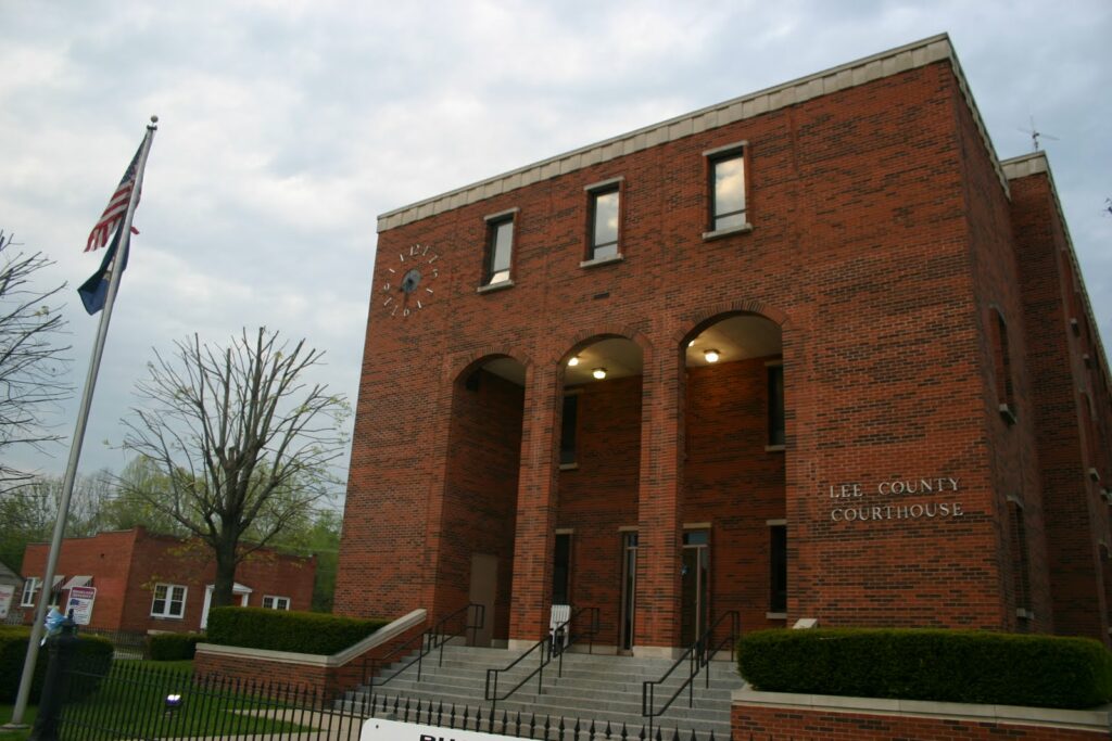
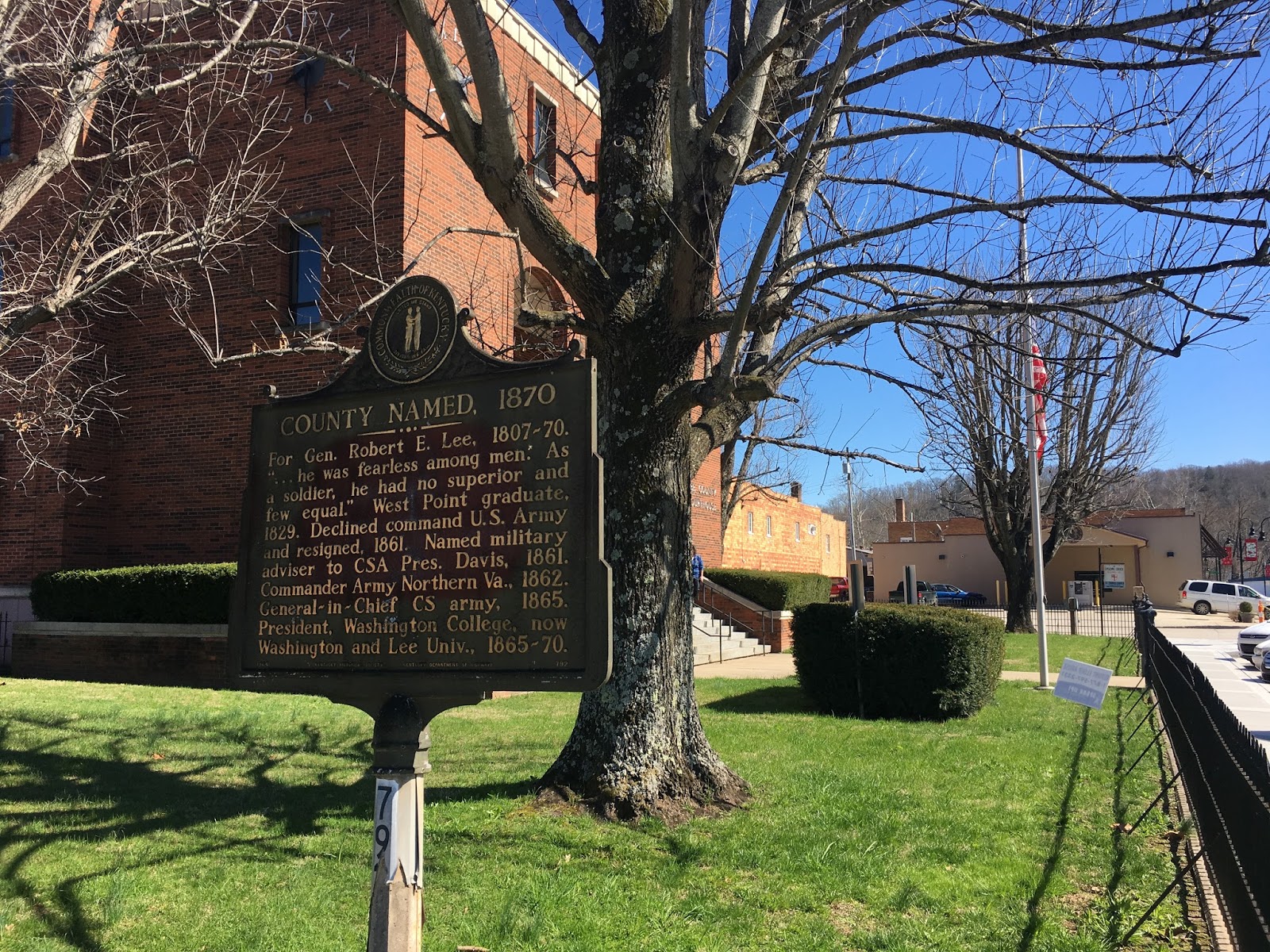
Lee County Courthouse and Historic Marker in Beattyville, Kentucky. Author’s collection

The last time I ventured to Beattyville was in the waning days of the last millennium. With friends, I watched the wooly worms race at the annual festival that draws thousands to the sleepy seat of Lee County. But last week, I returned to do a little business in the Lee County Courthouse.

County Named?

Lee County borders six counties: Powell, Wolfe, Breathitt, Owsley, Jackson, and Estill. It is Kentucky’s 10th smallest county by population (7,594) and the 24th smallest county by square mileage (210 sq. mi.).

Its history is complex. Formed just five years after the end of the Civil War, the area that comprises Lee County (like much of the Commonwealth) was divided during the war. According to the Kentucky Encyclopedia, “Union sympathizers formed a Home Guard, headquartered at Rocky Gap, eight miles north of Beattyville. On November 7, 1864, a Confederate force under the command of Lt. Jerry South fought the 20th Kentucky Militia at the Middle Fork of the Kentucky River in Lee County.”

By 1870, sentiments likely remained divided. The story told on the historic marker outside the courthouse – that the county was named after Confederate General Robert E. Lee – is quite possibly incorrect. That historic marker was erected in 1964, a time when Kentucky’s history was still being rewritten with an unnecessarily southern bent. The Kentucky Encyclopedia raises similar doubts to the necessity of telling Lee’s military accolades on Main Street Beattyville. That article cited “strong Union sentiment in the area” during the War the entry finds “a more likely explanation” in Lee County being named after the county of the same name in Virginia because many of the local inhabitants traced their roots to that locale. Lee County, Virginia, the westernmost county in Virginia, was named after “Light Horse” Henry Lee III (who, coincidentally, was the father of General Robert E. Lee).

The Old Courthouse

The present Lee County courthouse is the county’s second courthouse. The first was built in 1872, two years after the county was formed. That first courthouse was used until 1977, when it was demolished for the present structure.

Lee County Courthouse from 1872-1977. UK Libraries.

Lee County Courthouse from 1872-1977. Library of Congress.
The old courthouse, pictured above, was built by Pryse, Brandenburg, and MaGuire. In 1916, the old courthouse was remodeled and expanded. In 1963, a rear annex was added. Located on Beattyville’s Main Street, the structure faces toward the Kentucky River which is about two blocks away without a significant change in elevation leaving Beattyville’s Main Street (and the courthouse) subject to flooding. In 1957, a major flood put much of Main Street under several feet of water. 

The Current Courthouse

The current courthouse, built 1977-78, was designed by Wichman and Sallee. Just inside the front doors of the modern structure, one immediately recognizes the plaques and cornerstones of yesteryear. A historic note explains:

Four plaques on this wall, the brick used to construct interior walls on the 1st, 2nd, and 3rd floors of this building, and the iron bell mounted in the east outdoor sitting area, were removed from the courthouse which occupied this site from the year 1873 to the year 1977. 

Interior wall inside the Lee County Courthouse. Author’s collection

Lee County’s Historic Places

Because Lee County is a bit out of the way, I tried to see all that it has to offer. From a historical perspective, there are three historic markers and nine sites on the National Register of Historic Places. (six of which are petroglyphs or other prehistoric sites with restricted addresses).

The historic markers are the one first photographed above (“County Named, 1870”), another (“A Masterful Retreat”) was one of many along the path of USA Gen. George W. Morgan’s retreat from the Cumberland Gap to the Ohio River in 1872, and “Kentucky River Forms Here” near where the already united North Fork and Middle Fork join with the South Fork to form the Kentucky River at Beattyville.

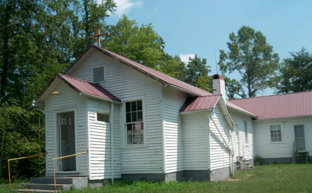
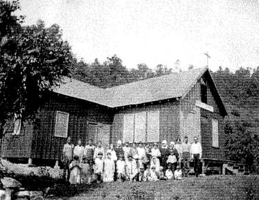
The three accessible sites on the National Register were the Graded School, the St. Thomas Episcopal Church, as well as St. Therese which is the oldest Catholic Church in Eastern Kentucky

Cold Weather and the Woolly Worm (Festival)

Cold, snow-covered Greenup County, Kentucky (Photo: the Author)

Heavier coats are coming out as temperatures drop. The annual rite of passage is upon us as the only thing falling faster than the leaves is the mercury on the thermometer.

I wasn’t particularly pleased when I saw the forecast for the week when I looked on Sunday.

Thirty degrees?

But then again, I shouldn’t be surprised. Should I? I’ve witnessed the warning signs. Falling leaves. Yellow school buses. Football games and basketball practices.

I should have seen it coming, yet every year I am caught off guard by the onset of winter. I’m guessing I’m not the only one?

So what kind of winter is in store for us?

My father, a native of western Ohio, swears by the venerable Farmer’s Almanac which is a fairly decent indicator for long-range forecasting. On the map published in the Old Farmer’s Almanac, Kentucky is treated as the southernmost midwestern state where the forecast is “biting cold & snowy.” Of course, the Rocky Top of Tennessee and the majority of the southeast is simply “chilly & wet.”

Kentucky has been described both as midwestern and as southern, making finding our commonwealth on a map of U.S. regions challenging. And while the cartographer may struggle, it is equally troublesome to reconcile Kentucky’s status as a midwestern state such as Wisconsin and Michigan as it is to find sufficient similarity with Florida.

For generations, Kentucky has been a border state in every sense of the word. During the Civil War, she was represented by a star on the banners of both the Union and the Confederate States. And it remains difficult to categorize her today.

Like so many in Appalachia, we’ve developed our own methods. In communities along the mountain chain, including a significant number in Kentucky, people have looked to something more native in determining the forecast for the upcoming season — the woolly worm.

At about two inches in length, the woolly worm is easily recognizable by the soft black and cinnamon bristles covering its body. The body is divided into 13 segments with each thought to represent a week of winter; each brown segment is thought to reveal a mild week of winter while black segments are indicative of harsher weather.
So what does the woolly worm say is in store? Well, we’ll just have to wait to find out.

That’s because Kentucky’s woolly worms won’t issue their forecast until the 26th Annual Woolly Worm Festival which will be this weekend in Beattyville.

Beattyville is the seat of Lee County and is nestled between the North Fork and South Fork rivers. This confluence creates the headwaters of the Kentucky River.

The small town counts fewer than 2,000 residents, yet its ranks swell each autumn when the woolly worms race, the parade is held, and live entertainment fills the air.

The woolly worm festival in Beattyville is a lot of fun and, if you haven’t been before, it is worth going. Plus, there’s the added benefit of knowing the forecast for the next 13 weeks.

This column originally appeared in the Jessamine Journal
It should not be republished without permission.


With permission of The Jessamine Journal, this post also appeared on The Revivalist.

Oldest Catholic Church in Eastern Kentucky

St. Therese Church – Heidelburg, Ky.

When considering the role of the Catholic Church in Kentucky outside the “golden triangle,” one immediately thinks of the central Kentucky region around Bardstown and Lebanon where many Catholics settled in the nineteenth century building a strong church and faith.

Original Church on Contrary Creek, ca. 1925

One, however, does not immediately think of the hills of eastern Kentucky. Although Catholic families can trace themselves to eastern Kentucky communities long before, it was not until 1927 that a Catholic church was established in eastern Kentucky. In Lee County’s Heidelburg community, four families established St. Therese at Contrary Creek “down in the holler.” Families worshipping there had as much as a two hour trek by foot to reach the small church by Contrary Creek.

In the 1940s, the decision was made to relocate the church onto the mountain above the holler. In 1948, the present wood frame clapped board church was constructed with its materials being reused from the old church on Contrary Creek. Its white siding and red roof are in stark contrast to the lush, green forest that surrounds it.

Regular services ceased in the 1990s and since 2001 the Catholic diocese of Lexington has designated St. Therese as an oratory, or house of prayer.

After recommendation by the Kentucky Heritage Council’s Preservation Review Board, the National Register of Historic Places included St. Therese Church into the register on February 28, 2012. With hope, this designation will enourage and promote preservation at this house of worship.

Sources: NRHP Application; Queen of All Sts. Parish
Photos: Ky. Heritage Council in the National Register Application

Lee County Courthouse – Beattyville, Ky.


As I have mentioned before, my wife’s family is from Whitesburg, so I frequently find myself in Eastern Kentucky. I noticed the last time that I put up an update on my status that I had inexplicably failed to make it Lee County, which seemed like a huge hole in my map. So last evening, I was headed to Jackson to meet the in-laws halfway, and I decided that on the way back we would swing through Beattyville instead of Campton.
The drive from Jackson to Beattyville is spectacular. State highway 52 runs parallel to the railroad tracks, and the tracks run a considerable height above the roadway. This means that occasionally, a few really amazing old tunnels run underneath the tracks. I’ve never really driven side roads through the mountains, and after this trip, I can highly recommend it. The roads might be a little crazy at times, but you get a completely different experience than the one you get sticking to the Mountain Parkway.
Beattyville reminds me a lot of Morehead. The Main Street areas are just very similar. I’ve recently become a big fan of the Kentucky Explorer, a really interesting little magazine full of history and photos. According to a recent issue, Beattyville had a population of 400 in 1879, with a 4 lawyers, a couple of general stores, several hotels, a flour mill and a grist mill.
When I came up to the courthouse square, I immediately noticed a couple of buildings across the street that looked like they had been pretty heavily damaged by fire. I had forgotten about the Beattyville fire of 2009, which destroyed an entire block of the city that sits across from the courthouse pictured above.
So I was taking my pictures and walking around the courthouse square when I noticed a sign that stated that Beattyville is a part of Homeland Security initiatives, and any suspicious activity would be reported to local authorities. I started to ask myself what sort of suspicious activities might be happening in Beattyville, when the realization struck me that a stranger taking pictures of the courthouse was probably pretty unusual. So I got in the car pretty quickly.