
 |
| The Zero Mile Marker – Lexington, Ky. |
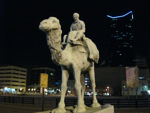
Where the once mighty Phoenix Hotel stood, the Phoenix Park “rose from the ashes” of the old hotel and failed World Coal Center development. In the northwest corner of the park, at the corner of East Main Street and South Limestone, a barefooted traveler looks eastward from his perch atop his camel. With his heavy bags, this Bedouin traveler makes no progress despite giving great perspective to others.
When driving on interstates and highways, do you wonder how the transportation authorities determine how many miles it is to Lexington? With Lexington’s city limits extending to the county line, the distance would vary depending on the direction of your approach. A constant is needed and this camel is that constant. It also is the point that determines whether a Lexington road is east or west, north or south. It is the center of Lexington. Sort of.
This supposed constant has been located in three different locations around downtown Lexington. Originally, a granite marker was dedicated by the Lexington Automobile Association on November 20, 1926, in front of the grand Union Station on Main Street (at Walnut, now MLK Blvd, St.). The Bedouin and his camel atop the granite stone was a gift from William Ingram, the then-owner of the Lexington Granite Company, who was the artist who created the bronze statue.
In 1961, the Union Station was demolished and the zero mile marker was removed to the courthouse lawn. The marker was again moved in 1990 to its present location, though its base (and the language on it) was replaced. Removing the language which mirrored the Washington, DC zero-mile marker, “Starting Point from Lexington On All Highways” to include a reference only to the “Zero Milestone,” the marker also boasts its new location: “Phoenix Park.”
This post appeared on KyForward on July 11, 2011.
Bibliography
Art Inventories Catalog
Lexington Herald-Leader (local.lexpublib.org)